Range image-based 3D spatial data processing method and device

A depth image and three-dimensional space technology, applied in image data processing, electrical digital data processing, special data processing applications, etc., can solve problems such as rapid loading of original data, large calculation time, and small data volume, etc.

Inactive Publication Date: 2009-09-16
BEIJING UNIVERSITY OF CIVIL ENGINEERING AND ARCHITECTURE
View PDF0 Cites 104 Cited by
  • Summary
  • Abstract
  • Description
  • Claims
  • Application Information

AI Technical Summary

Problems solved by technology

The second is obtained from aerial remote sensing images by photogrammetry, but it is much smaller than the amount of point cloud data obtained by laser measurement technology
When drawing a grid with a large amount of data, these methods play a certain role in optimization. For example, Out-of-Core technology is a commonly used technology in computer graphics display to speed up the display speed. The data to be displayed is organized according to certain rules. In the external memory, the data in the external memory is directly transferred

Method used


Image

  • Range image-based 3D spatial data processing method and device
  • Range image-based 3D spatial data processing method and device
  • Range image-based 3D spatial data processing method and device

Examples


Embodiment Construction

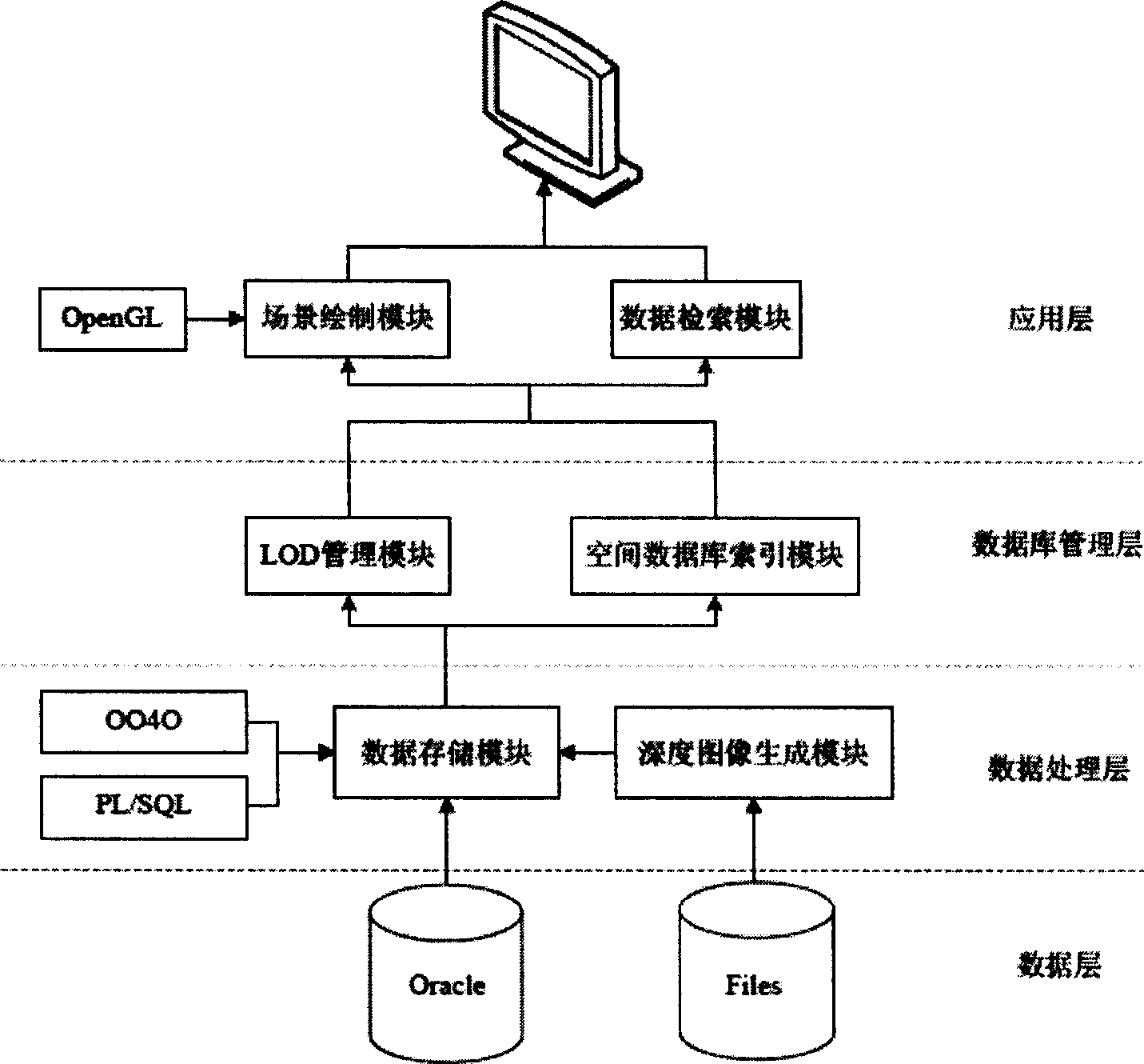
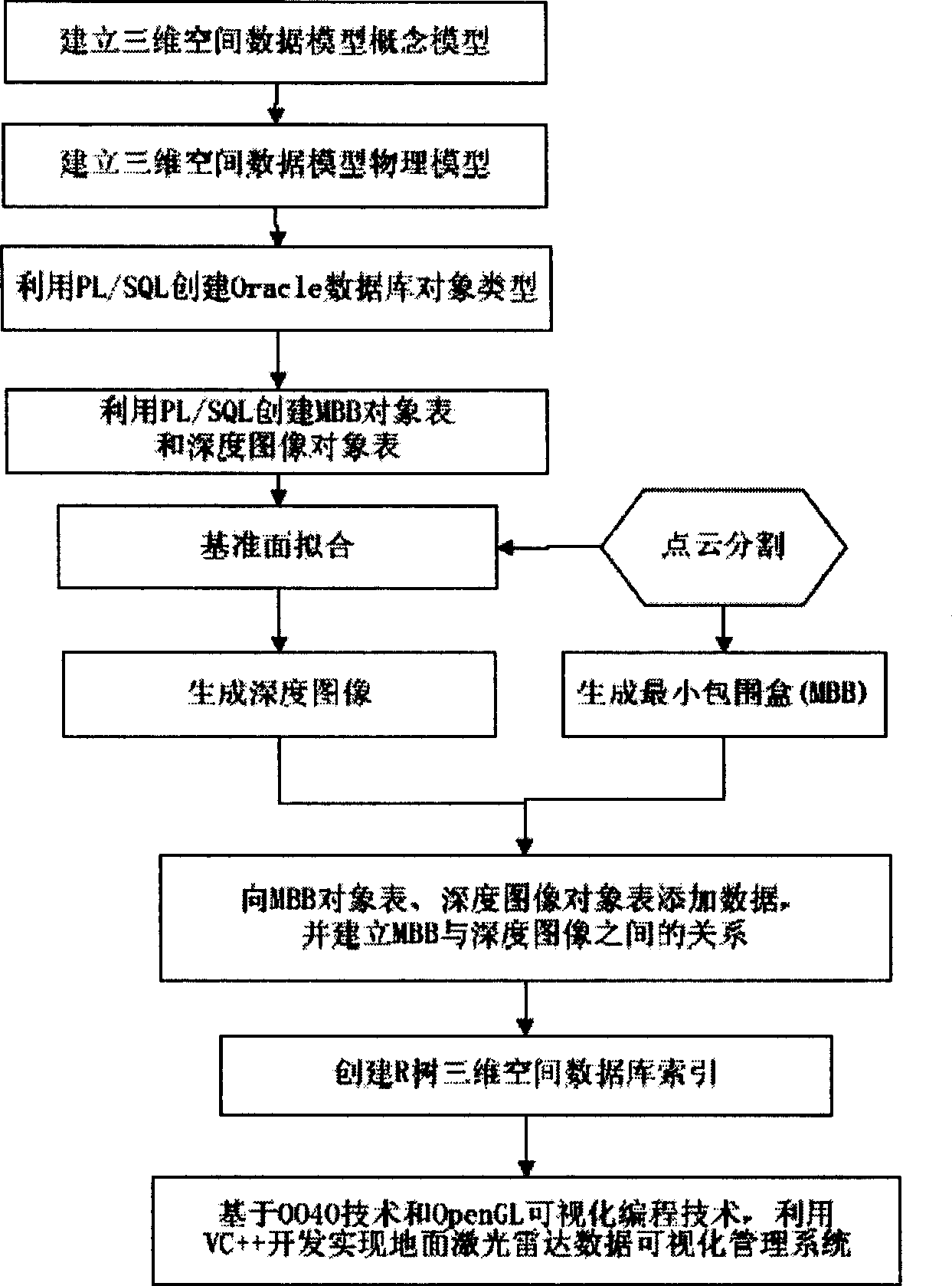
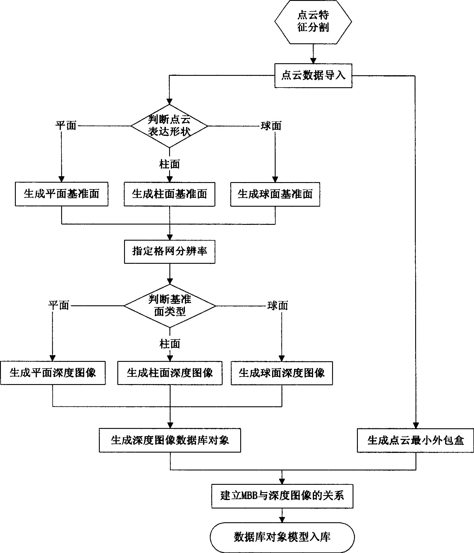
[0058] Specific embodiments of the present invention are described below in conjunction with the accompanying drawings: In this embodiment, the ground laser radar scanning data of a certain ancient building is subjected to feature segmentation according to beams, columns and partial tile components, and corresponding depth images are generated and stored in Database, and then use the corresponding visualization technology to realize the rapid visualization of massive depth images.

[0059] Table 1 Environment configuration table

[0060] software configuration version quantity Configuration Environment Microsoft Windows XP Professional Service Pack 2,

Intel(R) Xeon(TM) CPU 3.00GHZ, 2.00GB memory 3 units database

Oracle 10g, PL / SQL language, Oracle Objects for OLE

(OO4O) Development Kit 1 serving

device, 2 guest

client Database Model Design Tool PowerDesigner 11 graphics library OpenGL graphics library softwar...


PUM


Abstract

The invention relates to a range image-based 3D spatial data processing method and a device. In the method, ground laser radar is adopted to scan an object to obtain 3D point cloud data on the surface of the object; a database object table is established by a PL/SQL programming approach; a reference datum is fit according to point cloud which is segmented in advance to generate a minimum bounding box (MBB) of the point cloud and subsequently generate the range image according to the reference datum obtained by fitting. Later, data of the MBB and the range image are written into the database object table and the relation between the MBB and a range image object is established, subsequently, R tree 3D spatial database index is established for the database objects which enter the database, finally, visualization is realized based on Oracle Objects for OLE (OO4O) and OpenGL.

Description

technical field [0001] The invention belongs to the fields of computer graphics and three-dimensional visualization, and relates to a method and device for processing three-dimensional space data based on depth images. Background technique [0002] In the 1990s, a new measurement technology that used terrestrial lidar to obtain three-dimensional information of space objects appeared. The data obtained by terrestrial lidar scanning can express objects in detail, and for objects with complex structures, such as those that are more complex than modern buildings There are many ancient architectural structures, the amount of data obtained by scanning is not only huge, but also the data has the characteristics of typical ancient architectural components. Therefore, how to effectively segment, simplify, model rebuild, and model organize and manage large-scale 3D laser scanning data of ancient buildings according to different characteristics, so as to achieve fast browsing and smoot...

Claims


Application Information

Patent Timeline
IPC IPC(8): G06T17/00G06T15/00G06T11/00G06F17/30
Inventor 王晏民危双丰
Owner BEIJING UNIVERSITY OF CIVIL ENGINEERING AND ARCHITECTURE
Why Eureka
Try Eureka