Real-time navigation system of 3G on-board computer

A vehicle-mounted computer and navigation system technology, applied in the field of 3G vehicle-mounted computer real-time navigation system, can solve the problems of difficulty in promotion and popularization, single-way real-time road condition information release, and high construction and renovation costs.

Active Publication Date: 2009-12-02
STATE GRID CORP OF CHINA +1
View PDF0 Cites 101 Cited by
  • Summary
  • Abstract
  • Description
  • Claims
  • Application Information

AI Technical Summary

Problems solved by technology

Its navigation map is outdated, cannot reflect real-time road conditions, complex operation, poor entertainment function, poor expandability, too small screen, unreasonable navigation route setting, needs to be fixed by a bracket to obstruct the line of sight, needs a connecting cable to charge, cannot realize visual reversing, cannot There are many reasons such as connecting to the car audio, unable to communicate in real time, unable to display real-time road conditions, unable to query real-time vehicle information, unable to connect to the driving computer, unable to access the Internet, unable to realize mobile office, too small storage space, and poor processing and computing capabilities, etc. Navigation systems and terminals cannot meet the needs of people today
Even the more advanced TMC real-time navigation systems currently under construction in Beijing and Shanghai cannot meet all the requirements of modern people for vehicle-mounted real-time navigation systems.
TMC simply uses the broadcast signal to send real-time road condition information to the vehicle-mounted terminal for decoding and displaying on the navigation map. It can only realize one-way real-time traffic information release (refresh once every five minutes at the highest speed) and cannot realize real-time interactive navigation. Real-time traffic navigation, real-time vehicle information query, real-time communication (voice and video), real-time vehicle monitoring, real-time vehicle scheduling, three-dimensional dynamic road classification, multi-source interactive traffic information collection, intelligent active real-time navigation, real-time navigation path planning, dual Practical functions such as channel real-time dynamic positioning, dynamic point-to-point real-time positioning, intelligent transportation and vehicle management, etc., and equipment construction and transformation costs are high, operations are complicated, entertainment functions are poor, scalability is poor, Internet access cannot be realized, mobile office cannot be realized, and broadcast signals are required Disadvantages such as coverage and the need for a unified system by terminal manufacturers make its promotion and popularization very difficult

Method used


Image

  • Real-time navigation system of 3G on-board computer
  • Real-time navigation system of 3G on-board computer
  • Real-time navigation system of 3G on-board computer

Examples


Embodiment Construction

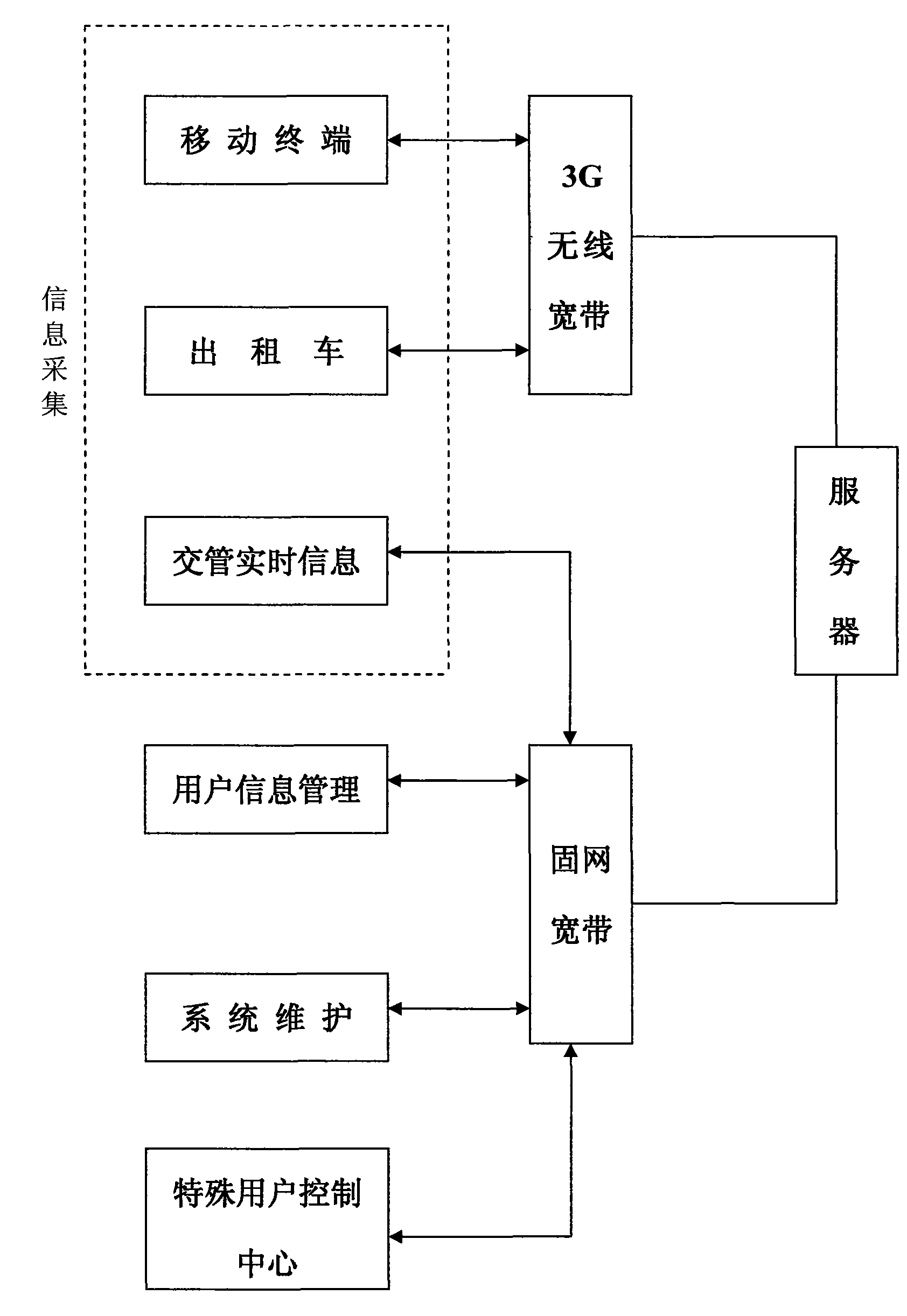
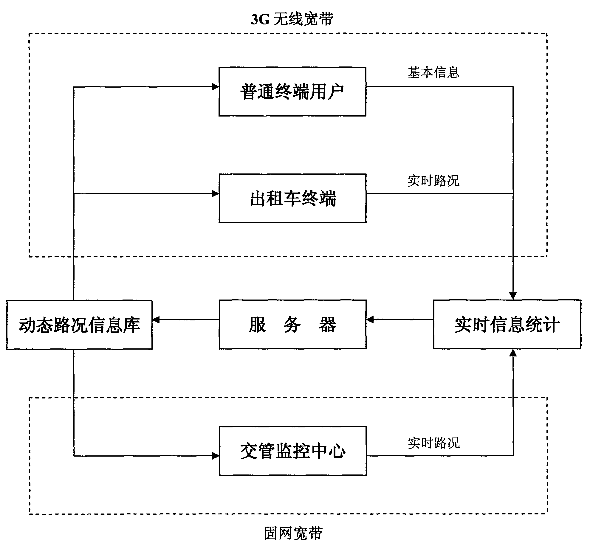
[0018] This system is divided into three parts: information collection, server and terminal, which are respectively connected by fixed broadband, 3G (or 4G and other wireless broadband) wireless broadband, and perform data exchange to realize the real-time navigation system.

[0019] 1. The information collection system includes the following parts:

[0020] 1) Video data collection device for traffic monitoring center. Use fixed broadband to connect the intersections, traffic video data and servers of traffic monitoring centers in various cities, and send them to the servers on the public network in real time through broadband for processing and then provide them to mobile terminals for download. It can provide information and time such as road traffic conditions, intersection traffic conditions, accident congestion, road maintenance, traffic control restrictions, traffic light interval time, and real-time information announcements issued by traffic control departments. And ...


PUM


Abstract

The invention relates to a real-time navigation system of a 3G on-board computer, which uses the on-board computer (on-board or handheld computer, PDA, PPC and other equipment in any form) as a navigation display and an operation terminal and realizes real-time road condition navigation, intelligent traffic and vehicle management, sound and video information exchange, vehicle information inquiry, dynamic point-to-point real-time positioning, road traffic and automatic charging for parking and other functions through data exchange between 3G(or 4G, WIMAX and other wireless broadband) wireless Internet and a real-time traffic information server of public network.

Description

technical field [0001] The present invention uses a vehicle-mounted computer (any type of vehicle-mounted and handheld computer, PDA, PPC and other equipment) as a navigation display and operation terminal, and communicates with a public network real-time road condition information server through 3G (or 4G and WIMAX other wireless broadband) wireless Internet Real-time traffic navigation, intelligent transportation and vehicle management, voice and video information exchange, vehicle information query, dynamic point-to-point real-time positioning and other functions realized by data exchange. Background technique [0002] With the popularization of GPS signal receiving terminals, various hand-held, vehicle-mounted, PDA and other navigation terminals based on GPS signals are booming unprecedentedly, and their technologies have also undergone unprecedented improvement and development. However, the disadvantages of navigation systems and terminals in the current market are also...

Claims


Application Information

Patent Timeline
Patent Type & Authority Applications(China)
IPC IPC(8): G01C21/26G01C21/34G01S5/02H04L29/08G08G1/0967G08G1/0968
Inventor 查闻
Owner STATE GRID CORP OF CHINA
Why Eureka
Try Eureka