Supercharge Your Innovation With Domain-Expert AI Agents!

Estimation method of toa location and precise location method based on this estimation method

A precise positioning and fine estimation technology, applied in electrical components, wireless communication, multi-frequency code systems, etc., can solve the problems of GPS satellite positioning interference, poor real-time satellite positioning, and difficult emergency rescue positioning with satellite positioning technology, and achieve positioning update. The effect of fast speed, high positioning accuracy and enhanced real-time performance

Active Publication Date: 2012-02-08
TSINGHUA UNIV
View PDF0 Cites 0 Cited by
  • Summary
  • Abstract
  • Description
  • Claims
  • Application Information

AI Technical Summary

Problems solved by technology

[0003] However, there are still many shortcomings in the satellite positioning system, such as: satellites transmit signals to the ground from an altitude of about 20,000 kilometers, and positioning errors will occur due to multipath effects, satellite orbit errors, ionospheric delay effects, etc.; The positioning probability in indoor and underground parking lots is almost zero, so it is difficult to use satellite positioning technology for emergency rescue positioning; the real-time performance of satellite positioning is poor, and the first positioning may take about 10 minutes It takes even longer time to complete the initialization and satellite search and then turn into the normal navigation and positioning working mode, which will delay the emergency rescue work; the satellite positioning system is usually limited by some military or political purposes, such as the US government adopts SA (Selective GPS) for GPS Availability, select available) policy, in special cases, the use of GPS satellite positioning will be interfered
In addition, expensive satellite receiving equipment is unacceptable for most ordinary civilian users

Method used


Image

  • Estimation method of toa location and precise location method based on this estimation method
  • Estimation method of toa location and precise location method based on this estimation method
  • Estimation method of toa location and precise location method based on this estimation method

Examples


Embodiment Construction

[0036] The specific implementation manners of the present invention will be further described in detail below in conjunction with the accompanying drawings and embodiments. The following examples are used to illustrate the present invention, but are not intended to limit the scope of the present invention.

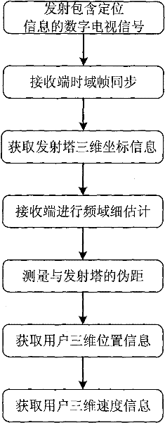
[0037] According to the method for accurate three-dimensional positioning using multi-carrier digital signals according to an embodiment of the present invention, the steps are as follows figure 1 As shown, it includes: digital TV transmitting towers transmit multi-carrier digital TV signals with positioning information; the receiving end first performs time-domain frame synchronization to find the starting position of multi-carrier digital TV signal frames, and demodulates common digital TV The signal frame or system information obtains the two-dimensional or three-dimensional coordinate information of the transmission tower, and then the receiving end performs a fine est...


PUM


Abstract

The invention discloses a TOA positioning estimation method and a precise positioning method based on the estimation method. The positioning method includes the steps of: transmitting a multi-carrier digital television signal with positioning information, the positioning information includes two-dimensional or three-dimensional coordinate position information and positioning data of the transmitting end, and the positioning data is a known sequence; performing a multi-carrier digital television signal received Time-domain frame synchronization, so as to obtain a rough estimate of the transmission delay; intercept the positioning data, use the TOA positioning estimation method to calculate a fine estimate of the transmission delay, and then obtain an estimated value of the distance between the receiving end and the transmitting end; find the distance between the receiving end and the transmitting end After estimating the distance between multiple transmitters, use the positioning algorithm to calculate the two-dimensional or three-dimensional position information and two-dimensional or three-dimensional velocity information of the user's location based on the estimated distance and two-dimensional or three-dimensional coordinate position information. The invention has the advantages of simple algorithm, fast positioning update speed, strong system compatibility, wide application range and accurate positioning.

Description

technical field [0001] The invention relates to the field of wireless digital transmission, in particular to a TOA positioning estimation method and a precise positioning method based on the estimation method. Background technique [0002] With the rapid increase of military and civilian demands for wireless precise positioning, wireless positioning technology has received extensive attention in recent years and has made great progress and development. The GPS (Global Positioning System, Global Positioning System) of the United States, the Galileo (Galileo) system of Europe, the GLONASS system of Russia, and the "Beidou" positioning system of my country, etc. (see document [1] E.D.Kaplan, C.Hegarty, "Understanding GPS: Principles and Applications, Second Edition, "Boston, USA: Artech House Publishers, 2005), with the huge advantages of wide-area coverage, it pushes radiolocation technology to a new level. [0003] However, there are still many shortcomings in the satellite p...

Claims


Application Information

Patent Timeline
Patent Type & Authority Patents(China)
IPC IPC(8): H04W64/00H04L27/26
Inventor 王昭诚戴凌龙王军杨知行
Owner TSINGHUA UNIV
Features
  • R&D
  • Intellectual Property
  • Life Sciences
  • Materials
  • Tech Scout
  • Unparalleled Data Quality
  • Higher Quality Content
  • 60% Fewer Hallucinations
Learn More