Real-time road condition acquiring, analyzing and back-feeding and intelligent transportation integrated service system

A technology of real-time road conditions and comprehensive services, applied in the fields of vehicle dispatching, intelligent traffic management, vehicle navigation, road planning, and logistics distribution. Convenient and quick driving, accurate prediction, and wide collection sources

Inactive Publication Date: 2010-07-14
戴磊
View PDF0 Cites 161 Cited by
  • Summary
  • Abstract
  • Description
  • Claims
  • Application Information

AI Technical Summary

Problems solved by technology

[0007] The accuracy and current status of electronic maps are the basis of navigation systems. Traditional navigation systems generally use terminals to deploy electronic maps, and update them through periodic manual purchase of update data CDs or downloads from provider websites. The method is cumbersome and the update frequency is low, so the current situation is not particularly good; some navigation systems put the electronic map on the server. If the server is updated in ti

Method used


Image

  • Real-time road condition acquiring, analyzing and back-feeding and intelligent transportation integrated service system
  • Real-time road condition acquiring, analyzing and back-feeding and intelligent transportation integrated service system
  • Real-time road condition acquiring, analyzing and back-feeding and intelligent transportation integrated service system

Examples


Embodiment 1

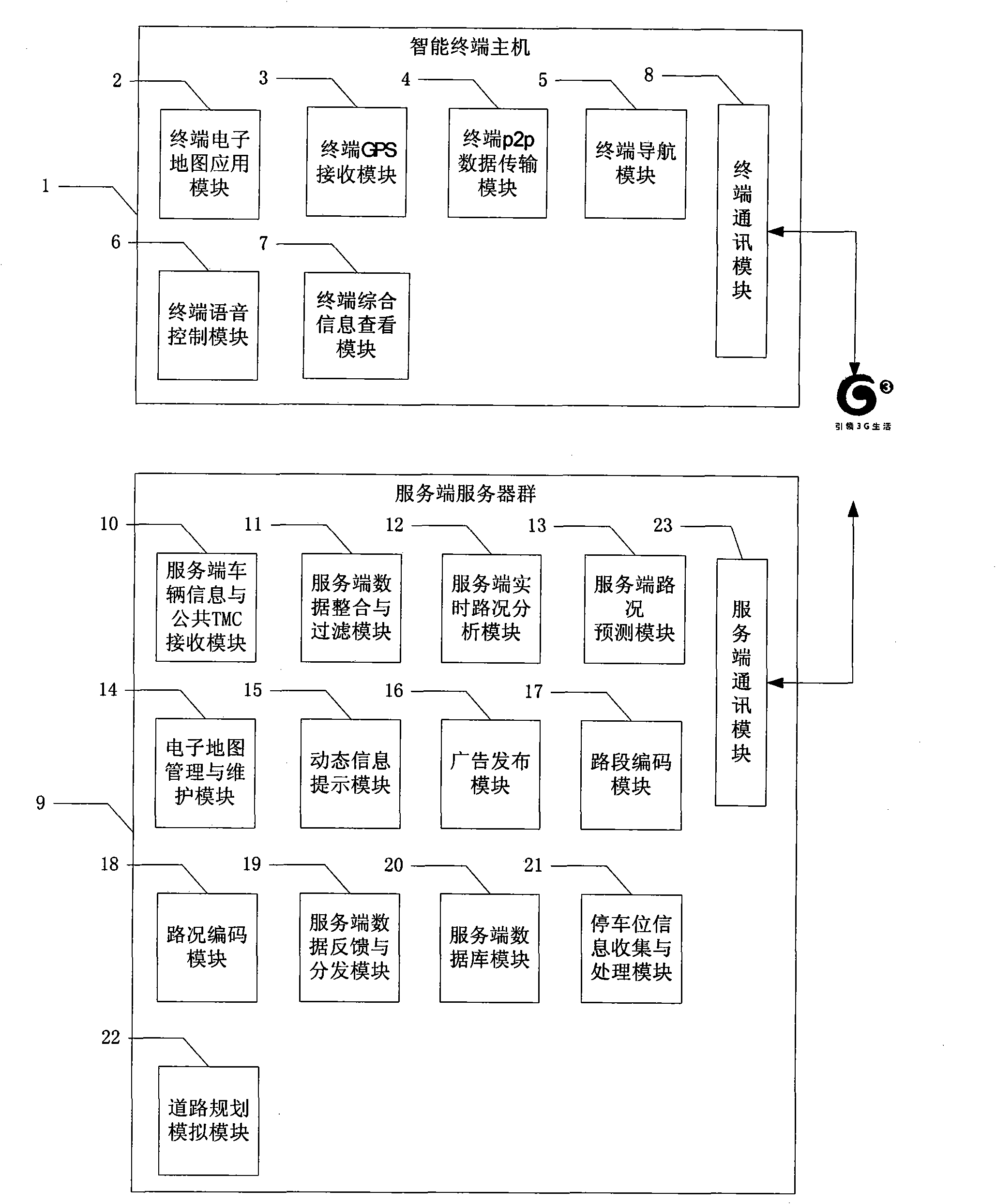
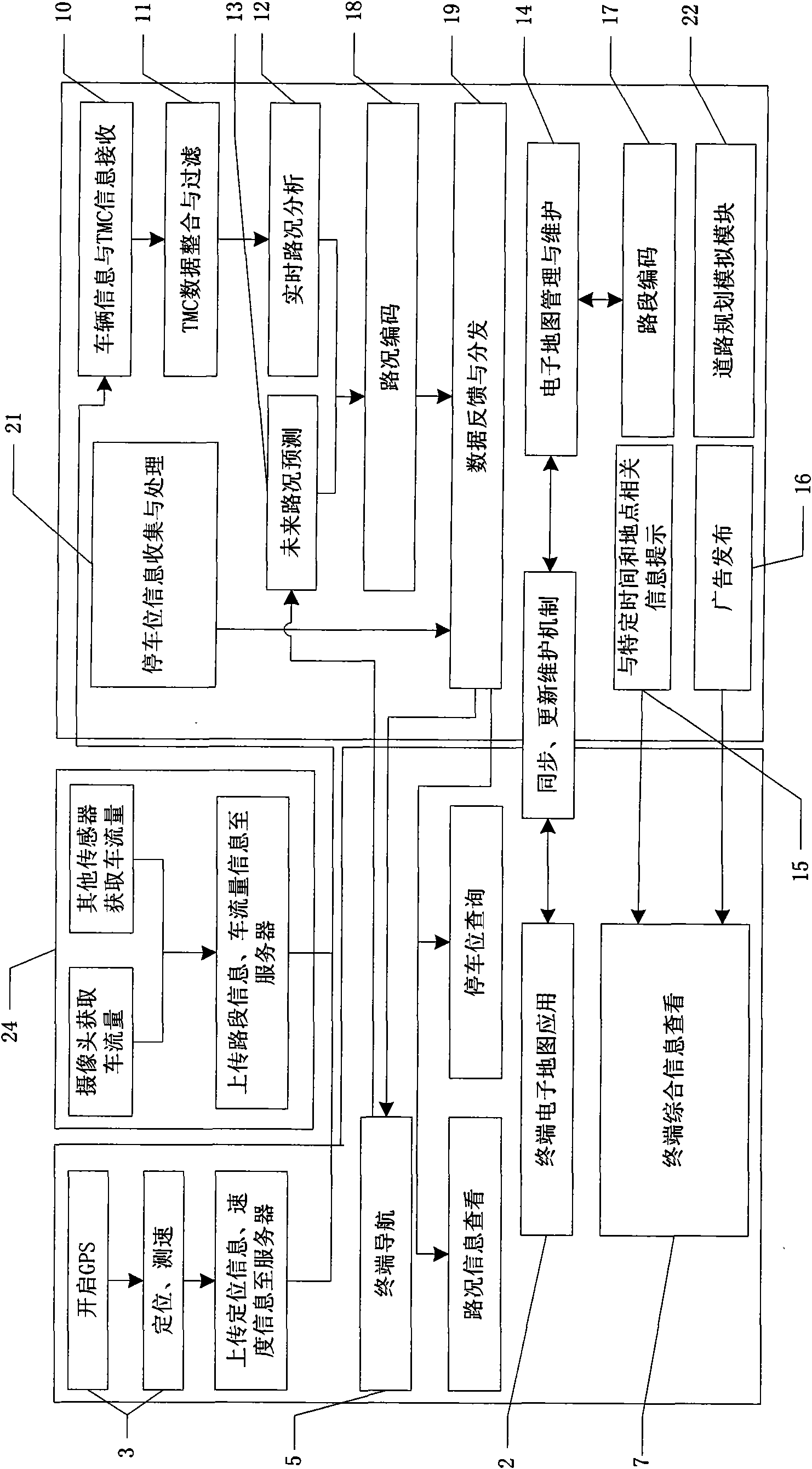
[0104] This implementation case system (hereinafter referred to as the system) generally adopts the C / S structure and includes three parts (see figure 1 ): network environment, user terminal, server.

[0105] First of all, there must be a network environment to support the communication and data transmission between the user terminal and the server. This system uses a mobile 3G network.

[0106] The user terminal mainly interacts with the user directly, and it mainly includes an intelligent terminal host, a terminal GPS receiving module, a wireless mobile network communication module, a terminal p2p data transmission module, a terminal voice control module, a terminal navigation module, and a terminal comprehensive information viewing module, etc. It is mainly used to realize terminal traffic information collection, traffic information viewing, information query, path analysis, intelligent navigation, etc.

[0107] The server is the background support of the system, which mai...

Embodiment 2

[0120] A certain city has 3,000 kilometers of urban roads (6,000 kilometers in both directions), divided into 5,000 road sections, and 1.3 million motor vehicles. The server has received a set of public TMC data (covering 1,200 kilometers of urban roads) provided by the transportation department, and 12,000 vehicle dynamic data sent by the terminal of this system. In the last 3 minutes, 12,000 vehicles should send 720,000 vehicle data information, after analysis and processing, filtered out 32,000 vehicle parking information (excluding waiting for red lights at intersections), and the remaining 688,000 vehicle data information covered a total of 4,800 kilometers of urban roads (separated by two-way) , plus the public TMC data provided by the transportation department, it is able to cover 5,200 kilometers of urban roads, with a coverage rate of 87%. Coupled with the historical data of the previous 15 minutes, it can reach nearly 100% coverage.

[0121] The server sends adverti...


PUM


Abstract

The invention discloses a real-time road condition acquiring, analyzing and back-feeding and intelligent transportation integrated service system, which is divided into two parts of an intelligent terminal host and a server-side server farm. The intelligent terminal host consists of electronic map application, GPS receiving, p2p data transmission, navigation, voice control, general message checking and a communication module; the server-side server farm consists of vehicle information and public TMC receiving, data integration and filtration, road condition analysis, road condition forecast, electronic map management and maintenance, dynamic information prompt, advertising publishing, data feedback and publishing, a server-side data base, parking space information collection and treatment, road section codes, road condition codes, road planning analog and a communication module. The invention has wide road condition information acquisition source, strong data handling capacity, can carry out highly-accurate real-time road condition analysis, road condition information forecast, path planning navigation, information inquiry and the like, and can be widely applied in the fields of road planning, intelligent traffic management, vehicle navigation, car scheduling and the like.

Description

technical field [0001] The invention relates to the fields of road planning, intelligent traffic management, vehicle navigation, vehicle dispatching, and logistics distribution, and in particular relates to a real-time road condition collection, analysis and feedback and intelligent traffic comprehensive service system. Background technique [0002] With the continuous development and improvement of the GPS satellite positioning system, it is becoming more and more civilian. Especially in recent years, it has been widely used in vehicle navigation systems. [0003] Looking at the current popular navigation systems in society, they are generally divided into one-click version and C / S version. All functions of the stand-alone version are implemented on the client side, including: navigation terminal host, main program, electronic map, GPS receiver, etc. When working, open the program, start the electronic map, and turn on the GPS receiver at the same time, the user can brows...

Claims


Application Information

Patent Timeline
IPC IPC(8): G08G1/00G08G1/0967G08G1/0969G08G1/14
Inventor 戴磊
Owner 戴磊
Why Eureka
Try Eureka