Atmospheric correction and regional mineral map spotting method utilizing multi-scene ASTER (Advanced Spaceborne Thermal Emission and Reflection Radiometer) remote sensing data

A technology of atmospheric correction and remote sensing data, applied in the field of geological remote sensing, can solve the problems of atmospheric correction algorithm multi-view data mosaic and splicing difficulties, dual-band calculation method can not give full play to the advantages of ASTER data, and achieve the effect of eliminating different atmospheric parameters

Inactive Publication Date: 2010-10-27
CHINA AERO GEOPHYSICAL SURVEY & REMOTE SENSING CENT FOR LAND & RESOURCES
View PDF5 Cites 18 Cited by
  • Summary
  • Abstract
  • Description
  • Claims
  • Application Information

AI Technical Summary

Problems solved by technology

[0005] The purpose of the present invention is to solve the complexity of the official atmospheric correction algorithm of ASTER data and the difficulty of multi-view data mosaic and splicing, and the dual-band calculation method can not give full play to the advantages of ASTER data. Compared with ETM / ETM + Data, with more bands, proposes a multi-view ASTER data atmospheric correction and regional mineral mapping method, which can not only complete the atmospheric correction of ASTER data without the need for atmospheric parameters, but also effectively eliminate multi-view Differences in mineral mapping results between data due to different atmospheric parameters

Method used


Image

  • Atmospheric correction and regional mineral map spotting method utilizing multi-scene ASTER (Advanced Spaceborne Thermal Emission and Reflection Radiometer) remote sensing data
  • Atmospheric correction and regional mineral map spotting method utilizing multi-scene ASTER (Advanced Spaceborne Thermal Emission and Reflection Radiometer) remote sensing data
  • Atmospheric correction and regional mineral map spotting method utilizing multi-scene ASTER (Advanced Spaceborne Thermal Emission and Reflection Radiometer) remote sensing data

Examples


Embodiment Construction

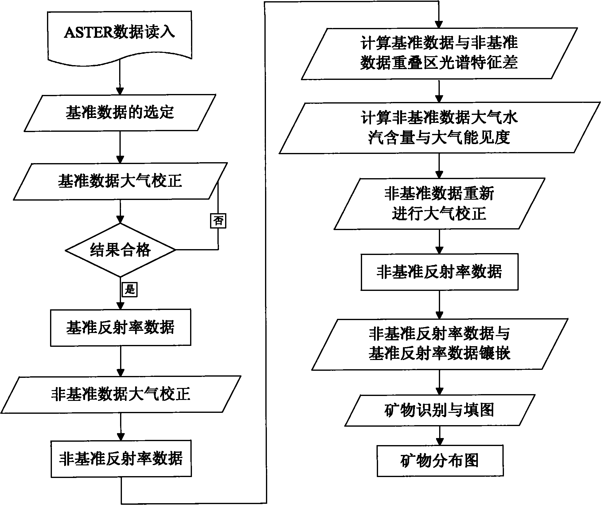
[0044] In order to better illustrate the multi-view ASTER remote sensing data atmospheric correction and regional mineral mapping method involved in the present invention, the three-view ASTER in the East Tianshan area of ​​Xinjiang was used to carry out mineral mapping. The realization process is as follows figure 1 As shown, the specific steps are as follows:

[0045] (1) Reading in hyperspectral data

[0046] Read into the ASTER of the three sceneries in East Tianshan, Xinjiang, and the original data size is 2827 (rows) × 2513 (columns) × 9 (bands) (the first scene), 2797 (rows) × 2475 (columns) × 9 (bands) ( The second scene), 2826 (rows) × 2512 (columns) × 9 (bands) (the third scene).

[0047] (2) Selection of benchmark data

[0048] The first scene is selected as the reference data.

[0049] (3) Atmospheric correction of benchmark data

[0050] From the surface to the top of the atmosphere 0-100km, the atmosphere is divided into 36 layers, and the conditions of each ...


PUM


Abstract

The invention relates to an atmospheric correction and regional mineral map spotting method utilizing multi-scene ASTER (Advanced Spaceborne Thermal Emission and Reflection Radiometer) remote sensing data, comprising the following nine steps of: (1) reading in ASTER data; (2) selecting reference data, wherein one-scene data is selected from multi-scene data as a reference for atmospheric correction; (3) carrying out the atmospheric correction on the reference data to obtain reference reflectivity data; (4) carrying out atmospheric correction on non-reference data to obtain non-reference reflectivity data; (5) calculating the overlay region spectral characteristic difference of the reference reflectivity data and the non-reference reflectivity data; (6) calculating the atmospheric water vapor content and the atmospheric visibility of the non-reference data; (7) newly carrying out the atmospheric correction on the non-reference data by utilizing the calculated atmospheric water vapor content and the atmospheric visibility to obtain non-reference reflectivity data; (8) carrying out inlaying treatment on the multi-scene reflectivity data including the reference data and the non-reference data; and (9) carrying out mineral identification and map spotting by utilizing spectral indexes. The method effectively eliminates inlaid gaps among the multi-scene data, thereby realizing the regional mineral map spotting.

Description

technical field [0001] The invention belongs to geological remote sensing technology, in particular to a method for atmospheric correction of multi-view ASTER remote sensing data and regional mineral mapping. Background technique [0002] ASTER data is ETM / ETM + The new generation of earth observation satellite remote sensing data after the data. This data can identify altered minerals related to the metallogenic process of metal deposits, such as sericite, kaolinite, chlorite, epidote, etc., and has great potential for application in resource exploration. However, the data processing is complicated, and traditional ETM / ETM + Data processing methods have been difficult to meet the requirements. Data processing mainly consists of two steps: 1) Atmospheric correction; 2) Mineral identification and mapping. [0003] The official algorithm for atmospheric correction of ASTER data released by the ASTER sensor development team is to first use the MODIS data in the same phase t...

Claims


Application Information

Patent Timeline
Patent Type & Authority Applications(China)
IPC IPC(8): G01N21/31G01N21/55G01S17/88
Inventor 闫柏琨王润生杨苏明
Owner CHINA AERO GEOPHYSICAL SURVEY & REMOTE SENSING CENT FOR LAND & RESOURCES
Why Eureka
Try Eureka