
Mirror surface projection method for precisely determining orbit of geostationary orbit satellite

A geostationary orbit and precise orbit determination technology, applied in positioning, measuring devices, instruments, etc., can solve the problems of difficult solution and separation of system errors, large investment, and difficult determination of orbit, so as to improve the accuracy of orbit determination and expand observation range, the effect of reducing the number of layouts

Inactive Publication Date: 2010-11-10
INST OF GEODESY & GEOPHYSICS CHINESE ACADEMY OF SCI
View PDF1 Cites 2 Cited by
  • Summary
  • Abstract
  • Description
  • Claims
  • Application Information

AI Technical Summary

Problems solved by technology

Its disadvantages are that it has high requirements for station layout and observation equipment, large investment, and its orbit determination accuracy cannot meet the needs of satellite navigation systems.
The disadvantage of this type of orbit determination method is that there are certain uncertain factors in GPS applications, and its orbit determination accuracy cannot meet the needs of satellite navigation systems.
The disadvantage of this type of method is that its orbit determination accuracy cannot meet the needs of satellite navigation systems
The disadvantage is that the accuracy of orbit determination cannot meet the needs of satellite navigation systems
[0009] Since the geostationary satellite orbit is 36,000 kilometers away from the ground, the satellite's opening angle to the entire earth is less than 18 degrees. To make full use of the satellite's opening angle to the entire earth, the maximum distance between ground stations should be close to the diameter of the earth. The difficulty is high, which makes the observation geometric structure of geostationary satellites poor; secondly, because the positions of geostationary satellites and ground tracking stations are relatively static, the geometric changes of the stations are small, and the amount of information brought by increasing the observation time is limited, making the clock It is difficult to solve and separate some system errors, such as error and station deviation
The accuracy of precise orbit determination of geostationary orbit satellites is also difficult to meet the needs of navigation and positioning, and the orbit during maneuvering is even more difficult to determine with high accuracy

Method used


Image

  • Mirror surface projection method for precisely determining orbit of geostationary orbit satellite
  • Mirror surface projection method for precisely determining orbit of geostationary orbit satellite

Examples


Embodiment 1

[0023] The specular projection method for precise orbit determination of geostationary satellites consists of the following steps:

[0024] 1. Calculate the projection surface required for the implementation of the mirror projection method

[0025] 1.a. Solve the orbital plane of the geostationary orbit satellite by geometric method or dynamic method, and use the orbital plane as the projection plane;

[0026] 2. Using mirror projection to form virtual observation stations and their corresponding virtual observation values

[0027] 2.a. Perform mirror projection on each observation station, that is, take the orbital plane as a symmetrical plane, and set up a virtual observation station at a place symmetrical to each observation station;

[0028] 2.b. The observation value of each virtual observation station adopts the observation value of its corresponding observation station.

[0029] 3. Combining the observation values ​​of actual observation stations and virtual observati...

Embodiment 2

[0031] Utilize the standard orbit of the satellite, simulate 5 ground monitoring stations to the multi-day observation data of the geostationary orbit satellite, the observation noise obeys normal distribution N (0, 1), 10 meters of satellite clock difference, adopt the step of embodiment one to determine rail.

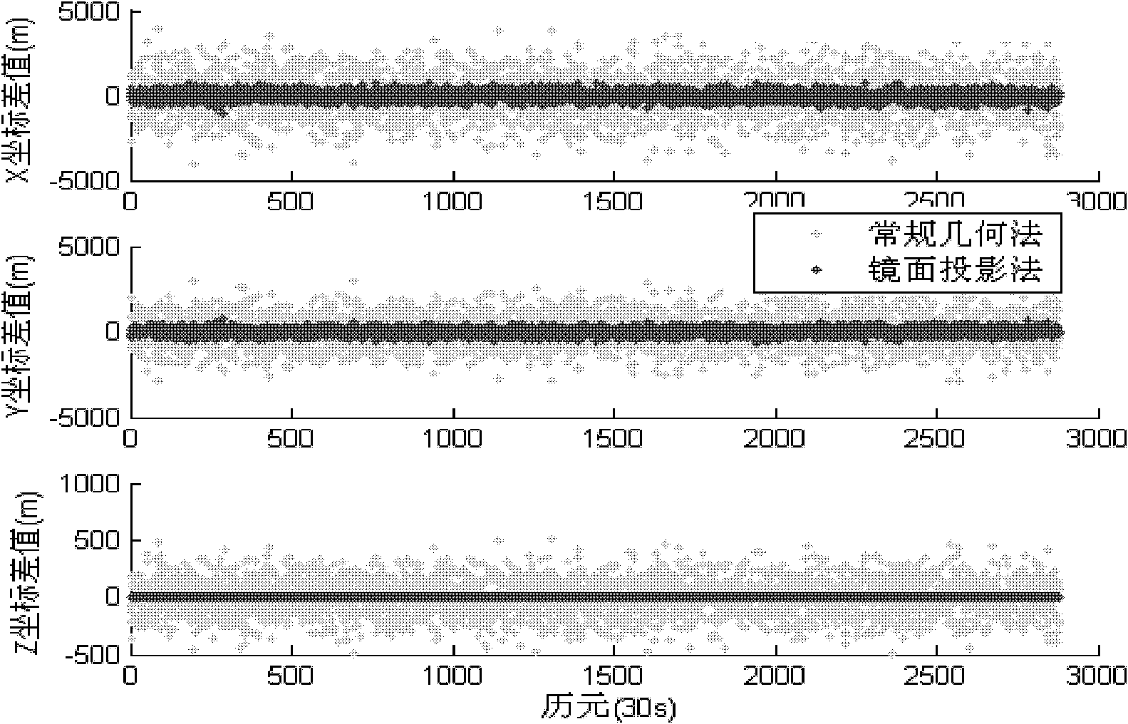
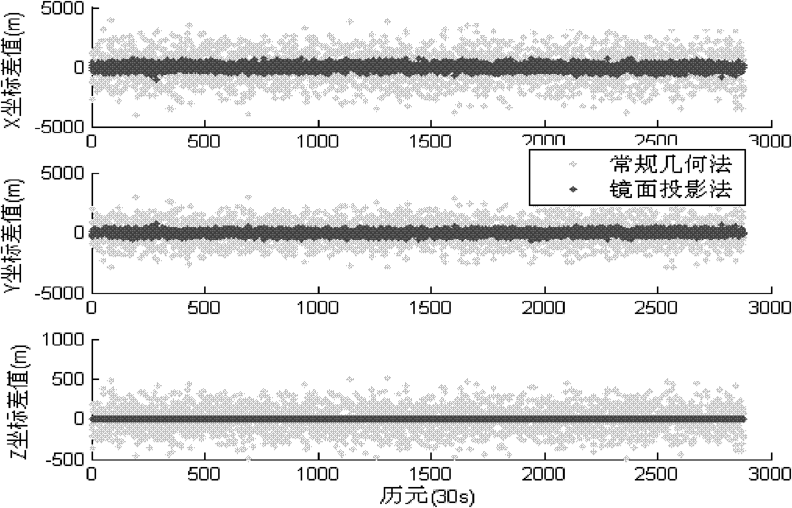
[0032] figure 1 It is the comparison of the difference between the orbital parameters of geostationary orbit satellites calculated by the geometric method without the specular projection method and the geometric method with the specular projection method and the true value. Among them, the horizontal axis is the number of epochs (30-second interval), and the three vertical axes are the difference between the calculated value and the true value in the X, Y, and Z directions respectively; the light-colored points in the figure are the calculated results without using the mirror projection method , and the dark points are the calculation results after using the mirror p...

Embodiment 3

[0034] Using the standard orbit of the satellite, the one-day observation data of the geostationary orbit satellite by five ground monitoring stations are simulated. For the convenience of dealing with the problem, the observation error term considers observation noise, troposphere, ionosphere and satellite clock error simulated by quadratic terms. The satellite's perturbation item considers multi-body perturbation, solar light pressure, and empirical force. The steps in Embodiment 1 are used for orbit determination.

[0035] When the mirror projection method is not used, the difference between the initial orbital elements calculated by the dynamic method and the true value is 0.5020 meters in the X direction, 0.4097 meters in the Y direction, and 1.6120 meters in the Z direction; The difference between the calculated initial orbit elements and the true value is 0.1402 meters in the X direction, 0.2335 meters in the Y direction, and 0.0262 meters in the Z direction; it can be...


PUM


Abstract

The invention discloses a mirror surface projection method for precisely determining an orbit of a geostationary orbit satellite and relates to the accurate orbit determination of the geostationary orbit satellite by a regional observation station. The mirror surface projection method comprises the critical steps of selection of a projection surface, establishment of a virtual observation station and selection of observation value of the virtual observation station. Due to the establishment of the virtual observation station, observation data is doubled, and the precision of a parameter is improved, wherein the parameter is evaluated by an orbit parameter evaluation observation equation set which is acquired based on the fact that the observation data is doubled. As is shown by a figure, the difference between the result evaluated by the mirror surface projection method and a truth value is obviously less than that between the result not evaluated by the mirror surface projection method and the truth value.

Description

technical field [0001] The invention relates to the precise orbit determination of geostationary orbit satellites, in particular to the precise orbit determination of geostationary orbit satellites by using regional observation stations. Background technique [0002] The second-generation Beidou navigation, positioning and timing system under construction in my country includes a certain number of geostationary orbit satellites. The Chinese regional positioning, navigation and communication system independently designed by our country is also mainly composed of a certain number of geostationary orbit satellites. India's IRNSS (IndianRegional Navigation Satellite System) plans to consist of 3 geostationary orbits and 4 inclined orbit geostationary satellites. Therefore, determining the orbit of geostationary satellites with high precision is an important link to ensure the performance and availability of the new generation of navigation and positioning systems. [0003] At ...

Claims


Application Information

Patent Timeline
Patent Type & Authority Applications(China)
IPC IPC(8): G01S5/00
Inventor 欧吉坤刘吉华钟世明彭碧波
Owner INST OF GEODESY & GEOPHYSICS CHINESE ACADEMY OF SCI
Learn More