Digital line graph mapping method

A technology of digital line drawing and mapping method, which is applied in the field of surveying and mapping remote sensing, can solve the problems of long project cycle, heavy engineering survey workload, low degree of automation, etc., to achieve deepening and application depth and breadth, and expand application depth and breadth , good economic and social benefits

Active Publication Date: 2011-08-10
星际空间(天津)科技发展有限公司
View PDF3 Cites 28 Cited by
  • Summary
  • Abstract
  • Description
  • Claims
  • Application Information

AI Technical Summary

Problems solved by technology

[0003] (1) There are many shortcomings in engineering survey, such as heavy workload, high project cost, long cycle and high labor intensity, and it is not economically feasible in large-scale digital line drawing mapping projects;
[0004] (2) The traditional aerial photogrammetry method needs to deploy a large number of field image control points, the degree of automation of stereoscopic mapping is low, the production efficiency is low, the project cycle is long, and the accuracy of mapping is poor in mountainous areas, especially in forested areas. There are great limitations in map mapping
[0005] Therefore, when methods such as engineering surveying and traditional aerial photogrammetry are used in the process of digital line drawing mapping, it will inevitably bring a lot of trouble and low efficiency.
Therefore, the digital line drawing mapping method in the prior art has many shortcomings such as low degree of automation, low production efficiency, high project cost, long development cycle and low product accuracy.

Method used


Image

  • Digital line graph mapping method
  • Digital line graph mapping method
  • Digital line graph mapping method

Examples


Embodiment Construction

[0053] In order to make the object, technical solution and advantages of the present invention clearer, the implementation manner of the present invention will be further described in detail below in conjunction with the accompanying drawings.

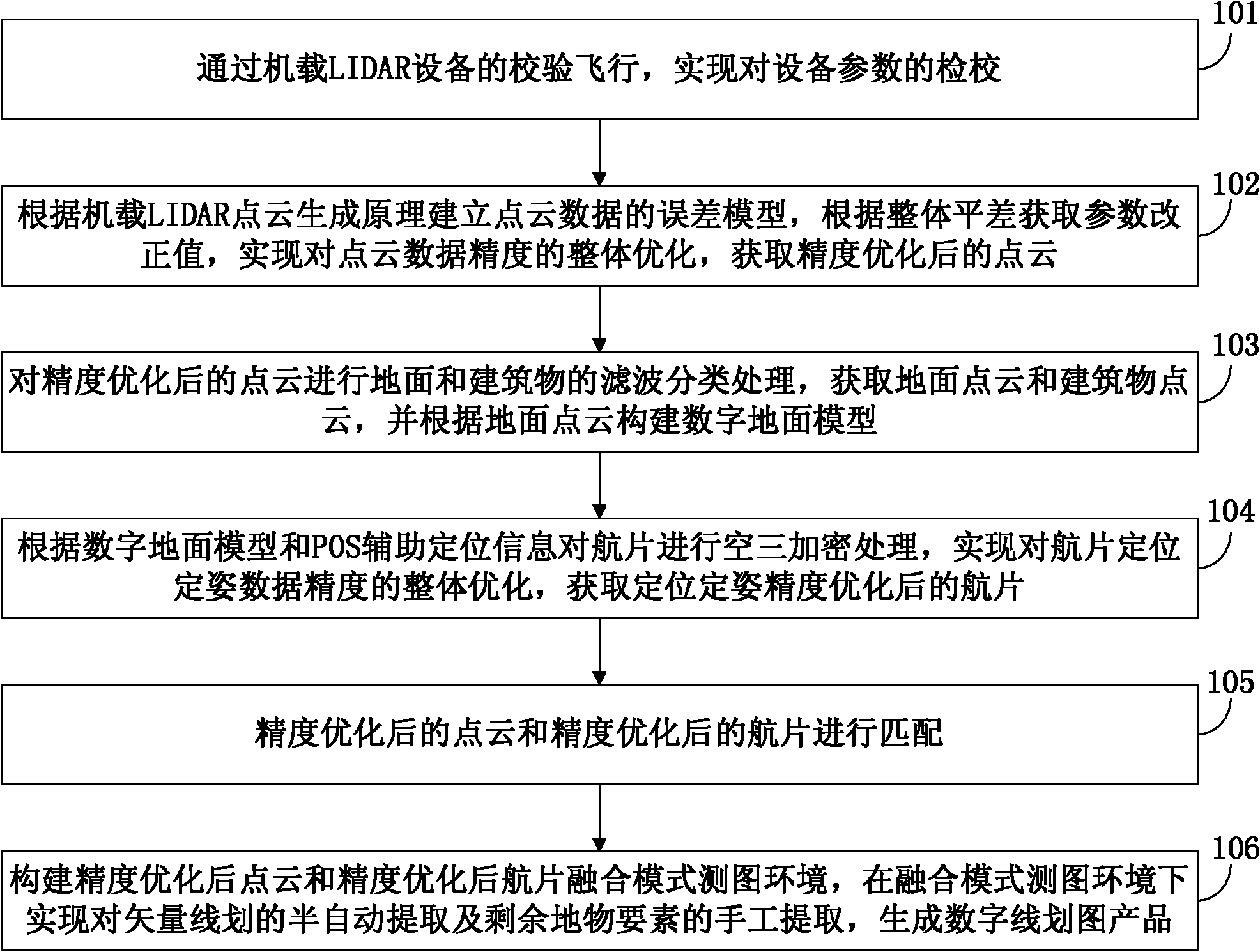
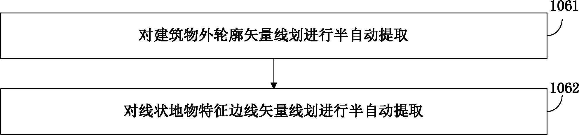
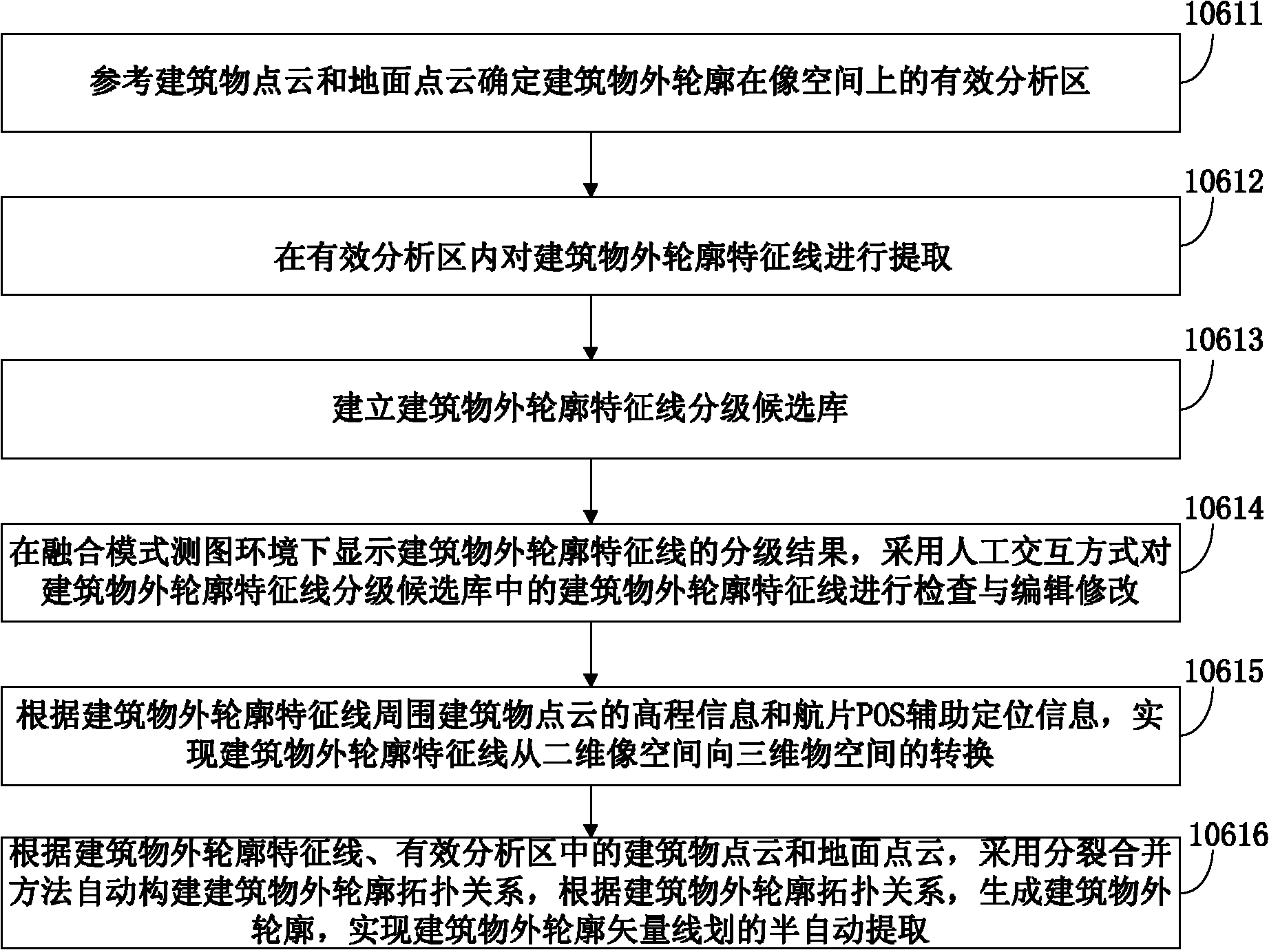
[0054] In order to improve the quality of digital line drawing mapping products, improve the level of automation, improve production efficiency, reduce project costs, and shorten the development cycle, the embodiment of the present invention provides a digital line drawing mapping method, see figure 1 , see the description below:

[0055] 101: Through the verification flight of the airborne LIDAR (Light Detection And Ranging, laser radar) equipment, the verification of the equipment parameters is realized;

[0056] Among them, the main components of the airborne LIDAR equipment are laser sensors, digital cameras and POS positioning and attitude determination systems. The laser sensor needs to check the three parameters of heading (yaw...


PUM


Abstract

The invention discloses a digital line graph mapping method, relating to the fields of mapping and remote sensing. The digital line graph mapping method comprises the following steps of: verifying flight by using onboard LIDAR (Laser Intensity Direction and Ranging) equipment to realize calibration of equipment parameters; establishing a point cloud data error model according to an onboard LIDAR point cloud generation principle, acquiring a parameter correction value according to overall adjustment to realize integral accuracy optimization for point cloud data, and acquiring a point cloud with optimized accuracy; carrying out filtering and sorting treatment on the ground and buildings, acquiring a ground point cloud and a building point cloud, and establishing a digital ground model according to the ground point cloud; carrying out aerial triangulation encryption on an air photo according to the digital ground model and POS (Position and Orientation System) auxiliary positioning information to realize integral accuracy optimization for fixed-position and fixed-attitude data of the air photo, and acquiring the air photo with optimized accuracy; accurately matching the point cloud with the optimized accuracy and the air photo with the optimized accuracy; and establishing a mapping environment of a point cloud and air photo fused mode, realizing semi-automatic extraction of vector lines and total-manual extraction of residual ground feature elements in the fused mode mapping environment, and generating a digital line graph product.

Description

technical field [0001] The invention relates to the field of surveying and mapping remote sensing, in particular to a digital line drawing mapping method. Background technique [0002] The digital line drawing mapping method in the prior art mainly adopts engineering surveying and traditional aerial photogrammetry methods, but these traditional technical methods all have obvious shortcomings and deficiencies: [0003] (1) There are many shortcomings in engineering survey, such as heavy workload, high project cost, long cycle and high labor intensity, and it is not economically feasible in large-scale digital line drawing mapping projects; [0004] (2) The traditional aerial photogrammetry method needs to deploy a large number of field image control points, the automation degree of stereo mapping is low, the production efficiency is low, the project cycle is long, and the mapping accuracy is poor in mountainous areas, especially in forested areas. There are significant limit...

Claims


Application Information

Patent Timeline
Patent Type & Authority Applications(China)
IPC IPC(8): G01C11/04
Inventor 窦华成邓世军江宇李建平王力程良勇
Owner 星际空间(天津)科技发展有限公司
Why Eureka
Try Eureka