Remote sensing inversion method for land surface evapotranspiration of arid and semi-arid regions

A remote sensing inversion, semi-arid technology, applied in the field of surface evapotranspiration remote sensing inversion, can solve the problems of limitations, differences, and less research on remote sensing inversion, and achieve the effect of reducing requirements, good applicability and pertinence

Inactive Publication Date: 2011-11-23
NANJING UNIV OF INFORMATION SCI & TECH
View PDF0 Cites 42 Cited by
  • Summary
  • Abstract
  • Description
  • Claims
  • Application Information

AI Technical Summary

Problems solved by technology

However, most studies are limited to humid areas, and there are relatively few remote sensing inversion studies on surface evapotranspiration in arid and semi-arid areas.
Existing studies on arid and semi-arid regions mainly use the existing SEBAL model for

Method used


Image

  • Remote sensing inversion method for land surface evapotranspiration of arid and semi-arid regions
  • Remote sensing inversion method for land surface evapotranspiration of arid and semi-arid regions
  • Remote sensing inversion method for land surface evapotranspiration of arid and semi-arid regions

Examples


Embodiment Construction

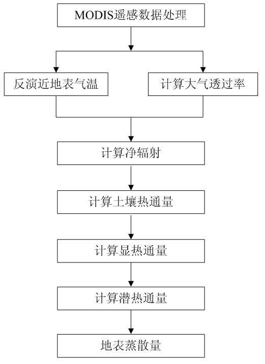
[0052] Below in conjunction with accompanying drawing, technical scheme of the present invention is described in further detail:

[0053] (1) EOS / MODIS remote sensing data processing

[0054] The EOS / MODIS remote sensing data used in the present invention include land cover products, monthly synthetic vegetation index products, 8-day synthetic surface temperature products and 16-day synthetic albedo products. Firstly, the spatial projection transformation is performed on all the data and unified into the same spatial reference frame; then the vegetation index and surface temperature are declouded by using the time series harmonic fitting method to eliminate the data missing problem caused by cloud coverage. The solar zenith angle data at the time of imaging were extracted from the vegetation index products; the surface temperature and albedo data were then synthesized on a monthly basis to match the NDVI data.

[0055] (2) Inversion of near-surface air temperature and calcula...


PUM


Abstract

The invention discloses a remote sensing inversion method for land surface evapotranspiration of arid and semi-arid regions. The method comprises the steps of: acquiring and processing EOS/MODISE (Earth Observing System/Moderate-resolution Imaging Spectroradiometer) remotely sensed data; performing the inversion of near-surface temperature and computing atmospheric transmittance; obtaining a land surface latent heat flux by solving a net radiation quantity, a soil heat flux and a sensible heat flux according to a land surface energy balance equation; and figuring out land surface evapotranspiration data according to the land surface latent heat flux. According to the invention, aiming at the characteristics of rare meteorological stations in the arid region of Northwest China, a near-surface temperature inversion model and an atmospheric transmittance model both based on remotely sensed data are established, and the temperature obtained by the remote sensing inversion is used for participating in the computation instead of the observed temperatures of the stations; therefore, requirements on meteorological and other observation data are reduced.

Description

technical field [0001] The invention relates to a remote sensing inversion method for surface evapotranspiration, in particular to a technical method for inverting surface evapotranspiration by mainly using satellite remote sensing data for the characteristics of the scarcity of meteorological observation stations in arid and semi-arid areas. Resource monitoring and management. Background technique [0002] Surface evapotranspiration is a key link in the water cycle process and a major item in energy balance. A clear understanding of the temporal and spatial variation characteristics of evapotranspiration is of outstanding scientific value for understanding the water cycle and energy balance processes in a large scale, and it is helpful for in-depth study of land surface processes and correct assessment of the impact of climate and human activities on ecosystems. Obtaining accurate surface evapotranspiration data can provide important reference information for regional wate...

Claims


Application Information

Patent Timeline
IPC IPC(8): G01N33/24
Inventor 徐永明赵巧华白淑英孙德勇
Owner NANJING UNIV OF INFORMATION SCI & TECH
Why Eureka
Try Eureka