Geographic Information Internet of Things System and Application Based on Cloud Computing

An Internet of Things system and technology of the Internet of Things, applied in the field of computer networks, can solve problems such as intermittent logistics data, Internet sharing, and inability to draw

Inactive Publication Date: 2011-11-30
SICHUAN UNIV
View PDF2 Cites 14 Cited by
  • Summary
  • Abstract
  • Description
  • Claims
  • Application Information

AI Technical Summary

Problems solved by technology

[0007] The existing logistics positioning and tracking technology is based on non-radio frequency identification (RFID) technology, and the data information after logistics sampling cannot be shared by the Internet
It is precisel

Method used


Image

  • Geographic Information Internet of Things System and Application Based on Cloud Computing
  • Geographic Information Internet of Things System and Application Based on Cloud Computing
  • Geographic Information Internet of Things System and Application Based on Cloud Computing

Examples


example 1

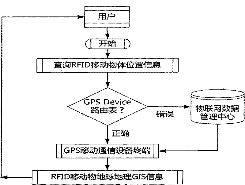
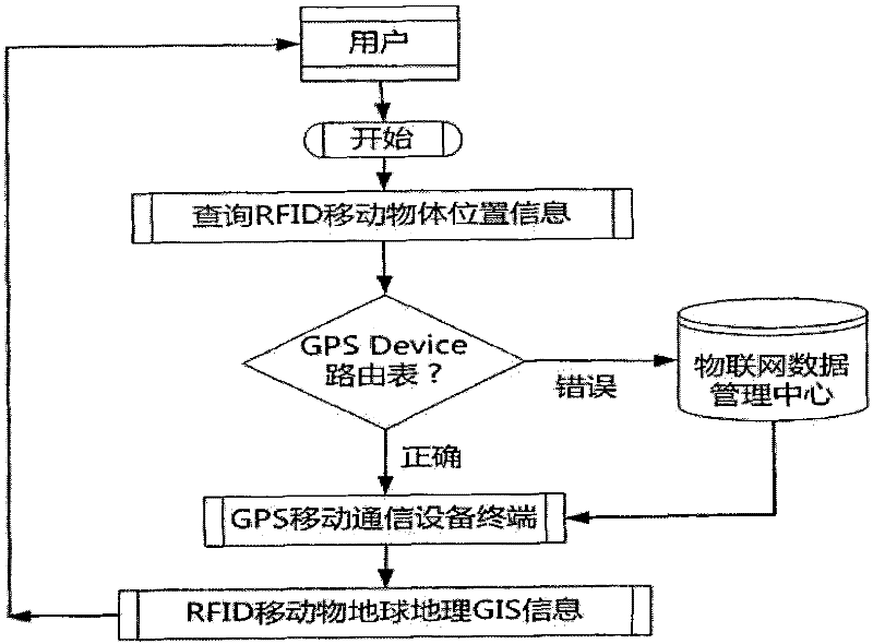
[0027] Paste radio frequency identification (RFID) electronic tags on any movable objects, such as express parcels, moving vehicles, envelopes, moving people, products on the production line, etc., and the GPS mobile communication equipment terminal is in the communication area of ​​RFID mobile objects Within the range, the GPS mobile communication device terminal uses physical radio frequency technology to sense that the RFID mobile object has entered the signal coverage area. At this time, the GPS mobile communication device terminal believes that the RFID mobile object can be located. Then the GPS mobile communication device terminal starts the GPS terminal system software, and manipulates the local GPS mobile communication device to obtain the real-time positioning data information of the earth satellite for the longitude and latitude of the device's location.

[0028] After the global positioning system mobile communication equipment terminal obtains the current GIS data s...

example 2

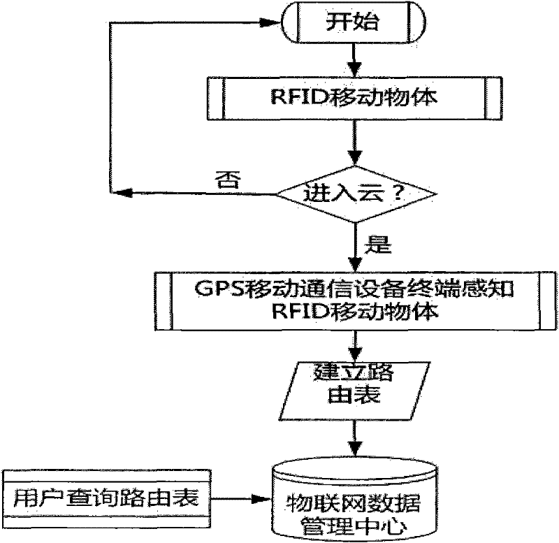
[0040] After RFID mobile objects enter the Internet of Things, RFID mobile objects enter the cloud as "cloud points". For a period of time thereafter, the RFID mobile object belongs to the cloud as a "cloud point". The Internet of Things is composed of infinitely many clouds, and each cloud has a central node. In the system architecture, the central node of the cloud is called "cloud heart", and the GPS mobile communication device terminal is used as the "cloud heart" of a cloud. When the cloud point enters the cloud, the entry and existence of the cloud point is intelligently perceived by Yunxin; when the cloud point leaves the predecessor cloud A and enters the successor cloud B, the cloud point is iteratively perceived by the successor cloud B.

[0041] The cloud center of each cloud is a GPS mobile communication device terminal, which connects to the earth satellite and obtains GIS data information such as the geographic longitude and latitude of the cloud, so the system c...


PUM


Abstract

The invention discloses a cloud computing-based radio frequency identification and mobile communication equipment to construct a geographic information Internet of Things system. Using radio frequency identification technology and global satellite positioning technology, and using mobile communication equipment terminals, wireless mobile communication networks can be rapidly deployed, solving the defects of traditional fixed networks that require wiring. In the communicable area, the mobile communication equipment terminal automatically senses any movable object with a radio frequency automatic identification electronic tag entering the sensing area, and intelligently automatically samples the logistics information. The collected data is connected to the Internet of Things and becomes part of the data of the Internet of Things. It is solved that the positioning information of moving objects in the Internet of Things is lagging and high-latency. The present invention can locate the current latest earth geographic location information of the moving object in real time at any time.

Description

technical field [0001] The invention relates to the technical field of computer networks, in particular to a cloud computing-based radio frequency identification and mobile positioning Internet of Things system and its application in logistics management. Background technique [0002] The Internet of Things is based on the computer Internet, which connects any item to the Internet for information exchange and communication, and realizes intelligent identification, positioning, tracking, monitoring and management. [0003] The existing logistics positioning and tracking technology is based on manual sampling, and the data information after sampling cannot be automatically shared on the Internet. The technology for logistics sampling now basically relies on the deployment of fixed networks, that is, fixed locations and fixed network equipment to collect specific logistics information. In some extreme environments such as remote places and complex road conditions, logistics Fo...

Claims


Application Information

Patent Timeline
IPC IPC(8): H04L29/08H04W4/02G06K7/00
Inventor 彭舰张飞
Owner SICHUAN UNIV
Why Eureka
Try Eureka