Industrial overhead pipeline measurement method based on ground LIDAR (Light Detection And Ranging)

A pipeline and industrial technology, applied in the field of industrial overhead pipeline measurement and 3D GIS display, can solve the problems of long time-consuming, cumbersome modeling process, low efficiency, etc., and achieve the effect of real and reliable data

Inactive Publication Date: 2012-06-13
南京市测绘勘察研究院股份有限公司
View PDF3 Cites 13 Cited by
  • Summary
  • Abstract
  • Description
  • Claims
  • Application Information

AI Technical Summary

Problems solved by technology

[0005] (1) The method of collecting three-dimensional coordinates at a discrete single point requires a large amount of point cloud data to describe the surface and entity structure of a complex structure. In order to ensure the integrity of the target structure, a large number of measurement points need to be collected, and the single-point positioning measurement method takes time to obtain data. Long, low efficiency, and the modeling process is very cumbersome and difficult to operate
[0006] (2) Using two-dimensional photogrammetry, there are inherent deformation errors of optical devices, insufficient depth of field, physical surface preprocessing, reference point setting, triangular plane misalignment, image data conversion and other uncertainties, and it is not suitable for complex Overhead pipeline testing
[0007] (3) The existing form of expression is relatively professional, lacks intuition, and requires high professional knowledge background requirements for map readers

Method used


Image

  • Industrial overhead pipeline measurement method based on ground LIDAR (Light Detection And Ranging)
  • Industrial overhead pipeline measurement method based on ground LIDAR (Light Detection And Ranging)
  • Industrial overhead pipeline measurement method based on ground LIDAR (Light Detection And Ranging)

Examples


Embodiment Construction

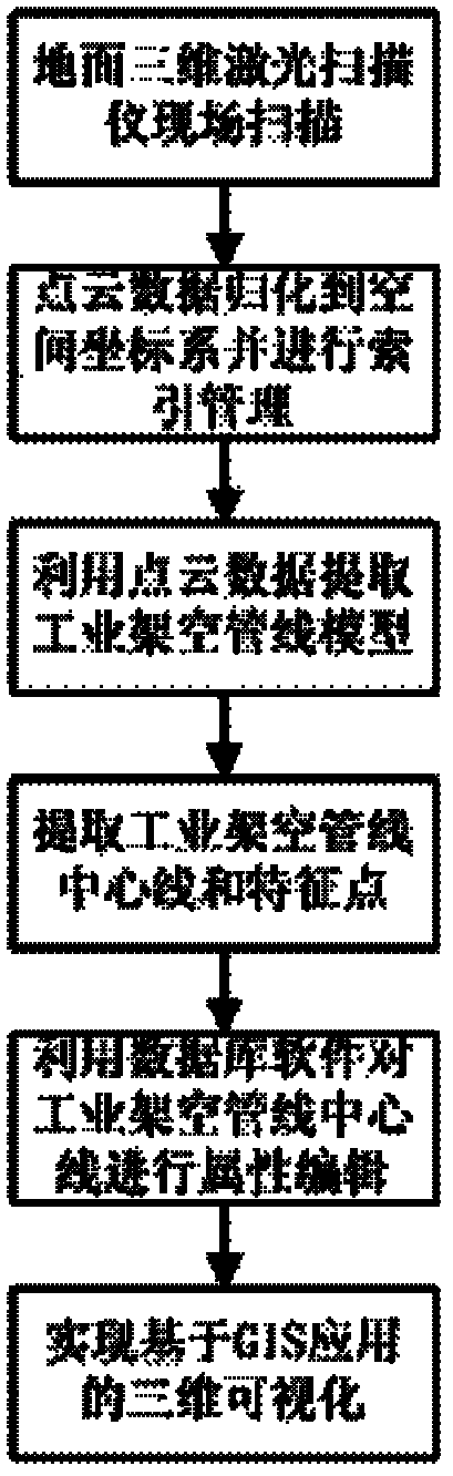
[0022] Below in conjunction with accompanying drawing and specific embodiment, further illustrate the present invention, should be understood that these embodiments are only for illustrating the present invention and are not intended to limit the scope of the present invention, after having read the present invention, those skilled in the art will understand various aspects of the present invention Modifications in equivalent forms all fall within the scope defined by the appended claims of this application.

[0023] Such as figure 1 As shown, the measurement method of industrial overhead pipelines based on ground LIDAR, the specific steps are as follows:

[0024] The first step: use the ground 3D laser scanner to complete the collection of 3D point cloud data of industrial pipelines.

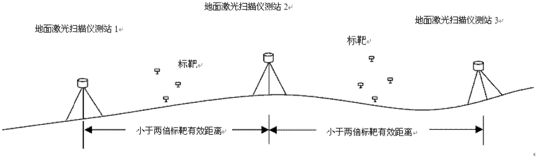
[0025] According to the task requirements, the complex overhead pipelines on the ground are scanned based on the ground 3D laser scanner. Its implementation of the standards and norms are:

...


PUM


Abstract

The invention discloses an industrial overhead pipeline measurement method based on a ground LIDAR (Light Detection And Ranging). The industrial overhead pipeline measurement method comprises the following steps of: collecting three-dimensional point cloud data of an industrial overhead pipeline; carrying out index management on the mass point cloud data according to a space position; performing model extraction of the industrial overhead pipeline and combining model data; extracting the center line and characteristic point of the industrial overhead pipeline; editing professional attribution information (such as a pipe diameter, a pipe wall thickness, a thermal insulation material, a valve type, a carrier property and the like) by using GIS (Geographic Information System) software; and realizing three-dimensional visualization. According to the invention, based on high-precision three-dimensional point cloud data, the industrial overhead pipeline data collection and management applied to GIS is finally realized by fitting the dispersed point cloud data to obtain the real mathematical model of the industrial overhead pipeline and combining the GIS software with the three-dimensional design and display software.

Description

technical field [0001] The invention relates to an industrial overhead pipeline measurement and three-dimensional GIS display method based on a ground three-dimensional laser scanner ("LIDAR" for short), which is suitable for the measurement of complex industrial overhead pipelines on the ground and the display of virtual reality, and belongs to the technical field of pipeline measurement. Background technique [0002] The current 3D data acquisition technologies for overhead industrial pipelines mainly include: (1) discrete single point acquisition of 3D coordinates, such as total stations, high-precision GPS, etc.; (2) acquisition of image data based on the principle of 2D optical photography, and then using software to The data is inferred to obtain the three-dimensional model of the entity, such as remote sensing, close-range photogrammetry, aerial photogrammetry, etc. [0003] The current display methods of industrial overhead pipelines mainly include: (1) using the pla...

Claims


Application Information

Patent Timeline
Patent Type & Authority Applications(China)
IPC IPC(8): G06F17/30G06F17/50
Inventor 王鸣霄郭江宁沈雨俞明华安中戴相喜胡泽周
Owner 南京市测绘勘察研究院股份有限公司
Why Eureka
Try Eureka