

Method for determining drainage basin surface source pollution load of semi-humid region
A non-point source pollution and determination method technology, applied in special data processing applications, instruments, electrical digital data processing, etc., to achieve the effect of improving popularity and effectiveness
- Summary
- Abstract
- Description
- Claims
- Application Information
AI Technical Summary
Problems solved by technology
Method used
Image

Examples
Embodiment
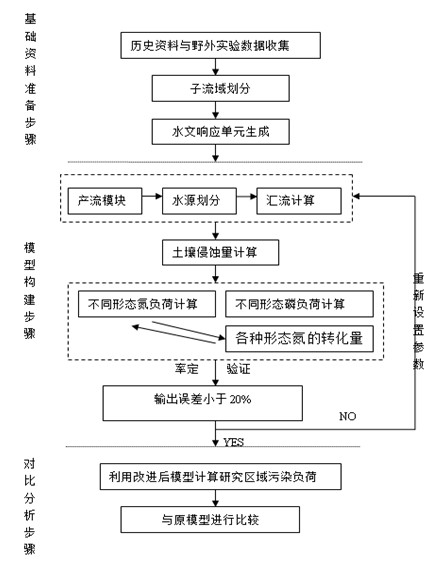
[0091] The Jialu River sub-basin in the Shaying River Basin is selected as the application area, and the area of the basin is 5900km 2 , the controlling hydrological station is Fugou Gate Station, and there are 8 rainfall stations distributed in the watershed. combined with figure 1 , specifically explaining the implementation of this example, including preliminary data preparation, calibration and verification of the improved model, and comparison with the results of the original model.
[0092] Among them, such as figure 1 As shown in the basic data preparation steps in , the data preparation for establishing the numerical simulation model of watershed non-point source pollution load includes:
[0093] a. Map of land use types
[0094] In order to meet the requirements of the model, the land use is recoded and divided into 8 categories: cultivated land, forest land, garden land, grassland, water area, rural residential area, urban land and bare land. The land use map is...
PUM
 Abstract
Description
Claims
Application Information