Remote sensing image resolution improving and processing method based on image segmentation and gravity model

A technology of image segmentation and gravity model, which is applied in image data processing, image enhancement, instruments, etc., can solve the problems of large initialization influence, ignoring spatial correlation, and large method time overhead

Inactive Publication Date: 2012-11-21
张学
View PDF0 Cites 19 Cited by
  • Summary
  • Abstract
  • Description
  • Claims
  • Application Information

AI Technical Summary

Problems solved by technology

[0016] (d) In terms of sub-pixel mapping, most of the existing sub-pixel mapping methods can only perform sub-pixel mapping for two endmembers, and the sub-pixel mapping for multiple endmembers is unstable; The pixel mapping method is greatly affected by initialization; the existing sub-pixel mapping technology only performs one sub-pixel adjustment in one iteration, and it takes too much time to adjust the position of the sub-pixel, and the time cost of the method is large; the existing sub-pixel mapping methods only Consider the spatial correlation between the sub-pixels and pixels directly adjacent to the sub-pixel, and ignore the spatial correlation between the sub-pixels and pixels in the larger neighborhood. In fact, the spatial correlation of the target is an important factor in determining the position of the sub-pixel factor

Method used


Image

  • Remote sensing image resolution improving and processing method based on image segmentation and gravity model
  • Remote sensing image resolution improving and processing method based on image segmentation and gravity model
  • Remote sensing image resolution improving and processing method based on image segmentation and gravity model

Examples


Embodiment

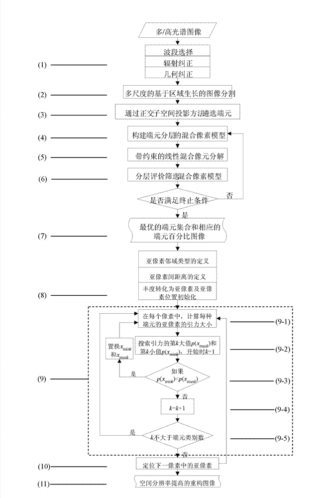
[0080] Such as Figure 1 ~ Figure 4 Shown, the concrete implementation process of this invention comprises the following steps:

[0081] (1) Perform preprocessing such as band selection, radiation correction and geometric correction on the image;

[0082] (2) Carry out multi-scale image segmentation based on region growing to the image;

[0083] (3) In each segmentation block, use the orthogonal subspace projection method to obtain endmembers, and select a plurality of endmembers to be selected;

[0084] (4) Use the to-be-selected endmembers to perform stratification to construct a mixed pixel model of the endmember hierarchy, and different endmember combinations correspond to different mixed pixel models;

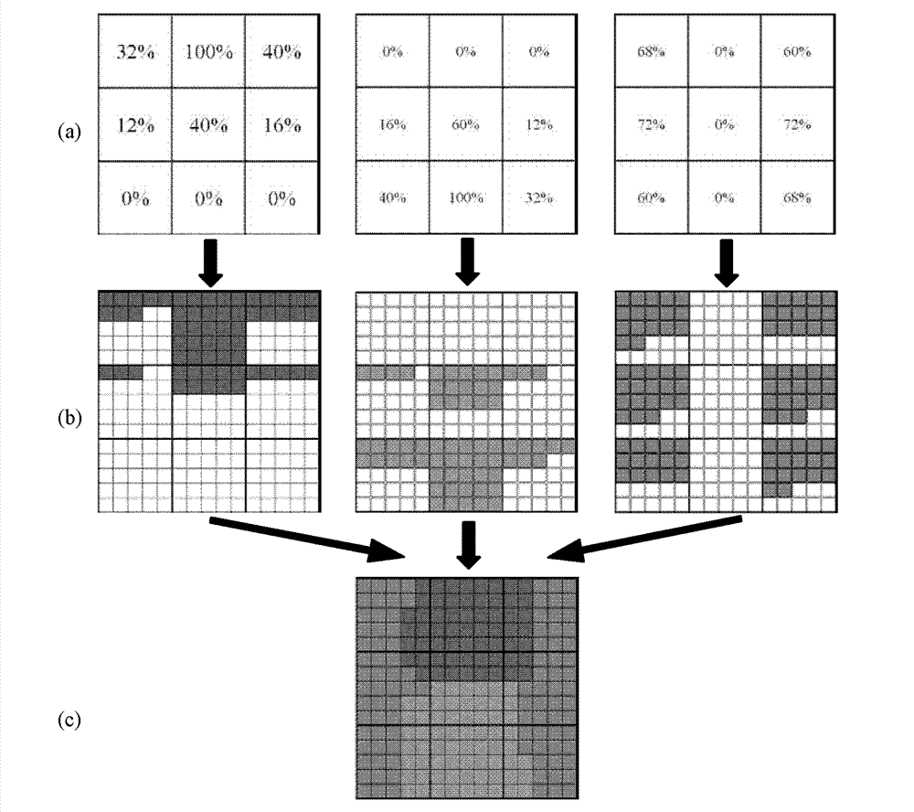
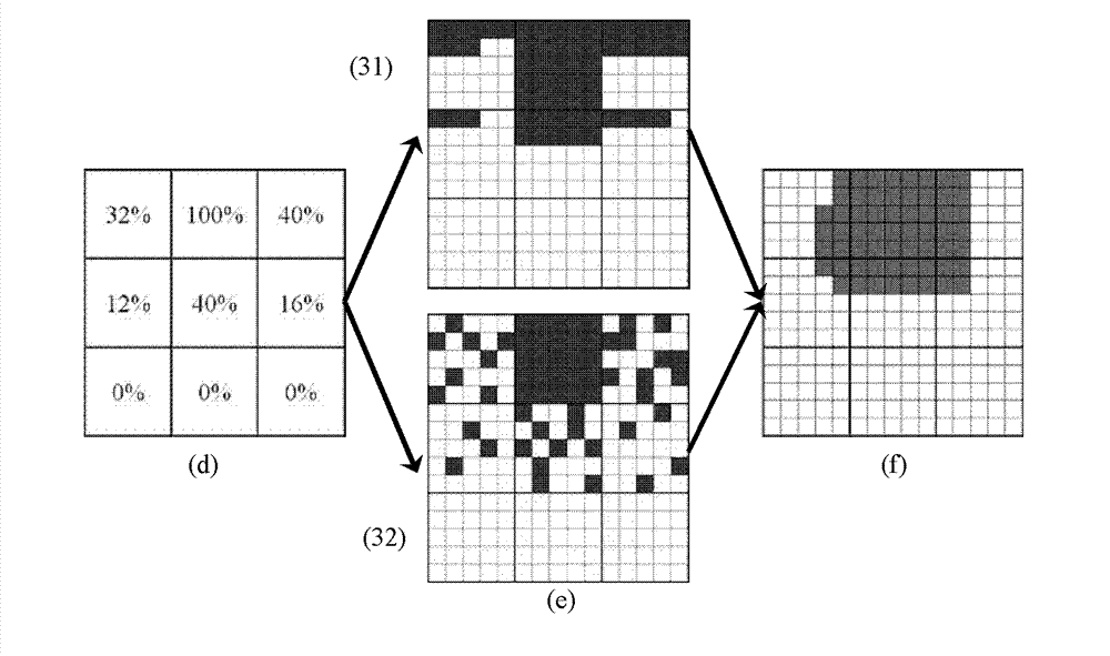
[0085] (5) Use the least squares mixed pixel decomposition method with constraints to calculate and compare all endmember combinations, the endmember combination with the smallest decomposition error is the selected best endmember set, and obtain the endmember combinatio...


PUM


Abstract

The invention relates to a remote sensing image resolution improving and processing method based on image segmentation and a gravity model. The method comprises the steps of preprocessing an image; performing multi-scale image segmentation of the image; selecting end members to be selected by using a orthogonal subspace projection method; constructing mixed pixel models with layered end members; obtaining the percentage values of the end members in various mixed pixels by using a mixed pixel decomposition method; selecting the mixed pixel models layer by layer; obtaining an optimum mixed pixel decomposition image; converting mixed pixel decomposition images of the end members into sub-pixel images; adjusting positions of sub-pixels and ensuring the total gravitational force among all the sub-pixels to be maximum; adjusting sub-pixels in all pixels repeatedly until all pixels in the images are processed and the processing is finished; and after the processing, obtaining sub-pixel images of which the spatial resolution is improved. Compared with the prior art, the method has the advantages of being simple in method, independent from high spatial resolution, good in anti-noise performance and capable of saving plenty of time.

Description

technical field [0001] The invention relates to a processing method for improving the resolution of remote sensing images, in particular to a processing method for improving the resolution of remote sensing images based on image segmentation and a gravity model. Background technique [0002] For the optical remote sensor system, the spatial resolution and spectral resolution of the image are a pair of contradictions. Under the condition of a given signal-to-noise ratio, a higher spectral resolution (narrow spectral band) often means to reduce the spatial resolution. Therefore, the accuracy and recognition degree of image target recognition are greatly limited. On the premise of preserving the spectral information, it is of great significance to improve the spatial resolution. Improving hardware technology is the most direct way to improve image spatial resolution, but under the limitation of existing hardware conditions, algorithm and software technology become the main way...

Claims


Application Information

Patent Timeline
Patent Type & Authority Applications(China)
IPC IPC(8): G06T5/00
Inventor 张学
Owner 张学
Why Eureka
Try Eureka