Shallow underwater topography construction method integrating hyper-spectral data and sparse sonar data

An underwater terrain and construction method technology, applied in image data processing, instruments, calculations, etc., can solve the problems of difficult acquisition of optical parameter observations, low model inversion accuracy, complex optical characteristics, etc., to achieve low-cost construction, Realistic and cheap interpolation results

Inactive Publication Date: 2013-01-02
NANJING UNIV
View PDF2 Cites 10 Cited by
  • Summary
  • Abstract
  • Description
  • Claims
  • Application Information

AI Technical Summary

Problems solved by technology

[0007] Whether it is a theoretical model based on the radiative transfer equation of visible light in water or a semi-empirical model based on the principle of radiative attenuation of light in water, due to the complex optical properties of water, it is difficult to obtain optical parameter observations, which affects the accuracy of water depth i

Method used


Image

  • Shallow underwater topography construction method integrating hyper-spectral data and sparse sonar data
  • Shallow underwater topography construction method integrating hyper-spectral data and sparse sonar data
  • Shallow underwater topography construction method integrating hyper-spectral data and sparse sonar data

Examples


Embodiment Construction

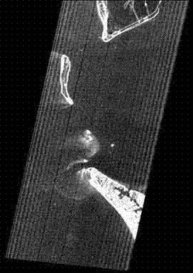
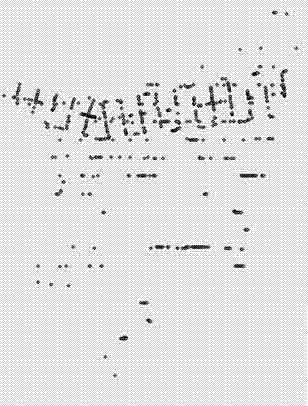
[0035] This example constructs the underwater terrain of Tampa Bay, a bay near the Gulf of Mexico on the east coast of the United States. The hyperspectral remote sensing data used is a scene in 2004. The data has a total of 242 bands and a spatial resolution of 30 meters. figure 1 As shown; the sonar data used is the single-point sonar data of Tampa Bay in 2004, the distance between adjacent routes in the data is 500m, and the distance between sonar points on the route is 3.5m, as shown in figure 2 shown.

[0036] In this example, the shallow water underwater terrain construction method integrating hyperspectral data and sparse sonar data mainly includes the following steps:

[0037] Step 1. Data preparation.

[0038] 1) Preprocessing the hyperspectral data. The data used in this embodiment has undergone processes such as speckle removal, echo correction, background removal, radiation correction, bad pixel recovery, and image quality inspection. However, in practical appl...


PUM


Abstract

The invention relates to a shallow underwater topography construction method integrating hyper-spectral data and sparse sonar data and belongs to the technical field of underwater topography reconnaissance. According to the shallow underwater topography construction method, dimensions of a hyper-spectral remote sensing image are reduced by aid of a clustering center of sonar data, area division is performed on a low dimensional remote sensing image after dimension reducing, and interpolation is performed on sonar data inside each of the areas to obtain the underwater topography. According to the shallow underwater topography construction method, the hyper-spectral remote sensing image and sparse sonar data are organically combined, in the whole process, and two kinds of data compensate to solve the problem of underwater topography construction well. The remote sensing image and the sonar data are provided with coordinate information after geometric correction, and a certain fuzzy corresponding relation exists between a grayscale of the remote sensing image and the water depth, so that water depth in each depth homogeneous area changes slightly in area-divided remote sensing image, and interpolation results of sonar data are authentic.

Description

technical field [0001] The invention relates to a shallow-water underwater terrain construction method, in particular to an underwater terrain construction method integrating hyperspectral data and sparse sonar data, and belongs to the technical field of underwater terrain surveying. Background technique [0002] Coastal and offshore continental shelf areas are areas where land and sea frequently interact, with superior geographical location, rich resources, and intense human activities. From the perspective of resource development and utilization, the offshore continental shelf is a strategic development base for oil and gas resources, food resources, and shipping resources. For this purpose, coastal protection, harbor construction, tidal flat breeding, energy development, waterway development, cable laying and other engineering facilities are carried out. There is a great need for various accurate and different scale seabed topographic maps. [0003] At present, the acqui...

Claims


Application Information

Patent Timeline
IPC IPC(8): G06T5/00
Inventor 程亮李满春刘永学蔡文婷童礼华马磊王亚飞潘航张雯陈焱明
Owner NANJING UNIV
Why Eureka
Try Eureka