Satellite gravity gradient inversion method based on power spectrum half analysis

A technology of gravity gradient and power spectrum analysis, which is used in the demonstration research of GOCE Follow-On requirements, and accurately establishes the semi-analytical error model of satellite gravity gradient inversion based on the principle of power spectrum, which can solve the sharp increase in the number of observation equations and the process of solving It is easy to analyze the requirements, simplify the calculation process, and have a clear physical meaning.

Inactive Publication Date: 2013-03-27
INST OF GEODESY & GEOPHYSICS CHINESE ACADEMY OF SCI
View PDF2 Cites 15 Cited by
  • Summary
  • Abstract
  • Description
  • Claims
  • Application Information

AI Technical Summary

Problems solved by technology

Advantages: the number of grid points is fixed, so the dimension of the equation is fixed, and the FFT method can be used for fast batch processing, so the amount of calculation is greatly reduced; Disadvantages: different degrees of approximate calculations are made in the grid processing, and Can't handle colored noise
Advantages: Directly process satellite observation data without any approximation, high solution accuracy and can effectively deal with color noise; Disadvantage: With the increase of satellite observation data, the number of observation equations increases dramatically, which great

Method used


Image

  • Satellite gravity gradient inversion method based on power spectrum half analysis
  • Satellite gravity gradient inversion method based on power spectrum half analysis
  • Satellite gravity gradient inversion method based on power spectrum half analysis

Examples


Embodiment Construction

[0031] In order to make it easier for those skilled in the art to understand and implement the present invention, the present invention will be further described in detail below in conjunction with the accompanying drawings and specific embodiments.

[0032] The satellite gravity gradient inversion method based on power spectrum semi-analysis includes the following steps:

[0033] Step 1: Gravity Gradient Satellite Data Acquisition

[0034] (1) The satellite gravity gradient measurement data δV is collected through the gravity gradient satellite's on-board gravity gradiometer xyz ;

[0035] (2) The spaceborne GPS / GLONASS composite receiver based on the gravity gradient satellite collects the satellite orbit position measurement data δr.

[0036] Step 2: Establish the signal power spectrum analysis model of the satellite gravity gradient tensor

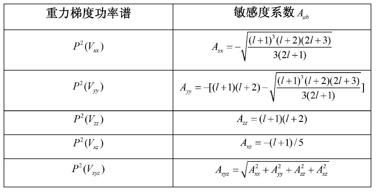
[0037] In the spherical coordinate system, the expression of the earth's gravitational potential expanded according to the spheric...


PUM


Abstract

The invention relates to a satellite gravity gradient inversion method based on power spectrum half analysis; builds an individual and a united analytical error models of accumulated geoid accuracy influenced by a gravity gradient tensor error of a satellite gravity gradient meter and an orbital position error of a global position system (GPS)/ global navigation satellite system (GLONASS) composite receiver; and simultaneously provides a method for verifying a satellite gravity gradient inversion half analysis error model, and a method for determining parameter requirements of a next generation GOCE Follow-On gravity gradient satellite according to effects of satellite gravity gradient measurement accuracy, satellite orbit position measurement accuracy and satellite orbit height on accumulated geoid based on the satellite gravity gradient inversion half analysis error model. The satellite gravity gradient inversion method is high in accuracy, high in speed of resolving the earth gravitational field, and explicit in physical meaning of a satellite observation equation, simplifies a computational process, and facilitates performing requirement analysis of a next generation gravity gradient satellite system.

Description

technical field [0001] The present invention relates to interdisciplinary technical fields such as satellite gravity gradients, geodesy, space science, and astronautics, and in particular to a method for accurately establishing a semi-analytical error model for satellite gravity gradient inversion based on the power spectrum principle and carrying out GOCE Follow-On demand demonstration research methods. Background technique [0002] The realization of satellite gravity gradient measurement (SGG) technology is another innovation and breakthrough in the field of geodesy after the successful construction of the US Global Positioning System (GPS) constellation. One of the most efficient, economical and promising methods. The GOCE gravity gradient satellite independently developed by the European Space Agency (ESA) was successfully launched on March 17, 2009. GOCE adopts near-circular, polar and sun-synchronous low orbits, with an orbital inclination of 96.5°, an orbital eccen...

Claims


Application Information

Patent Timeline
IPC IPC(8): G01V7/00
Inventor 不公告发明人
Owner INST OF GEODESY & GEOPHYSICS CHINESE ACADEMY OF SCI
Why Eureka
Try Eureka