Rail subgrade settlement measuring method based on combination of camera shooting, satellite and inertia measurement

An inertial measurement and satellite technology, which is used in railway car body parts, railway auxiliary equipment, railway vehicle shape measuring instruments, etc. 40 kilometers, the ground control signs are set too densely, etc., to achieve the effect of solving the accuracy drift with time, easy implementation and continuous measurement

Active Publication Date: 2013-12-04
NAT UNIV OF DEFENSE TECH
View PDF6 Cites 27 Cited by
  • Summary
  • Abstract
  • Description
  • Claims
  • Application Information

AI Technical Summary

Problems solved by technology

At present, inertial measurement equipment is commonly used on rail inspection vehicles and comprehensive inspection vehicles in most countries in the world. However, due to the inherent defect of inertial measurement that errors accumulate over time, the current inertial measurement on rail inspection vehicles can only measure small local areas of the subgrade. short-wave changes in the range, but cannot sensitively detect slowly changing long-wave irregularities and subsidence, and cannot achieve long-distance, long-term, high-precision subgrade settlement measurement
Chinese patent document CN101913368B discloses a system and method for rapid and precise measurement and total element dat

Method used


Image

  • Rail subgrade settlement measuring method based on combination of camera shooting, satellite and inertia measurement
  • Rail subgrade settlement measuring method based on combination of camera shooting, satellite and inertia measurement

Examples


Embodiment Construction

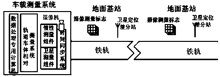
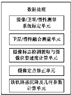
[0020] The present invention provides a roadbed settlement measurement method based on camera / satellite / inertial measurement combination, and its system scheme is as follows figure 1 As shown, it includes ground base station and vehicle measurement system.

[0021] The ground base station refers to the satellite positioning differential base station and the camera measurement mark base station set up at specific positions near the track on the ground, and the base stations are repeatedly arranged at intervals of 5 to 10 kilometers. The satellite positioning differential base station and the camera measurement mark base station can be arranged together or independently. The satellite positioning differential base station ensures that the signals of the satellite positioning differential base station cover the measurement area. The cooperation mark at the base station of the photogrammetry mark adopts the original natural mark or artificial feature marks, such as crosshairs, ci...


PUM


Abstract

The invention relates to a rail subgrade settlement measuring method based on combination of camera shooting, a satellite and inertia measurement. A vehicle platform is provided with a camera, a satellite positioning assembly, an inertia measurement assembly, a time synchronous system, a rail vehicle relative measurement system, a data processing special-purpose computer and the like. Satellite positioning differential base stations and camera shooting survey mark base stations are distributed along a rail to constitute a combination measurement system of camera shooting, the satellite and inertia measurement or a combination measurement system of camera shooting and inertia measurement or a combination measurement system of the satellite and inertia measurement, high-precision vehicle-mounted dynamic position, altitude and speed measurement references are built through deep integration of camera shooting, the satellite and inertia measurement, high-precision measurement of rail and subgrade measurement parameters is maintained for a long time according to the rail vehicle relative measurement system, and by comparison with rail design standard data, automatic, high-precision, long-time and continuous measurement of rail subgrade settlement and rail geometric parameters is achieved.

Description

technical field [0001] The invention relates to the field of rail traffic dynamic detection, in particular to a method for vehicle-mounted railroad subgrade settlement measurement. By installing camera / satellite / inertial measurement components on the vehicle-mounted platform, satellite positioning differential stations and camera control signs are arranged along the railroad track, and real-time dynamic Measure the position, attitude, and speed information of the vehicle-mounted platform, and use the relative measurement of the rail car body to obtain the three-dimensional position and geometric parameters of the rail space. By comparing with the standard data of the track design, the automatic, high-precision, and long-term measurement of the settlement of the rail subgrade and the geometric parameters of the rail is realized. , Continuous measurement. Background technique [0002] The vigorous construction and use of rail transit infrastructure has played an extremely impo...

Claims


Application Information

Patent Timeline
IPC IPC(8): B61K9/08
Inventor 于起峰张红良姜广文尚洋张小虎
Owner NAT UNIV OF DEFENSE TECH
Why Eureka
Try Eureka