Method of filtering airborne LiDAR (Light Detection and Ranging) point cloud

A point cloud and point cloud data technology, applied in image data processing, instrumentation, computing, etc., can solve problems such as the destruction of complex terrain structure features, avoid blindness and the tediousness of frequent adjustment of filtering parameters, and avoid point cloud accuracy. loss, the effect of high filtering accuracy

Inactive Publication Date: 2014-04-23
HOHAI UNIV
View PDF2 Cites 23 Cited by
  • Summary
  • Abstract
  • Description
  • Claims
  • Application Information

AI Technical Summary

Problems solved by technology

In 2004, ISPRS organized scholars to conduct comparative research on various filtering algorithms: almost every filtering algorithm has its applicable terrain field or corresponding point cloud distribution with good filtering effect, but at the same time, almost every algorithm also has its own However, there is no algorithm that can take into account all aspects of data filtering and set relevant parameters for various factors
However, due to the lack of reasonable guidance of terrain feature information, the filtering parameters need to be adjusted frequently for different terrain conditions in the filtering process, and the complex terrain structure features will be damaged to a certain extent.

Method used


Image

  • Method of filtering airborne LiDAR (Light Detection and Ranging) point cloud
  • Method of filtering airborne LiDAR (Light Detection and Ranging) point cloud
  • Method of filtering airborne LiDAR (Light Detection and Ranging) point cloud

Examples


Embodiment Construction

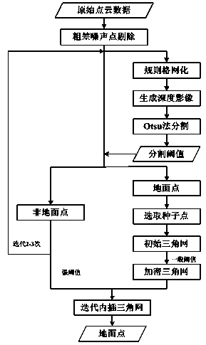
[0037] Below in conjunction with accompanying drawing, technical scheme of the present invention is described in further detail:

[0038] like figure 1 As shown, an airborne LiDAR point cloud filtering method includes the following steps:

[0039] 1. Preprocess the original point cloud data and remove gross noise points;

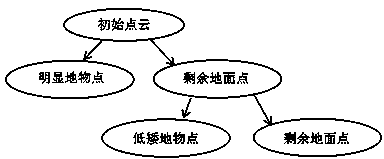
[0040] The CSite2 reference data published online by ISPRS is selected as the experimental data, and the area of ​​the experimental area is 630×420m 2 , the number of points is 243,400. There are complex houses, large buildings and data holes in the area, and the average point distance is 1-1.5m. The point cloud data in the experimental area are classified manually or semi-manually, and each point is marked as a ground point or a non-ground point. Take any point P i is the target point, r is the radius of the search circle, searching for adjacent points, if for any point P j :

[0041] Z j -Z i ≥ΔZ max ,P j ∈A

[0042] where A is the search area, ...


PUM


Abstract

The invention discloses a method of filtering an airborne LiDAR (Light Detection and Ranging) point cloud. The method comprises the following steps of firstly, carrying out gross error elimination and regular grid transformation on LiDAR point cloud data so as to generate a depth image; secondly, computing a segmented elevation threshold through an Otsu algorithm in an image threshold segmentation technology, and carrying out iterative rough classification of ground points and non-ground points on the point cloud data, which are obtained before regular grid transformation and resampling, through the threshold; lastly, respectively carrying out progressive triangulation network filtering on the classified ground points and non-ground points through the two different thresholds, and outputting network construction point cloud data, namely, ground point data. According to the method, the point cloud data, which participate in a filtering process, are data, which are obtained before regular grid transformation and resampling, so that the problem of accuracy loss of the point cloud due to regular grid transformation can be effectively avoided; a categorical attribute guidance is provided for the progressive triangulation network filtering, a filtering strategy is correspondingly adjusted for different terrain conditions, so that a better filtering effect is obtained.

Description

technical field [0001] The invention relates to an airborne LiDAR point cloud filtering method, in particular to an airborne LiDAR point cloud filtering method based on the iterative Otsu method for point cloud rough classification. Background technique [0002] Airborne LiDAR (LiDAR, Light Detection And Ranging, LiDAR) is a new measurement technology gradually developed in recent years, which is mainly used to quickly and accurately obtain three-dimensional spatial information of ground and ground targets. The airborne LiDAR system integrates laser scanning, Global Positioning System (GNSS, Global Navigation Satellite System), and Inertial Navigation System (INS, Inertial Navigation System). It acquires target information by emitting laser pulses and receiving echo signals. Compared with other measurement It is less affected by weather factors and can carry out all-day remote sensing operations. Together with imaging spectroscopy and Synthetic Aperture Radar (SAR, Syntheti...

Claims


Application Information

Patent Timeline
Patent Type & Authority Applications(China)
IPC IPC(8): G06T5/00
Inventor 李成仁岳东杰于双袁豹
Owner HOHAI UNIV
Why Eureka
Try Eureka