Power line extracting and modeling method based on airborne LiDAR data

A modeling method and power line technology, applied in the direction of electromagnetic wave re-radiation, radio wave measurement system, utilization of re-radiation, etc., can solve the problems of inaccurate power line identification and high data quality requirements, and achieve good extraction effect and low data quality requirements. , the effect of simple steps

Inactive Publication Date: 2014-09-03
AERIAL PHOTOGRAMMETRY & REMOTE SENSING CO LTD
View PDF7 Cites 38 Cited by
  • Summary
  • Abstract
  • Description
  • Claims
  • Application Information

AI Technical Summary

Problems solved by technology

[0005] The technical problem to be solved by the present invention is to provide a power line extraction and modeling method based on airborne LiDAR data in view of the deficiencies in the above-mentioned prior art. , ...

Method used


Image

  • Power line extracting and modeling method based on airborne LiDAR data
  • Power line extracting and modeling method based on airborne LiDAR data
  • Power line extracting and modeling method based on airborne LiDAR data

Examples


Embodiment Construction

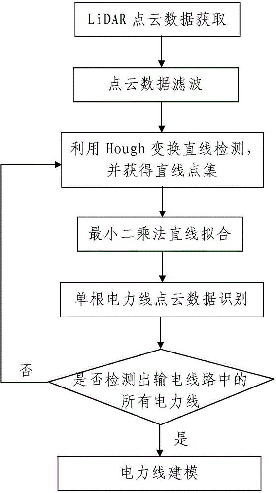
[0051] Such as figure 1 A power line extraction and modeling method based on airborne LiDAR data is shown, including the following steps:

[0052] Step 1, LiDAR point cloud data acquisition: use the airborne LiDAR measurement system to acquire the point cloud data of the transmission line, and transmit the acquired point cloud data to the data processing device, the point cloud data includes the adjacent points in the transmission line The three-dimensional coordinates of multiple measuring points between two electric towers, and the two-dimensional coordinates of multiple measuring points between two adjacent electric towers in the transmission line on the X-Y plane form a two-dimensional data set; where, the X-Y plane is The horizontal plane where the Cartesian coordinate system of the X-Y axis plane is located.

[0053] The power transmission line includes M power lines erected between two adjacent electric towers, wherein M is a positive integer and M≥2.

[0054] In this...


PUM


Abstract

The invention discloses a power line extracting and modeling method based on airborne LiDAR data. The power line extracting and modeling method includes the steps of (1) LiDAR point cloud data obtaining, wherein the LiDAR point cloud data are obtained through an airborne LiDAR measuring system; (2) power line extracting and modeling, wherein the step (201) of power line extracting includes the substeps that Hough transformation straight line detection is used for detection to obtain a plurality of straight line point sets, single-power-line detection is carried out on all the straight line point sets until all power lines are detected out, and the single-power-line detection process includes least square method straight line fitting and single-power-line point cloud data recognition; the step (202) of power line modeling includes the substeps that with a parabola as a modeling model, the least square method is adopted for curve fitting to obtain a power line model. The power line extracting and modeling method is simple in step, convenient to implement and good in using effect, the extraction precision of the power lines is high, the built power line model is accurate, and the problems that according to an existing power line extracting and modeling method, power line recognition is inaccurate, and requirements for data quality are high can be effectively solved.

Description

technical field [0001] The invention relates to a power line extraction and modeling method, in particular to a power line extraction and modeling method based on airborne LiDAR data. Background technique [0002] Airborne laser radar (LiDAR) is a new type of measurement technology developed around the 1990s. This technology uses active detection methods to quickly obtain high-precision, high-density three-dimensional coordinate information of the earth's surface and ground objects. Based on the high-precision three-dimensional spatial coordinate information contained in the point cloud data, it can accurately express the surface spatial characteristics of the scanned object, which is also of great significance in geospatial information research, urban planning, and land management. [0003] With the continuous maturity of LiDAR technology, its application in power line inspection has gradually become a hot spot in the industry. LiDAR can well solve the problems of spatial ...

Claims


Application Information

Patent Timeline
IPC IPC(8): G01S17/89G01S7/48
CPCG01S7/48G01S17/89
Inventor 刘敏宋袁龙包瑞飞王慧芳
Owner AERIAL PHOTOGRAMMETRY & REMOTE SENSING CO LTD
Why Eureka
Try Eureka