
Satellite navigation method for interactive multi-model UKF with self-adapting factors

An interactive multi-model and adaptive factor technology, applied in the field of navigation control, can solve the problem of low filtering accuracy and achieve the effect of improving positioning accuracy

Active Publication Date: 2014-09-03
BEIJING INSTITUTE OF TECHNOLOGYGY
View PDF4 Cites 19 Cited by
  • Summary
  • Abstract
  • Description
  • Claims
  • Application Information

AI Technical Summary

Problems solved by technology

[0005] The present invention proposes an interactive multi-model UKF satellite navigation method with self-adaptive factors for the problem of low filtering accuracy due to the unknown complex maneuvering carrier motion model and noise statistical characteristics in the satellite navigation system, which effectively improves the accuracy of the satellite navigation system in the satellite navigation system. Positioning Accuracy of Complex Maneuvering Carriers with Unknown Model and Statistical Properties of Noise

Method used


Image

  • Satellite navigation method for interactive multi-model UKF with self-adapting factors
  • Satellite navigation method for interactive multi-model UKF with self-adapting factors
  • Satellite navigation method for interactive multi-model UKF with self-adapting factors

Examples


Embodiment Construction

[0094] In order to better illustrate the purpose and advantages of the present invention, the present invention will be further described below in conjunction with the accompanying drawings and implementation examples.

[0095] In this embodiment, the vehicle-mounted positioning task on the ground is to be completed within 300 seconds. The vehicle moves at a constant speed from 0 to 60 seconds, turns at a constant speed from 60 to 102 seconds, moves in a straight line at a constant speed from 103 to 162 seconds, turns at a constant speed from 183 to 195 seconds, and turns at a constant speed within 196 seconds. Do uniformly accelerated linear motion within 205 seconds, and uniformly decelerate linear motion within 206 seconds to 300 seconds.

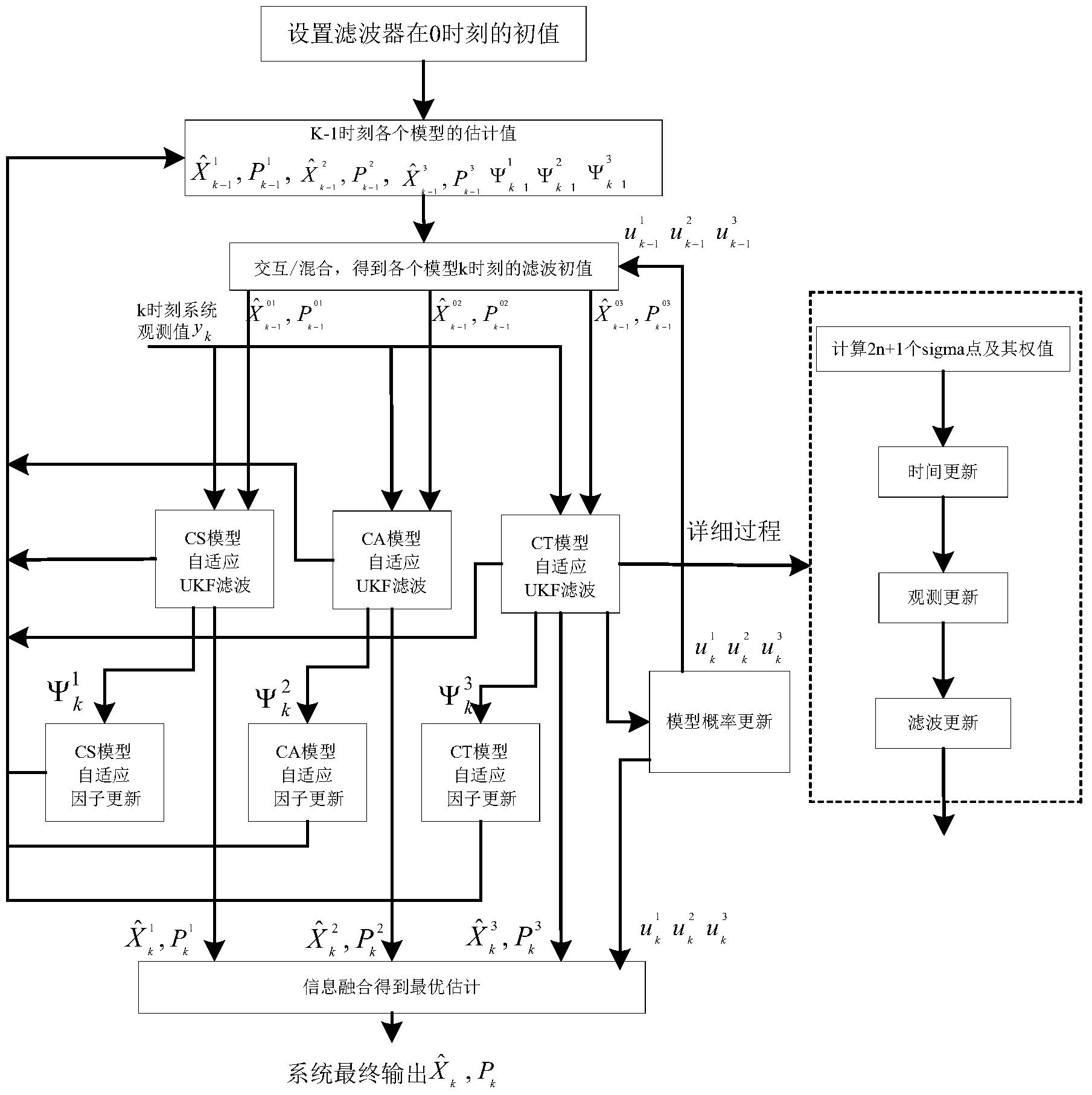
[0096] Use the self-adaptive estimation method applied to satellite navigation proposed by the present invention to perform positioning, and its flow is as follows figure 1 As shown, the specific steps are as follows:

[0097] Step 1: ...


PUM


Abstract

The invention relates to a satellite navigation method for an interactive multi-model UKF with self-adapting factors, and belongs to the field of navigation control. The method comprises the steps that firstly, an auto-covariance matrix of a residual sequence is used as a correcting value, and a smoothing filter is designed for fusing the correcting value with the old self-adapting factor to obtain the new self-adapting factor; secondly, a covariance matrix of process noise is adjusted in real time by utilizing the self-adapting factor, and therefore positioning errors, caused by unknown noise statistics properties, in a system are effectively reduced; afterwards, a model set M is set by the adoption of the interactive multi-model (IMM) algorithm; finally, soft handover between models is achieved by adjusting model probability in real time according to measurement residual errors, so that positioning errors caused by inaccurate system models are reduced. According to the method, the positioning accuracy of a complex motor carrier in a satellite navigation system is effectively improved with models and noise statistical properties unknown.

Description

technical field [0001] The invention relates to an interactive multi-model UKF satellite navigation method with adaptive factors, belonging to the field of navigation control. Background technique [0002] The receiver positioning algorithm is the key to the positioning accuracy of the satellite navigation system. For a long time, the least square method has been widely used because of its simple principle and easy implementation. However, the least squares method does not connect the estimated values ​​at different times, and the positioning results appear scattered and chaotic, which creates difficulties for the optimization of the navigation algorithm. In order to overcome the shortcomings of the least squares method in estimation performance, scholars have applied nonlinear filtering algorithms to the field of navigation. For the filtering problem of nonlinear systems, due to the need to deal with infinite-dimensional integral operations, it is difficult to find a stri...

Claims


Application Information

Patent Timeline
IPC IPC(8): G01S19/42G06F19/00
CPCG01S19/42
Inventor 董宁徐玉娇刘向东陈振刘冰
Owner BEIJING INSTITUTE OF TECHNOLOGYGY
Learn More