Remote-sensing image relative correction method and system integrating geometry and radiation

A technology for geometric correction and remote sensing images, applied in image enhancement, image data processing, material analysis using microwave means, etc., can solve problems such as not providing integrated calculation of geometry and radiation coefficient, and achieve good scientific and practical value. The effect of improving the accuracy of correction

Active Publication Date: 2014-09-17
HUAZHONG NORMAL UNIV
View PDF2 Cites 13 Cited by
  • Summary
  • Abstract
  • Description
  • Claims
  • Application Information

AI Technical Summary

Problems solved by technology

The current remote sensing image preprocessing methods do not consider the two as a whole, not only the commonly used remote sensing image processing software (such as ENVI and ERDAS) does...

Method used


Image

  • Remote-sensing image relative correction method and system integrating geometry and radiation
  • Remote-sensing image relative correction method and system integrating geometry and radiation
  • Remote-sensing image relative correction method and system integrating geometry and radiation

Examples


Embodiment Construction

[0047] The technical solution of the present invention can be realized by computer programs, and the present invention will be further described below in conjunction with the accompanying drawings and specific embodiments.

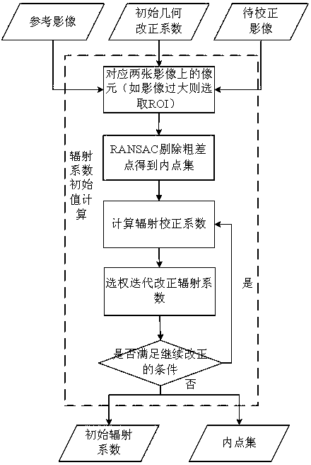
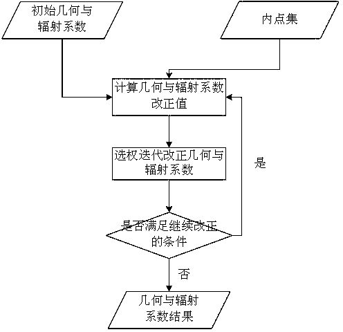
[0048] see Figure 1~3 , the remote sensing image geometry and radiation integration relative correction method of the present invention, the specific steps are:

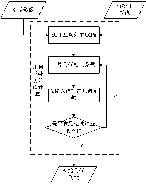
[0049] Step 1, calculate the initial value of the geometric correction coefficient.

[0050] Input the reference image and the image to be corrected, and obtain the control points of the reference image and the image to be corrected by automatic matching, eliminate the mismatched points in the control points to obtain the inner point set A, and bring the coordinates of the inner point set A into the geometric correction polynomial The model calculates the geometric correction coefficient, and the obtained geometric correction coefficient is the initial value of the geometric correction coeffici...


PUM


Abstract

The invention discloses a remote-sensing image relative correction method and system integrating geometry and radiation. The method includes the steps of generating a control point on an image by means of combination of automatic matching and gross error detection, calculating an initial value of a geometry correction coefficient, detecting radiation invariant of the image to be corrected, calculating the initial value of a radiation correction coefficient, putting a geometric correction model into a linear radiation correction equation, building an error equation integrating geometry and radiation coefficients, calculating a correction coefficient by means of a weighing total least square method, solving the error equation to obtain a correction coefficient modification value and iterating and optimizing the correction coefficient modification value. According to the method, the geometry coefficient and the radiation coefficient in image correction can be calculated simultaneously, and the method lives up to the objective law, is scientific and can further improve correction precision.

Description

technical field [0001] The invention belongs to the technical field of remote sensing image preprocessing, and relates to a remote sensing image geometry and radiation integrated relative correction method and system. Background technique [0002] Remote sensing is a technology that detects and recognizes targets by non-contact sensing electromagnetic waves reflected by targets or radiated by themselves. At present, remote sensing technology has been widely used in many fields such as agriculture, forestry, geology, geography, oceanography, hydrology, meteorology, surveying and mapping, environmental protection and military reconnaissance. For the original remote sensing image obtained by the sensor, due to the existence of geometric distortion and radiation distortion, preprocessing is essential. Remote sensing image preprocessing methods include geometric correction and radiometric correction: [0003] (1) Geometric correction [0004] Geometric correction uses a series...

Claims


Application Information

Patent Timeline
IPC IPC(8): G06T5/00G01N22/00
Inventor 李畅熊昊
Owner HUAZHONG NORMAL UNIV
Why Eureka
Try Eureka