
Novel-radar-and-sensor-technology-based mine management method

A technology of sensor technology and management method, which is applied in the field of mine management based on new radar and sensor technology, can solve the problems of large amount of equipment and complicated methods, and achieve the effect of long action distance, large observation area and not easy to be damaged

Inactive Publication Date: 2014-12-03
黄云
View PDF0 Cites 2 Cited by
  • Summary
  • Abstract
  • Description
  • Claims
  • Application Information

AI Technical Summary

Problems solved by technology

However, this method requires a large amount of equipment and is complicated

Method used


Image

  • Novel-radar-and-sensor-technology-based mine management method
  • Novel-radar-and-sensor-technology-based mine management method
  • Novel-radar-and-sensor-technology-based mine management method

Examples


Embodiment 1

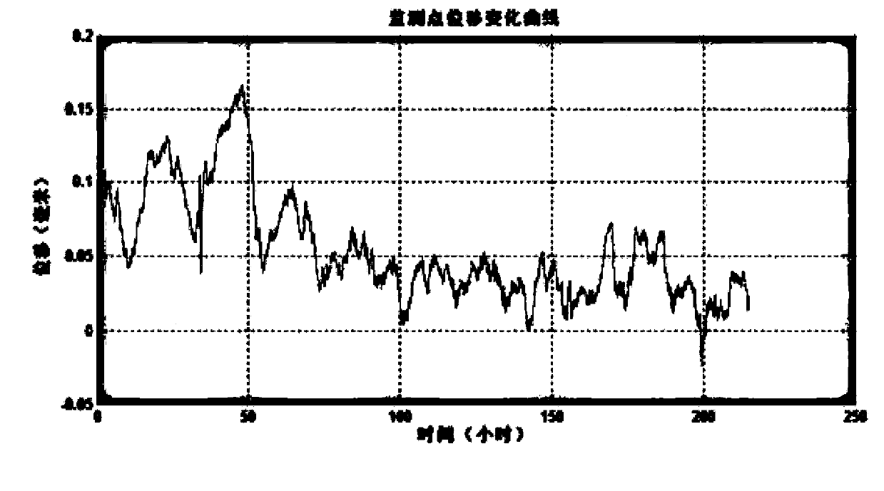
[0038] Firstly, the radar is used to monitor the length of the dry beach of the tailings pond. The radar is placed in a fixed position, and the radar scans the monitoring area to form a two-dimensional image. From the two-dimensional image, the waterline and the outline of the dry beach can be distinguished. Radar images are different from optical images. Radar images contain accurate distance information. The actual radar monitoring area is the fan-shaped area on the front of the radar. In the next step, after continuously obtaining two-dimensional images of the monitoring area based on radar imaging technology, use the radar image The phase information of the tailings reservoir can be solved to calculate the displacement of the dam body. The monitoring accuracy of tailings dam deformation using this technology depends on the signal-to-noise ratio of the image. A strong scattering corner reflector can be installed at the position to be monitored to strengthen the scattering ef...

Embodiment 2

[0040] Firstly, the radar is used to monitor the length of the dry beach of the tailings pond. The radar is placed in a fixed position, and the radar scans the monitoring area to form a two-dimensional image. From the two-dimensional image, the waterline and the outline of the dry beach can be distinguished. Radar images are different from optical images. Radar images contain accurate distance information. The actual radar monitoring area is the fan-shaped area on the front of the radar. Preferably, in order to obtain a larger observation area, the radar can be deployed at a certain height. Look down and scan the tailings pond area to be monitored. The precise dry beach length can be calculated by using the distance information from the waterline to the top of the dry beach and the irradiation angle of the radar, and the dry beach lengths of all sections of the dry beach in the monitoring area can be obtained, and the smallest one is the minimum dry beach Length, for tailings ...

Embodiment 3

[0042] Use radar to monitor the length of the dry beach of the tailings pond. The radar is placed in a fixed position, and the radar scans the monitoring area to form a two-dimensional image. From the two-dimensional image, the waterline and the outline of the dry beach can be distinguished. Radar images are different from optical images. Radar images contain accurate distance information. The actual radar monitoring area is the fan-shaped area on the front of the radar, as shown in the red line in the figure below. Each resolution unit after radar imaging is also fan-shaped. After geometric correction, the radar image can form an effect similar to a general optical image. The radar can be deployed at a certain height, looking down and scanning the tailings pond area to be monitored. The precise dry beach length can be calculated by using the distance information from the waterline to the top of the dry beach and the irradiation angle of the radar, and the dry beach lengths of ...


PUM


Abstract

The invention discloses a novel-radar-and-sensor-technology-based mine management method. Therefore, an accurate high-resolution image of an observation area, precise distance and dimension information of the observation object in the observation area, and deformation and settlement information of the observation object can be obtained. Compared with the traditional optical remote sensing and mapping technology, the radar has the following advantages: the observation area is large, the operating range is long, and the radar mapping distance can reach several kilometers maximally; but the optical equipment with the same observation distance is expensive and the observation range of the equipment can not compare with that of the radar. The reliability of the radar is high, and no precise and sensitive element of the radar equipment is exposed and thus the elements can be protected from being damaged and no special maintenance requirement is made; however, the lens of the common optical mapping equipment needs to be maintained specially. The general optical mapping equipment requires a certain illumination intensity of the observation area; but the radar equipment can work normally day and night. And the radar equipment has the high environment adaptation capability and can work normally under common weather conditions of rain, fog, snow, smoke, and dust and the like or in common environments.

Description

technical field [0001] The invention belongs to the field of mine management, and in particular relates to a mine management method based on novel radar and sensor technology. Background technique [0002] Tailings pool refers to the place where dams are built to intercept valley mouths or enclosures, and are used to stockpile metal or non-metal mines for ore sorting and discharge tailings mud or other industrial waste residues. Tailings pond is the largest environmental protection engineering project for mining enterprises. It can prevent tailings from being discharged randomly to rivers, rivers, lakes, sea deserts and grasslands. As long as tailings are produced in a mine concentrator, a tailings pond must be built, and the tailings pond is an indispensable part of the production of a mine concentrator. The tailings pond is a dangerous source of man-made debris flow with high potential energy. During the period of more than ten years or even decades, various natural (rai...

Claims


Application Information

Patent Timeline
Patent Type & Authority Applications(China)
IPC IPC(8): G01V3/12
Inventor 黄云邓露陈宇亮吴阳香
Owner 黄云
Learn More