Method for evaluating forest fire spreading risk of power transmission channel
A forest fire spread and risk assessment technology, applied in image data processing, instruments, data processing applications, etc., can solve the problems that do not involve the relationship between flame height and forest fire intensity, which causes line tripping, and achieve the effect of improving accuracy
- Summary
- Abstract
- Description
- Claims
- Application Information
AI Technical Summary
Problems solved by technology
Method used
Image
Examples
Embodiment Construction
[0027] The present invention is further described below in conjunction with accompanying drawing:
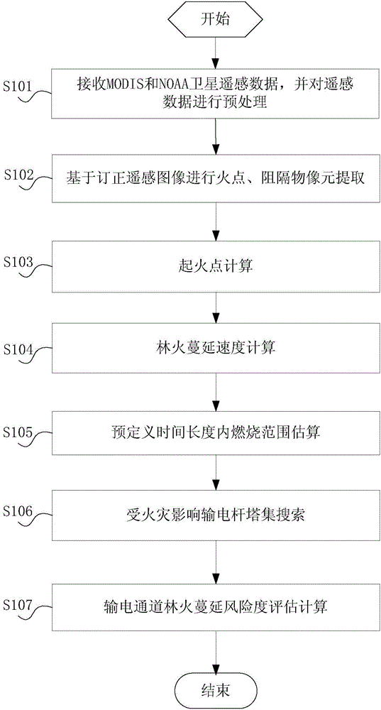
[0028] The present invention proposes a risk assessment method for forest fire spread in power transmission channels, figure 1 For the specific flow chart of this method, by figure 1 As can be seen, the method includes:
[0029] S101: Receive MODIS (Moderate Resolution Imaging Spectroradiometer) and NOAA (National Oceanic and Atmospheric Administration) satellite remote sensing data, and preprocess the remote sensing data.
[0030] In a specific embodiment of the present invention, satellite remote sensing images can be collected by MODIS (moderate resolution imaging spectrometer) satellites and NOAA (National Oceanic and Atmospheric Administration of the United States) satellites. After positioning and calculating the sun altitude angle, the 1B data set is obtained. Then correct the sun altitude angle, limb darkening correction, and map projection transformation on the 1B da...
PUM
 Abstract
Description
Claims
Application Information
 - R&D
- Intellectual Property
- Life Sciences
- Materials
- Tech Scout
- Unparalleled Data Quality
- Higher Quality Content
- 60% Fewer Hallucinations
Browse by: Latest US Patents, China's latest patents, Technical Efficacy Thesaurus, Application Domain, Technology Topic, Popular Technical Reports.
© 2025 PatSnap. All rights reserved.Legal|Privacy policy|Modern Slavery Act Transparency Statement|Sitemap|About US| Contact US: help@patsnap.com


