Method for geological navigation and geological mapping through portable intelligent device based on Andriod

A smart device and portable technology, applied in navigation, surveying and mapping and navigation, road network navigator, etc., can solve the problems of not integrating multiple sensors, no synchronous communication, and small use share, so as to improve field work efficiency and content level The effect of clarifying and eliminating theoretical errors

Active Publication Date: 2015-04-08
POWER CHINA KUNMING ENG CORP LTD
View PDF6 Cites 35 Cited by
  • Summary
  • Abstract
  • Description
  • Claims
  • Application Information

AI Technical Summary

Problems solved by technology

[0002] The traditional method of field engineering geological surveying and mapping is completed by paper media + manual collection, which makes it difficult to carry and manage background data, text records, sketch maps, catalog maps, geological photos and sampling information, narrow survey field of view, and time-consuming to find geological targets strenuous
The positioning accuracy of geological feature points, lines, surfaces, and volumes is greatly affected by terrain accuracy and experience. On-site geological surveying and mapping have almost no synchronous communication with the rear, and quality control is difficult. To a certain extent, it has been difficult to adapt to the increasingly severe market competition situation
At present, there are some field geological data acquisition systems based on notebook computers, professional GPS, 3G mobile phones and tablet computers under Windows operating syste...

Method used


Image

  • Method for geological navigation and geological mapping through portable intelligent device based on Andriod
  • Method for geological navigation and geological mapping through portable intelligent device based on Andriod
  • Method for geological navigation and geological mapping through portable intelligent device based on Andriod

Examples


Embodiment Construction

[0045] In order to make the object, technical solution and advantages of the present invention more clear, the present invention will be further described in detail below in conjunction with the examples. It should be understood that the specific embodiments described here are only used to explain the present invention, not to limit the present invention.

[0046]Those skilled in the art will understand that the following examples are only for illustrating the present invention and should not be considered as limiting the scope of the present invention. If no specific technique or condition is indicated in the examples, it shall be carried out according to the technique or condition described in the literature in this field or according to the product specification. All the instruments used are conventional products that are not indicated by the manufacturer.

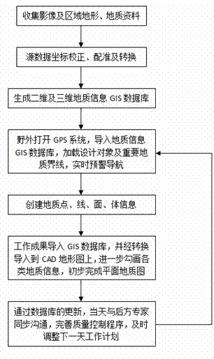
[0047] Such as figure 1 Shown, based on the Andriod operating system GIS+GPS integrated technology portable intelli...


PUM


Abstract

The invention relates to a method for geological navigation and mapping by using an Andriod flat panel or a mobile phone and belongs to the technical field of geological survey. The method is based on an Andriod operating system and consumes a less memory, the device is convenient to carry, user groups are many, and the device is low in price and easy to popularize; a GIS+GPS integration technology is utilized, and the field navigation and positioning is more accurate after coordinate processing; a two-dimensional or three-dimensional geological information GIS database that can be updated dynamically is established, geological recording information comprises audio and video information, the field operation is visual and simple, the content level is clear, no repetition or omission occurs, a previous pure recording mode of character and photo information is changed, the field working efficiency is improved, the blank of field engineering geological mapping system quality control procedures is filled through synchronous communication with rear experts, a working plan can be adjusted timely, and field geological mapping target is clearer.

Description

technical field [0001] The invention belongs to the technical field of geological survey, and in particular relates to a geological navigation and surveying and mapping working method using an android tablet or a mobile phone. Background technique [0002] The traditional method of field engineering geological surveying and mapping is completed by paper media + manual collection, which makes it difficult to carry and manage background data, text records, sketch maps, catalog maps, geological photos and sampling information, narrow survey field of view, and time-consuming to find geological targets strenuous. The positioning accuracy of geological feature points, lines, planes, and volumes is greatly affected by terrain accuracy and experience. On-site geological surveying and mapping have almost no synchronous communication with the rear, and quality control is difficult. To a certain extent, it is difficult to adapt to the increasingly severe market competition situation. ...

Claims


Application Information

Patent Timeline
IPC IPC(8): G01C21/00G01C7/00G06F17/30
CPCG01C7/00G01C21/32
Inventor 彭森良王昆李忠吴勇李天鹏
Owner POWER CHINA KUNMING ENG CORP LTD
Why Eureka
Try Eureka