Geological navigation and geological surveying and mapping methods for portable smart devices based on andriod

A smart device and portable technology, applied in navigation, surveying and navigation, road network navigator, etc., can solve the problems of not integrating multiple sensors, narrow field of investigation, short standby time, etc., to improve field work efficiency and intuitive operation Simple, time-saving effect

Active Publication Date: 2017-04-12
POWER CHINA KUNMING ENG CORP LTD
View PDF6 Cites 1 Cited by
  • Summary
  • Abstract
  • Description
  • Claims
  • Application Information

AI Technical Summary

Problems solved by technology

[0002] The traditional method of field engineering geological surveying and mapping is completed by paper media + manual collection, which makes it difficult to carry and manage background data, text records, sketch maps, catalog maps, geological photos and sampling information, narrow survey field of view, and time-consuming to find geological targets strenuous
The positioning accuracy of geological feature points, lines, surfaces, and volumes is greatly affected by terrain accuracy and experience. On-site geological surveying and mapping have almost no synchronous communication with the rear, and quality control is difficult. To a certain extent, it has been difficult to adapt to the increasingly severe market competition situation
At present, there are some field geological data acquisition systems based on notebook computers, professional GPS, 3G mobile phones and tablet computers under Windows operating system, but there are many deficiencies in varying degrees, such as single function, no integration of multiple sensors, no database integration, data The management level is not clear, and it is prone to repetition and omission; the acquisition system software based on the Windows system consumes a lot of memory and power, has a short standby time, and has a large equipment size. It is not conducive to popularization and use; traditional maps are used for geographic navigation, and design objects, geological maps, and seismic zoning maps cannot be used as background navigation functions. Geological information records mostly rely on traditional text + photo forms, and work efficiency is low; the coordinate information recorded on site is longitude and latitude. It cannot directly reflect the actual distance information; the data cannot be synchronized to the rear database, and the quality of work cannot be controlled, etc.

Method used


Image

  • Geological navigation and geological surveying and mapping methods for portable smart devices based on andriod
  • Geological navigation and geological surveying and mapping methods for portable smart devices based on andriod
  • Geological navigation and geological surveying and mapping methods for portable smart devices based on andriod

Examples


Embodiment Construction

[0045] In order to make the objectives, technical solutions and advantages of the present invention clearer, the present invention will be further described in detail below with reference to the embodiments. It should be understood that the specific embodiments described herein are only used to explain the present invention, but not to limit the present invention.

[0046]Those skilled in the art will understand that the following examples are only for illustrating the present invention and should not be construed as limiting the scope of the present invention. If no specific technology or condition is indicated in the examples, the technology or condition described in the literature in the field or the product specification is used. The instruments used without specifying the manufacturer are conventional products that can be obtained through purchase.

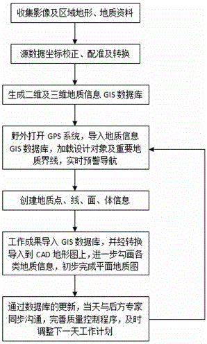
[0047] like figure 1 As shown, the engineering geological surveying and mapping method for portable intelligent equipment...


PUM


Abstract

The invention relates to a geological navigation and surveying and mapping working method using an Android tablet or a mobile phone, and belongs to the technical field of geological survey. The method of the present invention is based on the Andriod operating system, which consumes less memory than the Windows operating system software, and the equipment is convenient to carry, has many user groups, and the equipment price is relatively low and easy to popularize; utilizing GIS+GPS integration technology, field navigation and positioning are more efficient after coordinate processing Accurate; establish a dynamic and updateable two-dimensional or three-dimensional geological information GIS database. The geological record information includes audio and video information. The field operation is intuitive and simple, the content level is clear, and there is no repetition or omission. The recording method improves the efficiency of field work, and through synchronous communication with rear experts, it fills the gap in the systematic quality control procedures of field engineering geological surveying and mapping, and can also adjust the work plan in time, making the field geological surveying and mapping goals clearer.

Description

technical field [0001] The invention belongs to the technical field of geological survey, and in particular relates to a geological navigation and surveying and mapping working method using an android tablet or a mobile phone. Background technique [0002] The traditional field engineering geological surveying and mapping method is completed by paper medium + manual collection, which makes it difficult to carry and manage background data, written records, sketch maps, catalogue maps, geological photos and sampling information, narrow the survey field of view, and take time to find geological targets. laborious. The positioning accuracy of geological feature points, lines, surfaces and volumes is greatly affected by terrain accuracy and experience. There is almost no synchronization between on-site geological mapping and the rear, and quality control is difficult. To a certain extent, it is difficult to adapt to the increasingly severe market competition. At present, there a...

Claims


Application Information

Patent Timeline
Patent Type & Authority Patents(China)
IPC IPC(8): G01C21/00G01C7/00G06F17/30
CPCG01C7/00G01C21/32
Inventor 彭森良王昆李忠吴勇李天鹏
Owner POWER CHINA KUNMING ENG CORP LTD
Why Eureka
Try Eureka