Multi-common-turning-point lateral intersection traverse surveying method

A traverse measurement and point-turning technology, used in measuring instruments, measuring devices, mapping and navigation, etc., can solve problems such as low accuracy, insufficient reliability, and impact on processing results, and achieve the effect of ensuring measurement accuracy.

Active Publication Date: 2015-06-24
CHINA RAILWAY NO 2 ENG GRP CO LTD +1
View PDF3 Cites 10 Cited by
  • Summary
  • Abstract
  • Description
  • Claims
  • Application Information

AI Technical Summary

Problems solved by technology

This method is suitable for railway projects with straight lines and large-radius curves and long viewing distances. During tunnel construction, the section size of auxiliary guide pits such as inclined shafts or flat guides is narrower than that of normal tunnels, and such conductors cannot be laid because the width is not enough. Unable to adapt to changes in the extension path of underground caverns; if the wire form described in the present invention is modified, only one-sided points will be used, and the number of redundant observation points will be insufficient (the number of points used for transmission is only 2 to 3 points), the reliability is not enough, and the accuracy is not high ; At the same time, the method first checks the quality of the observation data during data processing, and then performs adjustment processing, without identifying and eliminating gross errors. Although there are a certain number of redundant observations, the processing results may still be affected by gross errors. Therefore, its application is still limited

Method used


Image

  • Multi-common-turning-point lateral intersection traverse surveying method
  • Multi-common-turning-point lateral intersection traverse surveying method
  • Multi-common-turning-point lateral intersection traverse surveying method

Examples


Embodiment 1

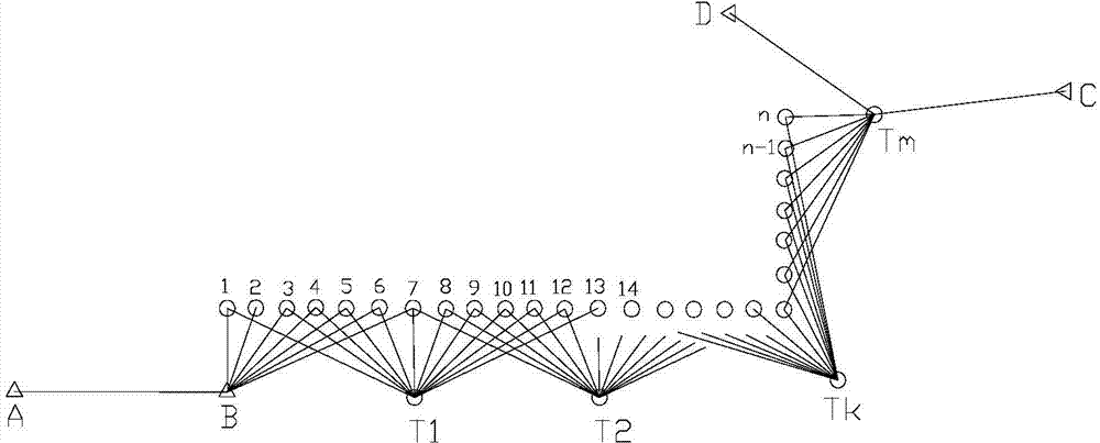
[0046] Refer to the attached figure 1 , a method for measuring lateral intersection wires with multiple common turning points, the specific steps are as follows:

[0047] 1. On the extension path from the starting side AB to the ending side CD of the wire, arrange the measuring station T according to the on-site visibility conditions 1 , T 2 ... T m , there is no need for centering, and on the other side of the connection line between adjacent stations, lay out 5 to 7 public turning points at roughly uniform intervals (this embodiment takes 7 as an example) 1, 2, 3...7, 8, ...n-5, n-4...n-1, n, the general measuring point and the public measuring point are respectively arranged on the pit walls on both sides of the tunnel;

[0048] 2. Level the high-precision intelligent total station Leica TCA2003 (nominal accuracy 0.5″, 1mm+10 -6 ×D km ) to set the mirror, center and level the target prism at point A, and set the target prism at the common turning point 1, 2, 3...7. If ...


PUM


Abstract

The invention belongs to a multi-common-turning-point lateral intersection traverse surveying method used for narrow underground caverns short in intervisibility distance and changed in traverse extending paths in the technical field of engineering surveying. The multi-common-turning-point lateral intersection traverse surveying method includes the steps of arranging at least two survey stations on a traverse extending path, arranging a plurality of public survey turning points on the other sides of connection lines among the survey stations uniformly, and adopting a high-precision total station for automatic observation; correcting surveyed slope distance and using the same to compute an independent coordinate for each survey station; computing three converting parameters between the independent coordinate and an integral coordinate of each public turning point between adjacent survey stations by the aid of a least-square indirect adjustment method and a robust estimation method, and converting the independent coordinates into integral coordinates. The multi-common-turning-point lateral intersection traverse surveying method has the advantages that enough redundant observation objects for traverse transferring and high precision are achieved, influence of lateral refraction is avoided, influence of error of centralization of an instrument and a prism during traverse transferring is eliminated, influences of gross observation error on an adjustment result are reduced, and the multi-common-turning-point lateral intersection traverse surveying method is suitable for places in difficult conditions, such as narrow underground caverns, curve paths and visualizing obstacles, and capable of improving precision and reliability of traverse transferring.

Description

technical field [0001] The invention relates to the technical field of engineering surveying, in particular to a measurement method for laterally intersecting wires with multiple common turning points in narrow underground caverns, short line-of-sight distances, and changing wire extension paths. Background technique [0002] Traverse measurement in engineering surveying is to set up mirrors on the traverse points of the line of sight, measure the angular distance between adjacent traverse points, use the angle to calculate the orientation of the extended traverse side, and use the distance and orientation to calculate the coordinates of the extended traverse points . In underground caverns and tunnel projects, at present, only the wire measurement method can be used to transmit coordinates and azimuths. Insufficient wire measurement accuracy will affect the accurate penetration of the tunnel, affect the progress and quality of the project, and even cause economic losses to ...

Claims


Application Information

Patent Timeline
Patent Type & Authority Applications(China)
IPC IPC(8): G01C15/00
CPCG01C15/00
Inventor 李学仕郭平
Owner CHINA RAILWAY NO 2 ENG GRP CO LTD
Why Eureka
Try Eureka