Complex plain river network area hydrological model processing method based on ArcGIS

A hydrological model, plain river network technology, applied in the direction of electrical digital data processing, special data processing applications, instruments, etc., can solve problems such as multiple breakpoints, inconsistencies, single tree-like river network, etc., to facilitate coupling and improve Simulation accuracy, effect of reducing channel segmentation

Active Publication Date: 2015-10-14
HOHAI UNIV
View PDF3 Cites 30 Cited by
  • Summary
  • Abstract
  • Description
  • Claims
  • Application Information

AI Technical Summary

Problems solved by technology

However, there is still no good solution on how to quickly and reasonably divide sub-basins in plain river network areas.
Some scholars have used the SWAT model to try to divide the sub-basins in the plain river network area, but the original "ring tree" combined river network must be treated as a single tree-like river network, which is inconsistent with the reality
Although the traditional method of dividing Thiessen polygons based on rainfall stations can quickly divide the research area into blocks, because there are many rivers in the plain river network area, and they are criss-crossed, after the Thiessen polygons divide the area into blocks, there will be multiple faults in one river. point, which is not conducive to the modeling of one-dimensional hydrodynamic model

Method used


Image

  • Complex plain river network area hydrological model processing method based on ArcGIS
  • Complex plain river network area hydrological model processing method based on ArcGIS
  • Complex plain river network area hydrological model processing method based on ArcGIS

Examples


Embodiment

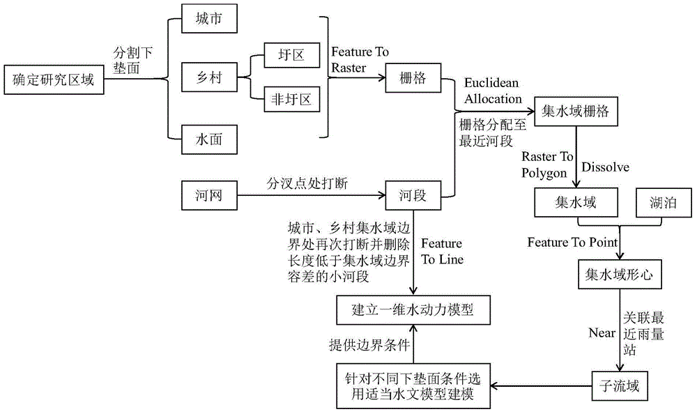
[0026] Example: A method for processing hydrological models in complex plain river network areas based on ArcGIS. The specific implementation process of catchment area division and rainfall station allocation is as follows figure 1 shown.

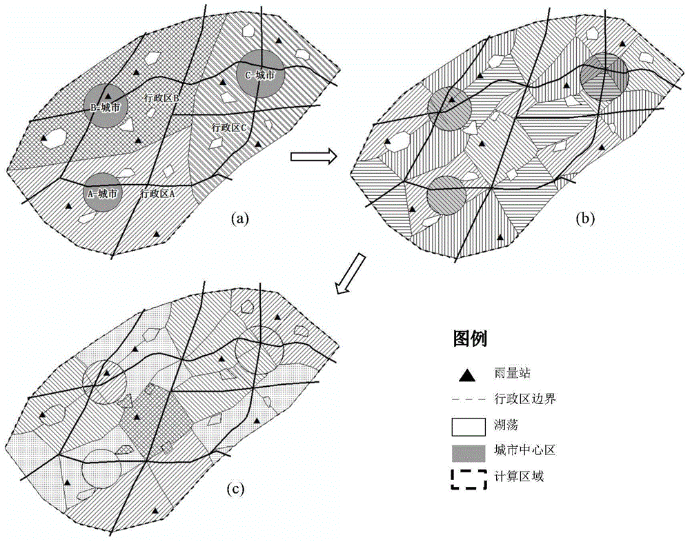
[0027] First, it is necessary to determine the boundary of the research area and convert the research area into a polygon element. like figure 2 As shown, where (a) indicates that there are three administrative areas A, B, and C in this embodiment, and cities (A-city, B-city, C-city), villages, lakes, river networks and Five types of elements of rainfall stations, in which the city center is a circle with the city center as the center and the same area as the urban built-up area.

[0028] Then, use the "Feature To Raster" tool of ArcGIS to discretize the urban and rural areas into rasters. In this embodiment, the allocated pixel size is set to 20m. At the same time, use the "Feature To Line" tool to interrupt the river network in the ca...


PUM


Abstract

The invention discloses a complex plain river network area hydrological model processing method based on ArcGIS. The method is characterized in that an underlying surface feature of a city, a country(comprising polder area and non-polder area) and water surface, and spatial distribution of the same can be distinguished in an aspect of sub-basin division, and thus a runoff generation and flow concentration process of different underlying surface types can be computed by using of different hydrological model; a river channel is interrupted at a river network bifurcated point and a city-country water region junction, a one-to-one correspondence of a catchment and a river reach is realized, thus coupling of hydrological model and hydrodynamic model is facilitated, and an unneccessary river channel segmentation in a modeling process can be reduced; a quick distribution of an underlying surface to a closest river channel is realized by an "Euclidean Allocation" tool; and adjustment of runoff process is performed by using a drainage modulus and an urban pipeline network maximum discharge capacity, the adjusted runoff process is further accorded with a hydrological rule in the plain area, and a simulation accuracy can be improved theoretically.

Description

technical field [0001] The invention relates to the field of hydrology, in particular to a method for processing hydrological models in complex plain river network areas. Background technique [0002] Hydrological models can be divided into distributed hydrological models and lumped hydrological models in terms of their modeling principles. Distributed hydrological models are generally applied to hilly areas with large terrain elevation fluctuations. For plain river network areas, since there is no obvious boundary of water diversion and catchment, lumped hydrological models are generally used for calculation of flow production and confluence. With the development of computational hydraulics, the coupling of one-dimensional river network hydrodynamic model and lumped hydrological model to solve the hydrological and hydrodynamic process in complex plain river network areas has been more and more applied, such as the MIKE11-NAM model and the Taihu Basin model. wait. However...

Claims


Application Information

Patent Timeline
Patent Type & Authority Applications(China)
IPC IPC(8): G06F17/50G06F19/00
Inventor 胡孜军王玲玲唐洪武焦创曾诚朱海
Owner HOHAI UNIV
Why Eureka
Try Eureka