
Lake management integrated information system

A technology of comprehensive information and basic geographic information, applied in data processing applications, instruments, climate change adaptation, etc., can solve the problems of lake comprehensive management optimization and improvement, management asynchronous, low management efficiency, etc., to improve reporting processing efficiency, The effect of improving efficiency and level and improving the level of informatization

Inactive Publication Date: 2016-01-13
江苏省泰州引江河管理处
View PDF2 Cites 6 Cited by
  • Summary
  • Abstract
  • Description
  • Claims
  • Application Information

AI Technical Summary

Problems solved by technology

[0002] In recent years, as people pay more and more attention to lake management, the content of lake management has been continuously enriched, and management measures have been gradually improved, such as carrying out lake inspections, strengthening supervision of enclosures, dredging and removing obstacles, and regularly carrying out lake management. However, there is currently a lack of an effective comprehensive information platform for lake management in lake management, and there are still several problems in practice: first, the management content and measures are isolated and out of touch with each other, and the management efficiency is low; There is a lack of information sharing and timely update of information among different levels of lake management units, and the management is not synchronized; third, there is a lack of effective management of historical data of lake management, which cannot provide continuous and effective data support for lake management research; Predict the amount of flood detention in lake groups, providing technical support for scientific flood control and drainage scheduling
This patent document emphasizes the technology of manual inspection and remote transmission, but does not optimize and improve the comprehensive management of the lake

Method used


Image

  • Lake management integrated information system
  • Lake management integrated information system
  • Lake management integrated information system

Examples


Embodiment Construction

[0025] The present invention will be described in further detail below in conjunction with the accompanying drawings and embodiments.

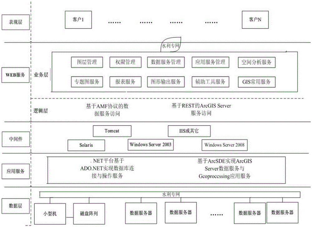
[0026] This embodiment is based on the ArcGISServer platform, and the overall architecture is as follows figure 1 As shown, using computer network communication and data processing technology, the data layer mainly refers to the water conservancy geographic database involved in the project, which is the bottom layer (base) of the system, that is, the database server. The service layer mainly refers to the connection interface between various application services and the data layer, mainly including various professional application components, service interfaces, data exchange interfaces, etc. (including figure 1 The application service, middleware, and WEB service in the middle three layers, the middleware is the operating system corresponding to the database server, GIS application server, and WEB server), and is the middle layer of the syste...


PUM


Abstract

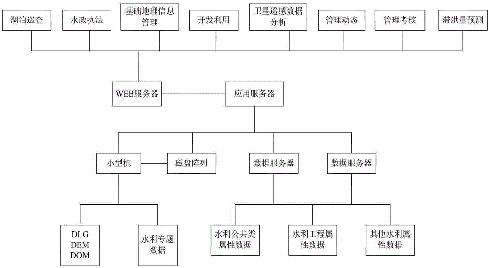
The invention discloses a lake management integrated information system. The system comprises a lake patrol subsystem, a water administration law enforcement subsystem, a basic geographic information management subsystem, a development and utilization subsystem, a satellite remote sensing data analysis subsystem, a management dynamic subsystem, a management assessment subsystem, and a flood detention volume prediction subsystem. According to the system, lake patrol time and route, lake illegal situation and handling progress, various basic geographical data within the range of lake management and lake development and utilization situations can be checked; changes and trends of a lake can be mastered by analyzing satellite remote sensing map data; management interaction and management assessment are performed by lake management agencies of different management levels; flood storage and detention volume is predicted; and classification statistics, query and other operations are performed on related data according to needs, so that current management situation can be effectively improved and the efficiency and level of lake management can be greatly improved.

Description

technical field [0001] The invention relates to a lake management system, which belongs to the application technology combining GPS, GIS and lake management. Background technique [0002] In recent years, as people pay more and more attention to lake management, the content of lake management has been continuously enriched, and management measures have been gradually improved, such as carrying out lake inspections, strengthening supervision of enclosures, dredging and removing obstacles, and regularly carrying out lake management. assessment work, etc., but there is currently a lack of an effective comprehensive information platform for lake management in lake management. There are still several problems in practice: first, the management content and measures are isolated and out of touch with each other, and the management efficiency is low; second, There is a lack of information sharing and timely update of information among different levels of lake management units, and t...

Claims


Application Information

Patent Timeline
IPC IPC(8): G06Q10/06G06Q50/00
CPCY02A10/40
Inventor 张加雪钱福军李频王冬梅许靖波夏卫中王琴陈志宏钱江赵林章
Owner 江苏省泰州引江河管理处
Learn More