High-dynamic GNSS carrier wave signal tracking method and system thereof

A carrier signal, high dynamic technology, applied in the field of satellite navigation, can solve the problems of affecting tracking performance, difficulty in accurate detection of dynamic level, and large amount of calculation.

Inactive Publication Date: 2016-06-22
SHANGHAI JIAO TONG UNIV +1
View PDF4 Cites 3 Cited by
  • Summary
  • Abstract
  • Description
  • Claims
  • Application Information

AI Technical Summary

Problems solved by technology

Therefore, no matter relying on the traditional tracking method in the frequency domain or the vector tracking method in the time domain, because only the tracking in a single domain is considered, the uncertainty of signal estimation will affect the tracking performance;
[0007] (2) Difficulty in accurate detection of dynamic level: Whether relying on the frequency estimation in the loop or the IMU in the strapdown inertial navigation system, there is a problem that the carrier

Method used


Image

  • High-dynamic GNSS carrier wave signal tracking method and system thereof
  • High-dynamic GNSS carrier wave signal tracking method and system thereof
  • High-dynamic GNSS carrier wave signal tracking method and system thereof

Examples


Embodiment Construction

[0069] In order to make the above objects, features and advantages of the present invention more comprehensible, specific implementations of the present invention will be described in detail below in conjunction with the accompanying drawings.

[0070] In the following description, numerous specific details are set forth in order to provide a thorough understanding of the present invention. However, the present invention can be implemented in many other ways different from those described here, and those skilled in the art can make similar extensions without violating the connotation of the present invention, so the present invention is not limited by the specific implementations disclosed below.

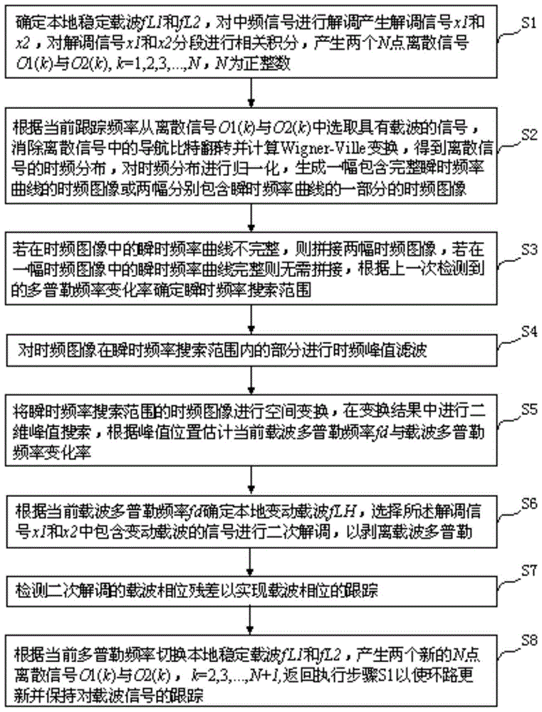
[0071] figure 1 Show the highly dynamic GNSS carrier signal tracking method of the embodiment of the present invention, comprise the following steps:

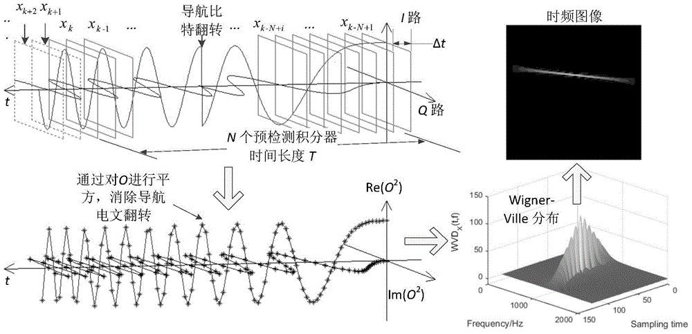
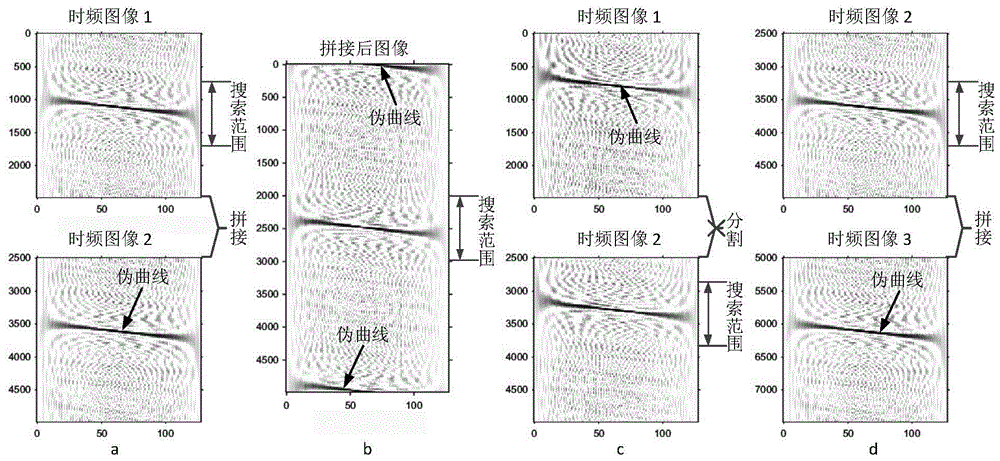
[0072] S1: Determine local stable carrier f L1 and f L2 , to demodulate the intermediate frequency signal to generate demodulate...


PUM


Abstract

The invention provides a high-dynamic GNSS carrier wave signal tracking method. A time frequency image can simultaneously combine a time domain and a frequency domain to analyze a signal. On a principle, a contradiction between a frequency resolution and a time resolution is balanced and signal nondeterminacy caused by high dynamic is limited in several pixels. Therefore, different from a traditional tracking method, a dynamic tracking ability in the invention is not limited by a loop band width so that a receiver can track a super high dynamic carrier wave signal, and a usage scope of a GNSS receiver based on Big Dipper/GPS is expanded.

Description

technical field [0001] The invention relates to the technical field of satellite navigation, in particular to a high dynamic GNSS carrier signal tracking method and system. Background technique [0002] GNSS (Global Navigation Satellite System) is the Global Navigation Satellite System. A satellite navigation receiver acquires and tracks the signals of multiple GNSS satellites and then demodulates the navigation data modulated therein. The satellite navigation receiver uses the ranging code to calculate the relative distance between the GNSS satellite and the user, uses the ephemeris data in the navigation data to solve the satellite position and time model, and then calculates the user's position. [0003] Navigation using GNSS signals (such as GPS (Global Positioning System), Beidou, GLONASS (Global Satellite Navigation System), etc.) has been widely used in space low-orbit satellites, missiles, and ground targets. When the carrier is running in an environment with high ...

Claims


Application Information

Patent Timeline
IPC IPC(8): G01S19/29
CPCG01S19/29
Inventor 夏轩仲科伟赵健康臧中原许东欢毋蒙
Owner SHANGHAI JIAO TONG UNIV
Why Eureka
Try Eureka