Radar altimeter assistance method aiming to inertial navigation

A technology of inertial navigation and altimeter, applied in the field of navigation, can solve the problems of reducing the cross-coupling effect of accelerometers, not completely autonomous navigation, etc.

Inactive Publication Date: 2016-08-10
BEIHANG UNIV
View PDF8 Cites 9 Cited by
  • Summary
  • Abstract
  • Description
  • Claims
  • Application Information

AI Technical Summary

Problems solved by technology

[0004] How to improve navigation accuracy during autonomous flight has always been a hot research issue. The combination of inertial navigation and star sensors is a commonly used autonomous navigation solution. Improving the accuracy of the reference coordinate system of the inertial navigation system and reducing the cross-coupling effect of the accelerometer can reduce the speed and position errors caus

Method used


Image

  • Radar altimeter assistance method aiming to inertial navigation
  • Radar altimeter assistance method aiming to inertial navigation
  • Radar altimeter assistance method aiming to inertial navigation

Examples


Embodiment Construction

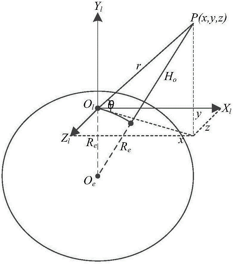
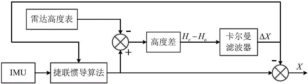
[0010] For strapdown inertial navigation system (SINS), utilize the present invention based on the system quantity measurement that radar altimeter (RA, Radar Altimeter) obtains to set up SINS / RA integrated navigation system, adopt the indirect feedback correction type Kalman filter, filter result feedback on the one hand The inertial navigation system corrects the deviation, and on the other hand corrects the state output at the current moment, which realizes the estimation of the aircraft position and reduces the position drift error.

[0011] (1) Establish a measurement model

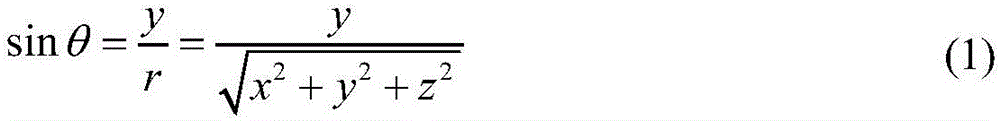
[0012] Such as figure 1 As shown, R e is the radius of the earth. In the launching inertial coordinate system O l -X l Y l Z l (hereinafter referred to as the l system, and as a navigation coordinate system), the angle θ between the position vector r and the horizontal plane of the launching point satisfies

[0013] s i n θ = ...


PUM


Abstract

The invention provides a radar altimeter assistance method aiming to inertial navigation. In the method, a measurement quantity is constructed in the manner of calculating earth core altitude of an air vehicle according to position vectors outputted by the inertial navigation, calculating earth core altitude minus earth ellipsoidal radius to obtain the calculated altitude height of the air vehicle, obtaining observed altitude height by means of a measurement value from the radar altimeter with other algorithms, and calculating altitude height minus the observed altitude height to obtain a difference as the measurement quantity, and finally deriving a total differential equation of the measurement quantity. The invention provides a particular embodiment, wherein a strapdown inertial navigation/radar altimeter combined navigation system is formed on the basis of the measurement quantity. Estimation on position error status quantity is achieved, diffusion of position error is inhibited and positioning precision is increased through an indirect method Kalman filtering with feedback compensation.

Description

(1) Technical field [0001] The invention provides a radar altimeter auxiliary method for inertial navigation, belongs to the field of navigation, and provides an effective method for improving the navigation and positioning accuracy of aircraft. (2) Background technology [0002] As a completely autonomous navigation system, the basic principle of inertial navigation is to use the rotation and translation information of the sensitive carrier of the gyroscope and accelerometer, and complete the calculation of the attitude, speed and position of the aircraft through formula programming. It has continuous output, strong reliability, It has obvious advantages such as high short-term accuracy, but it also has the disadvantage that the error diverges with time. [0003] A radar altimeter is an active distance sensor. Radar has different systems, such as lidar or radio radar, to measure the distance between the aircraft and a target object. With the rapid development of guidance, ...

Claims


Application Information

Patent Timeline
IPC IPC(8): G01C21/16G01S13/86
CPCG01C21/165G01S13/86
Inventor 王海涌高自谦
Owner BEIHANG UNIV
Why Eureka
Try Eureka