Fire point detection method based on Landsat-8 landsat data

A satellite data and detection method technology, applied in the field of remote sensing, can solve problems such as difficulty in obtaining better detection results, and achieve the effects of improving spatial resolution, increasing detection capabilities, and eliminating interference

Active Publication Date: 2016-10-12
INST OF REMOTE SENSING & DIGITAL EARTH CHINESE ACADEMY OF SCI
View PDF4 Cites 19 Cited by
  • Summary
  • Abstract
  • Description
  • Claims
  • Application Information

AI Technical Summary

Problems solved by technology

However, the above-mentioned fire point detection algorithm is limited by the spatial resolution, and it is difficult to achieve better detection for

Method used


Image

  • Fire point detection method based on Landsat-8 landsat data
  • Fire point detection method based on Landsat-8 landsat data
  • Fire point detection method based on Landsat-8 landsat data

Examples


Embodiment Construction

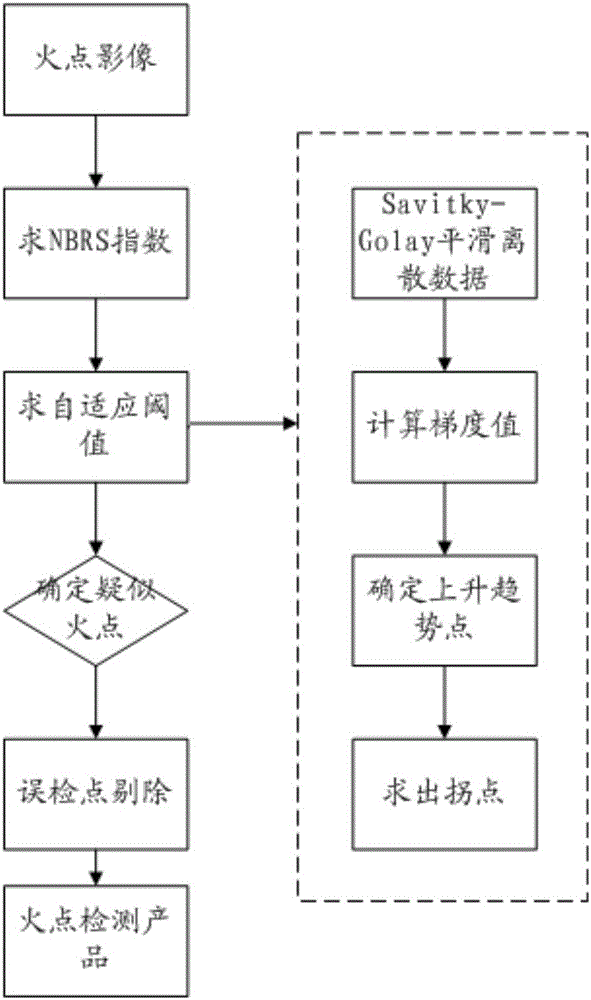
[0052] In order to make the object, technical solution and advantages of the present invention clearer, the present invention will be further described in detail below in conjunction with the accompanying drawings. It should be understood that the specific embodiments described here are only used to explain the present invention, and are not intended to limit the present invention.

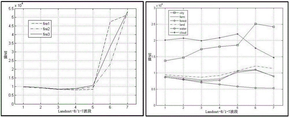
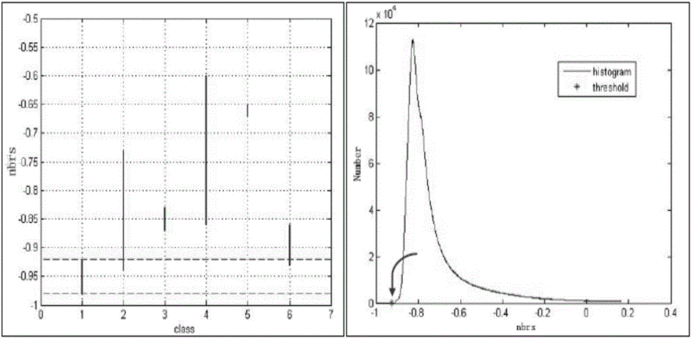
[0053] In optical remote sensing, without considering the influence of various radiation errors, the DN value in the image is jointly determined by the emissivity and reflectivity of the ground object. According to the reflection and emission radiation energy characteristics of ground objects in different spectral intervals, the characteristics of abnormal ground objects can be separated through band operation. For example, the improved normalized combustion index is used in this paper to extract fire points. In the band selection of the fire point detection algorithm, most algorithms choose to us...


PUM


Abstract

The invention discloses a fire point detection method based on Landsat-8 landsat data, and relates to the field of remote sensing technologies. According to the method, by using data of a Landsat 8OLI sensor with a spatial resolution of 30m, suspected fire points are extracted by self-adaptively determining a threshold by using an improved normalization combustion index NBRS result according to spectrum characters of a high-temperature fire point at a near-infrared band and a short wave infrared band, then mistakenly detected points are removed by further using a peak relation of the high-temperature fire point at the short wave infrared band, and thus a final fire point product is obtained. According to the algorithm provided by the invention, the fire point of which the area is about 10% of a pixel area can be detected, the interference of clouds and buildings can be effectively eliminated, and an accuracy rate about 90% can also be achieved while ensuring a relatively low omission rate; compared with the traditional algorithm, the algorithm provided by the invention is greatly improved in fire point extraction accuracy.

Description

technical field [0001] The invention relates to the technical field of remote sensing, in particular to a fire point detection method based on Landsat-8 land satellite data. Background technique [0002] The rapid development of remote sensing technology provides powerful help for fire detection, positioning and post-disaster assessment, such as MODIS with medium and low spatial resolution (500m~1km), NOAA / AVHRR and other satellites, with short reentry period and fast early warning, Its fire point product data has been widely and successfully applied in fire monitoring and early warning. Huodian product algorithms based on these satellite data are relatively mature, mainly including: single-channel threshold method, multi-channel threshold method and effective background pixel method. in: [0003] 1. The single-channel threshold method uses the mid-infrared band data, inverts the temperature data according to the DN value of the image, and divides the temperature products ...

Claims


Application Information

Patent Timeline
IPC IPC(8): G06T7/00
CPCG06T2207/10032G06T2207/30232
Inventor 杨进何阳李信鹏梁龙彬陈甫
Owner INST OF REMOTE SENSING & DIGITAL EARTH CHINESE ACADEMY OF SCI
Why Eureka
Try Eureka