
Multi-source combined positioning method based on adaptive weighted mixing Kalman filtering

A Kalman filter and adaptive weighting technology, which is applied in satellite radio beacon positioning system, radio wave measurement system, navigation through speed/acceleration measurement, etc., can solve the problems of positioning accuracy influence, positioning error accumulation, etc., and achieve accurate The effect of positioning

Active Publication Date: 2016-11-09
SHANDONG UNIV
View PDF6 Cites 22 Cited by
  • Summary
  • Abstract
  • Description
  • Claims
  • Application Information

AI Technical Summary

Problems solved by technology

Although RFID has the advantages of cheap price and high accuracy in short distances, as the positioning distance increases, the positioning accuracy will be greatly affected
(3) The positioning of the inertial navigation unit (IMU) uses accelerometers and gyroscopes for positioning, does not require auxiliary signal base stations, and has the advantages of being completely autonomous and not affected by the external environment, but the positioning error of the IMU will accumulate over time Shortcomings
However, the above positioning devices and methods still cannot solve or avoid the shortcomings and deficiencies of each positioning technology itself.

Method used


Image

  • Multi-source combined positioning method based on adaptive weighted mixing Kalman filtering
  • Multi-source combined positioning method based on adaptive weighted mixing Kalman filtering
  • Multi-source combined positioning method based on adaptive weighted mixing Kalman filtering

Examples


Embodiment 1

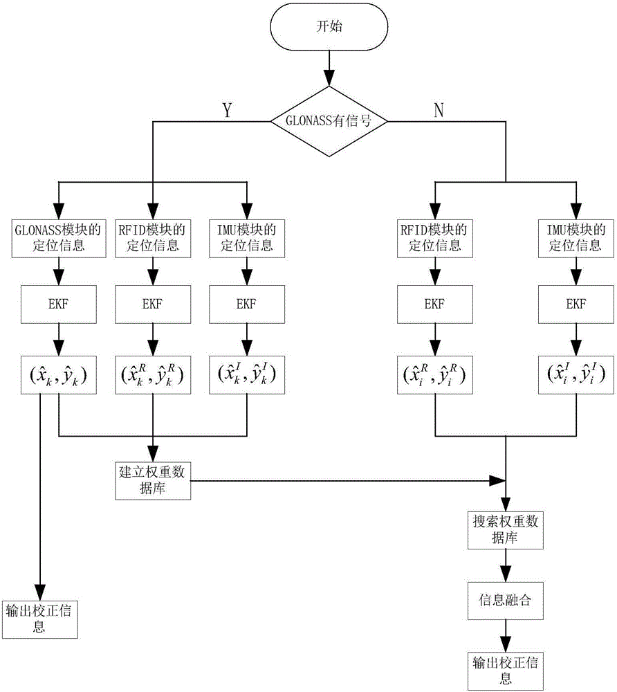
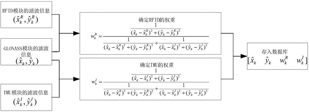
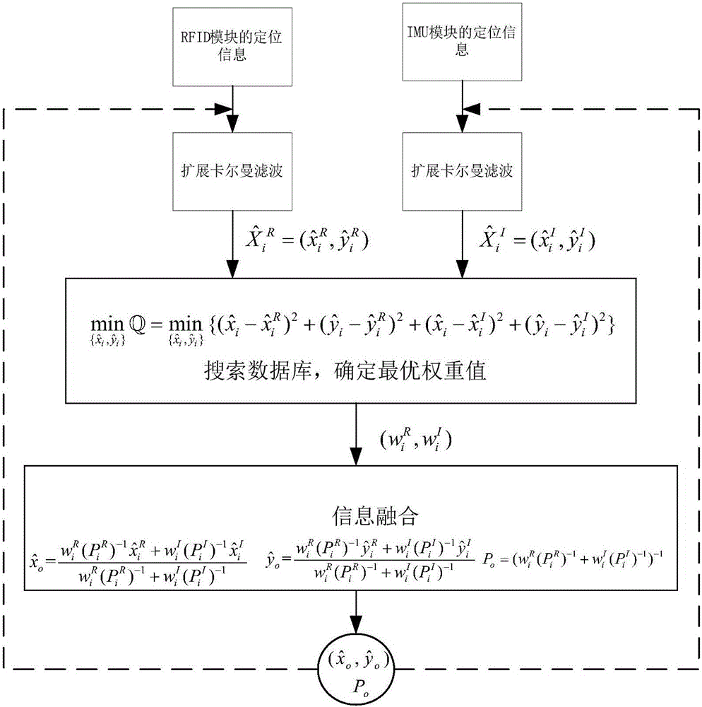
[0082] like Figure 1-3 shown.

[0083] A multi-source joint positioning method based on adaptive weighted hybrid Kalman filter, comprising the following steps:

[0084] 1) The receiver receives the signals of GNSS, RFID, and IMU respectively, and judges whether the GNSS signal is interfered;

[0085] 2) If the GNSS signal is not disturbed, to locate the coordinates of the target is the state vector, with Establish the GNSS system motion model and GNSS observation model for the observation vector, and obtain the optimal estimation of the GNSS state through the extended Kalman filter calculation where r 1 、r 2 、r 3 are the distances from the coordinates of the positioning target measured by GNSS to the three base stations; x k ,y k Respectively, under the WGS-84 coordinates, at time k, the eastward and northward coordinates of the Gaussian projection plane;

[0086] 3) To locate the coordinates of the target is the state vector, with For the RFID observation vec...

Embodiment 2

[0093] The multi-source joint positioning method based on adaptive weighted hybrid Kalman filter as described in Embodiment 1, the difference is that the formula of the GNSS system motion model:

[0094] X k G = f ( X k - 1 G , k - 1 ) + Γ G ( X k - 1 G , k - 1 ) W k - 1 G

[0095] in, d k is the displacement of the positioning target from time k-1 to time k, w k-1 is the headin...

Embodiment 3

[0097] The multi-source joint positioning method based on adaptive weighted hybrid Kalman filter as described in Embodiment 1, the difference is that the formula of the GNSS observation model:

[0098] Z k G = h ( X k G , k ) + V k G

[0099] in, (x 1 ,y 1 ), (x 2 ,y 2 ), (x 3 ,y 3 ) are the coordinates of the three base stations participating in the positioning; r 1 、r 2 、r 3 are the distances from the coordinates of the positioning target measured by GNSS to the three base stations; is a zero-mean observed white noise sequence, in, is the variance of the observation noise sequence.


PUM


Abstract

The invention relates to a multi-source combined positioning method based on adaptive weighted mixing Kalman filtering. The method performs combined positioning via GNSS / RFID / IMU. When a GNSS signal loses lock, the method may perform weighted adaptive Kalman filtering on IMU and RFID positioning information by searching a weight database and outputs accurate positioning. The multi-source combined positioning method based on adaptive weighted mixing Kalman filtering increases GNSS positioning precision by using an expanded Kalman filtering algorithm, improves blind area positioning precision by using a multi-sensor combined positioning algorithm, overcomes influences due to the shielding of high buildings, and reduces weight computational difficulty and increases arithmetic speed by establishing a weight database.

Description

technical field [0001] The invention relates to a multi-source joint positioning method based on self-adaptive weighted hybrid Kalman filter, and belongs to the technical field of multi-source joint positioning. Background technique [0002] The method of multi-source information fusion has been widely used in aerospace engineering, navigation safety, UAV navigation and positioning and other fields. A single sensor can only cover a specific area in the environment in space, and if a single sensor is used alone, the entire system may lose measurement data due to a single sensor failure, resulting in paralysis or collapse of the entire system and affecting positioning accuracy , so multi-sensor joint positioning is playing an increasingly important role in improving positioning accuracy. [0003] The existing main positioning technologies are as follows: (1) Global Navigation Satellite System (Global Navigation Satellite System, GNSS), which refers to all satellite navigation...

Claims


Application Information

Patent Timeline
IPC IPC(8): G01S19/48G01S19/49G01C21/16
CPCG01C21/165G01S19/48G01S19/49
Inventor 熊海良唐娟马丕明朱维红杜正锋
Owner SHANDONG UNIV
Learn More