Frequency-domain aeroelectromagnetic method 2.5 dimension band landform inversion method

An airborne electromagnetic and frequency domain technology, applied in the field of airborne geophysical prospecting

Active Publication Date: 2016-12-07
JILIN UNIV +1
View PDF6 Cites 16 Cited by
  • Summary
  • Abstract
  • Description
  • Claims
  • Application Information

AI Technical Summary

Problems solved by technology

[0005] The technical problem to be solved by the present invention is to provide a 2.5-dimensional forward and inversion data processing method of the frequency-domain airborne electromagnetic method under the condition of terrain fluctuations, solve

Method used


Image

  • Frequency-domain aeroelectromagnetic method 2.5 dimension band landform inversion method
  • Frequency-domain aeroelectromagnetic method 2.5 dimension band landform inversion method
  • Frequency-domain aeroelectromagnetic method 2.5 dimension band landform inversion method

Examples


Embodiment 1

[0084] A frequency-domain airborne electromagnetic method 2.5-dimensional belt terrain inversion method, comprising the following steps, that is, the inversion process is as follows:

[0085] 1) Define the objective function, set the number of iterations to i=0, the fitting accuracy and the maximum number of iterations, and input the initial model and inversion data;

[0086] 2) Carry out forward calculation, solve the forward equation KF=b to obtain the secondary magnetic field H x and H z ;

[0087] 3) Calculate the fitting error, if it reaches the set accuracy or the maximum number of iterations, exit the calculation, otherwise continue;

[0088] 4) Calculate the Jacobian matrix with quasi-forward modeling to obtain the model update step size;

[0089] 5) Update model parameters, m k+1 = m k +Δm.

[0090] In step 1), the defined objective function is shown in formula 1,

[0091] Φ ( m ) = ...

Embodiment 2

[0144] The forward modeling calculation carried out in step 2), the process of forward modeling accuracy verification is as follows:

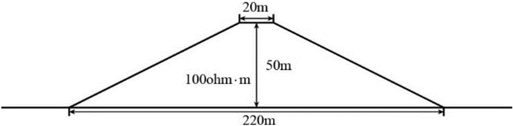
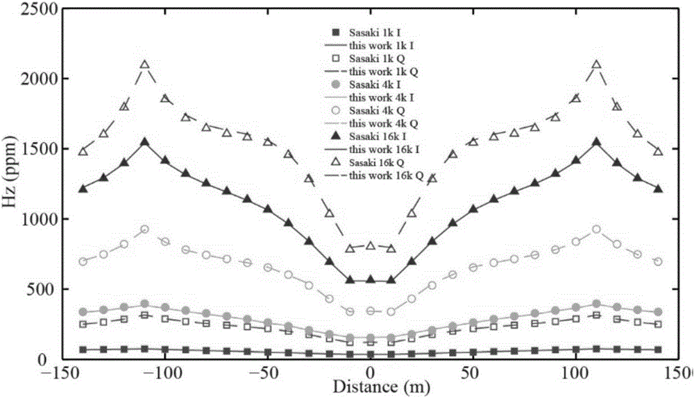
[0145] In order to verify the correctness of this algorithm, the same two-dimensional trapezoidal mountain model as Sasaki (Yutaka et al., 2003) is used, as shown in Figure (2). The top and bottom of the trapezoidal mountain are 20m and 220m respectively, the distance from the top to the bottom of the mountain is 50m, the slope is 26.5°, and the resistivity of the medium is 100ohm-m. The simulation area is divided into 41×41×41 grids in the x, y and z directions, the grid size in the middle area is 10m×10m×10m, and the maximum grid size at the boundary is 1280m×1280m×1280m. The horizontal coplanar device (HCP) is used for calculation, the distance between the transmitting and receiving coils is 30m from the ground, and the transmitting and receiving distance is 10m, and three frequencies of 1k Hz, 4k Hz and 16kHz are used for calculation. The ...

Embodiment 3

[0149] Design a low-resistance combined model of hills, as shown in Figure (9). There are two low-resistance anomalous bodies buried in the uniform half-space, the resistivity of the anomalous body is 10ohm-m, and the background resistivity is 300ohm-m. The top of the mountain is 20m wide,

[0150] The distance from the foot of the mountain is 50m, and the slope is 26.6°. We simulate undulating terrain by varying the z-coordinate of the mesh. The horizontal coplanar (HCP) device was used for forward modeling, and four frequencies were used, namely 1000Hz, 2700Hz, 7400Hz and 20000Hz. The transmitting and receiving distance of the coil is 8m, the height from the ground is 20m, the point distance is 10m, and there are 51 measuring points in total. The simulation area is divided into 69×34×29 grids, the grid size of the middle area is 10m×10m×10m, and the maximum grid size of the expanded border area is 1280m×1280m×1280m. The forward modeling results of the horizontal coplanar...


PUM


Abstract

The invention discloses a frequency-domain aeroelectromagnetic method 2.5 dimension band landform inversion method. The method comprises the following steps of 1) defining a target function, setting iteration times i, fitting precision and the maximum iteration time and inputting an initial model and inversion data, wherein the i equals to 0; 2) carrying out forward calculation, calculating a forward equation KF=b so as to acquire secondary magnetic fields Hx and Hz; 3) calculating a fitting error, if the fitting error reaches setting precision or the maximum iteration time, quitting calculation, otherwise, continuously calculating; 4) using pseudo-forward modeling to calculate a Jacobian matrix and acquiring a model updating step; and 5) updating a model parameter and satisfying the following equation: mk+1=mk+deltam. In the invention, band landform inversion is considered; a landform influence is eliminated; and frequency-domain aeroelectromagnetic method 2.5 dimension inversion under a fluctuating land surface condition is realized. An effective calculating method is provided for mountain-area aeroelectromagnetic data processing and interpretation.

Description

technical field [0001] The invention belongs to the field of aeronautical geophysical prospecting, and in particular relates to a 2.5-dimensional forward and inversion data processing system of frequency-domain airborne electromagnetic method under the condition of terrain undulation. Background technique [0002] As an important geophysical prospecting method, the frequency domain airborne electromagnetic method has been widely used in many fields such as mineral prospecting, geological mapping, groundwater resource prospecting and environmental monitoring. Airborne electromagnetic methods are often operated in mountainous areas. The terrain in these areas has large fluctuations, which have a serious impact on the airborne electromagnetic response. Ignoring the terrain effect will cause great errors in the interpretation of airborne electromagnetic data. Only with terrain inversion can the terrain influence be eliminated. Therefore, it is very necessary to carry out airborn...

Claims


Application Information

Patent Timeline
IPC IPC(8): G01V3/38
CPCG01V3/38
Inventor 习建军曾昭发李文奔郝建奇崔丹丹
Owner JILIN UNIV
Why Eureka
Try Eureka