Head real-time control system and method for small unmanned aerial vehicle for land survey

A real-time control system and technology of small drones, applied in the direction of using feedback control, etc., can solve problems such as blurred image focus and processing difficulty, and achieve the effect of reducing difficulty

Active Publication Date: 2016-12-07
SOUTHEAST UNIV
View PDF6 Cites 21 Cited by
  • Summary
  • Abstract
  • Description
  • Claims
  • Application Information

AI Technical Summary

Problems solved by technology

[0005] During the flight of the UAV, it is necessary to take photos and collect land information in real time. During the image collection process, its flight attitude will be changed due to the influence of wind, body shake and path changes. In some cases, the captured image will have serious focus blur, which will cause great difficulty

Method used


Image

  • Head real-time control system and method for small unmanned aerial vehicle for land survey
  • Head real-time control system and method for small unmanned aerial vehicle for land survey
  • Head real-time control system and method for small unmanned aerial vehicle for land survey

Examples


Embodiment

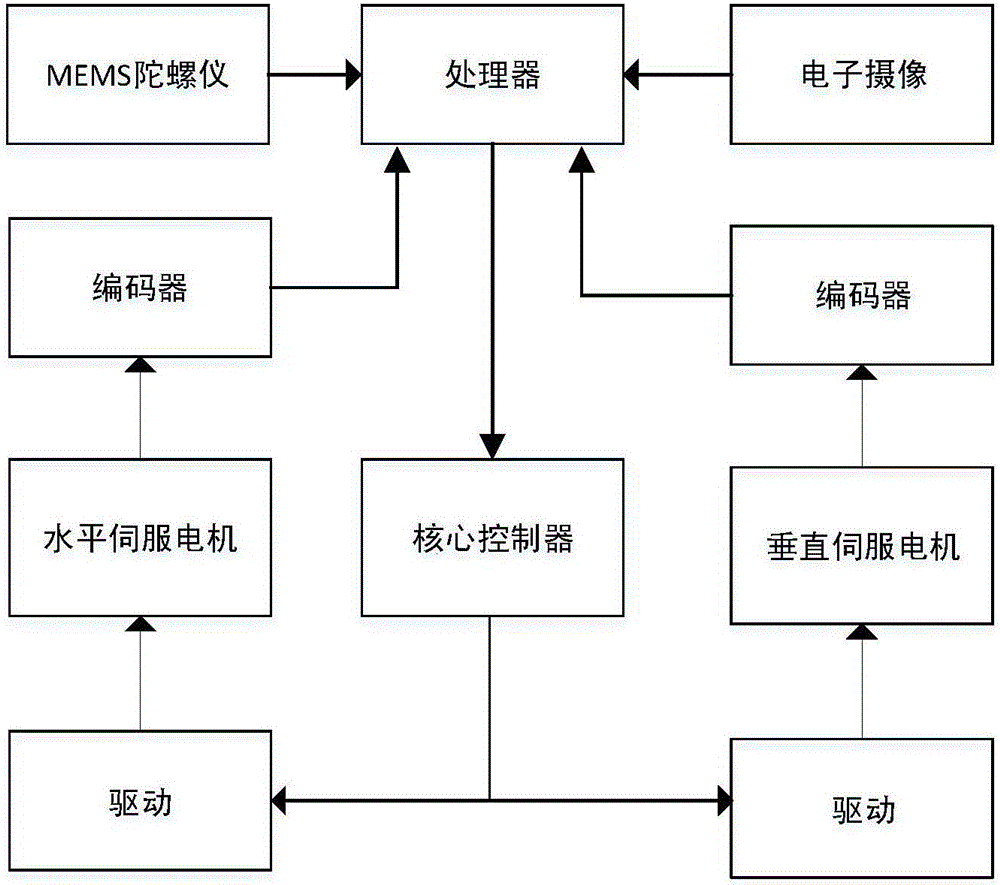
[0047] The control system of the present invention is installed at a suitable position above and below the frame of the UAV, which can control three brushless motors perpendicular to each other, so as to set up a control platform for the camera as a pan-tilt. It is also necessary to set up the minimum flight control system pixhawk on the drone. The pixhawk comes with MEMS sensors and can stabilize the stability of the fuselage to a certain extent.

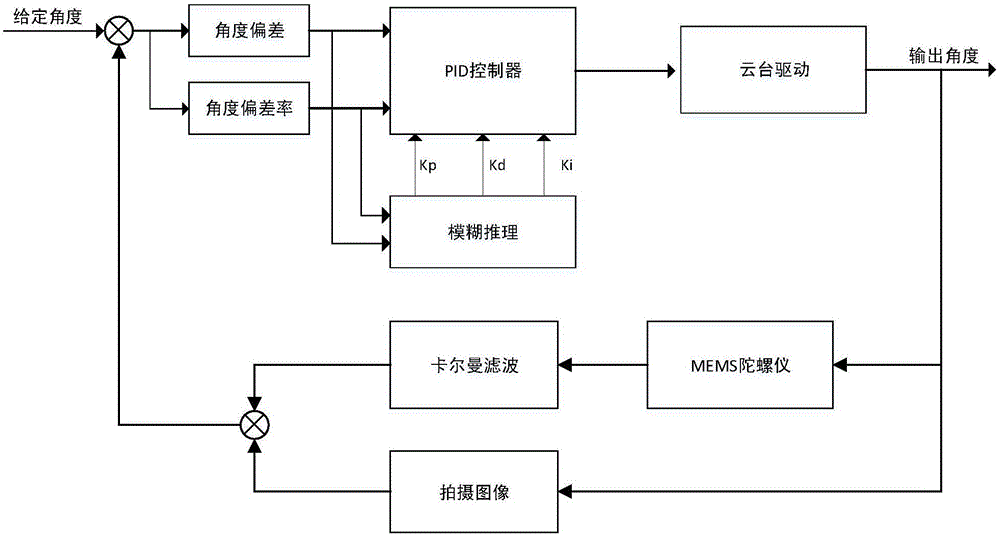
[0048] Calibrate and place the reference point in the area to be measured, and use it as the reference point for the calculation of the inclination angle of the monocular camera.

[0049] After the preparatory work is completed, the drone is lifted into the air and the monocular camera calculates the inclination angle of the camera according to the reference point during the vertical aerial photography. Acceleration, velocity, and tilt angle, and the tilt angle is filtered by Kalman to reduce the influence of the white noise error ...


PUM


Abstract

The invention discloses a head real-time control system and method for a small unmanned aerial vehicle for a land survey. The head real-time control system comprises a head three-axis drive system, a video camera, an MEMS sensor, a processor and a core controller; the core controller controls the head three-axis drive system to conduct adjustment according to the angle, needing to be adjusted, of the head three-axis device system, wherein the angle is obtained through the processor. According to the head real-time control system and method for the small unmanned aerial vehicle for the land survey, the unmanned aerial vehicle for aerial surveying can meet ideal precision requirements in flight attitude control and head stability control; particularly, a unique online image angle calculation method is added, a head is controlled really according to actually photographed image features, and the unmanned aerial vehicle can adapt to various complex environments; meanwhile, fuzzy PID control is combined with self-adaptive Kalman filter, a stable image can be obtained, and therefore the difficulty of post processing of the image is reduced.

Description

technical field [0001] The invention relates to unmanned aerial vehicle technology and cloud platform control technology, in particular to an image-based angle measurement system. Background technique [0002] Land is the foundation of a country and occupies a very important position in national economic development and infrastructure construction. With the rapid development of the national economy, our government urgently needs a technical means that can accurately and efficiently complete the collection and mapping of land information. At present, my country's urban land survey mainly uses the GIS system of the second national land survey, GPS-RTK system combined with inertial navigation and optical total station. The original detection methods are not flexible enough, not accurate enough, and affected by topography, affecting the efficiency of land surveys. [0003] At present, the research and development of military drones has gradually entered the stage of actual com...

Claims


Application Information

Patent Timeline
IPC IPC(8): G05D3/12
CPCG05D3/12
Inventor 冯悠扬王庆阳媛翟海洋马群
Owner SOUTHEAST UNIV
Why Eureka
Try Eureka