Integrated GPS and GLONAS positioning time service method

A GPS system and algorithm technology, applied in the field of positioning and timing of GPS and GLONASS, can solve the problems of long time, inability to cooperate with each other, and the accuracy cannot immediately reach the preset index accuracy, so as to improve the performance, improve the timing accuracy, and reduce the first time The effect of positioning time

Inactive Publication Date: 2017-02-15
重庆九洲星熠导航设备有限公司
View PDF5 Cites 4 Cited by
  • Summary
  • Abstract
  • Description
  • Claims
  • Application Information

AI Technical Summary

Problems solved by technology

Most of the existing technologies are GPS and GLONASS system satellite positioning results respectively calculated and then combined for positioning. Compared with the integrated GPS and GLONASS positioning and timing technology, the main disadvantages are as follows: 1. From the perspective of the first positioning time, the existing technology needs to wait GPS and GLONASS systems are combined after solving separately, and they cannot cooperate with each other in the solving process, which takes a long time; 2. From the perspective of timing accuracy, the accuracy of the existing technology cannot immediately reach the preset time when the timing is effective The accuracy of the index needs to reach the preset index accuracy after the combined algorithm of GPS and GLONASS has been operated for a certain period of time. For this reason, we have invented a method that integrates GPS and GLONASS positioning and timing

Method used


Image

  • Integrated GPS and GLONAS positioning time service method
  • Integrated GPS and GLONAS positioning time service method
  • Integrated GPS and GLONAS positioning time service method

Examples


Embodiment Construction

[0016] The following will clearly and completely describe the technical solutions in the embodiments of the present invention with reference to the accompanying drawings in the embodiments of the present invention. Obviously, the described embodiments are only some, not all, embodiments of the present invention. Based on the embodiments of the present invention, all other embodiments obtained by persons of ordinary skill in the art without making creative efforts belong to the protection scope of the present invention.

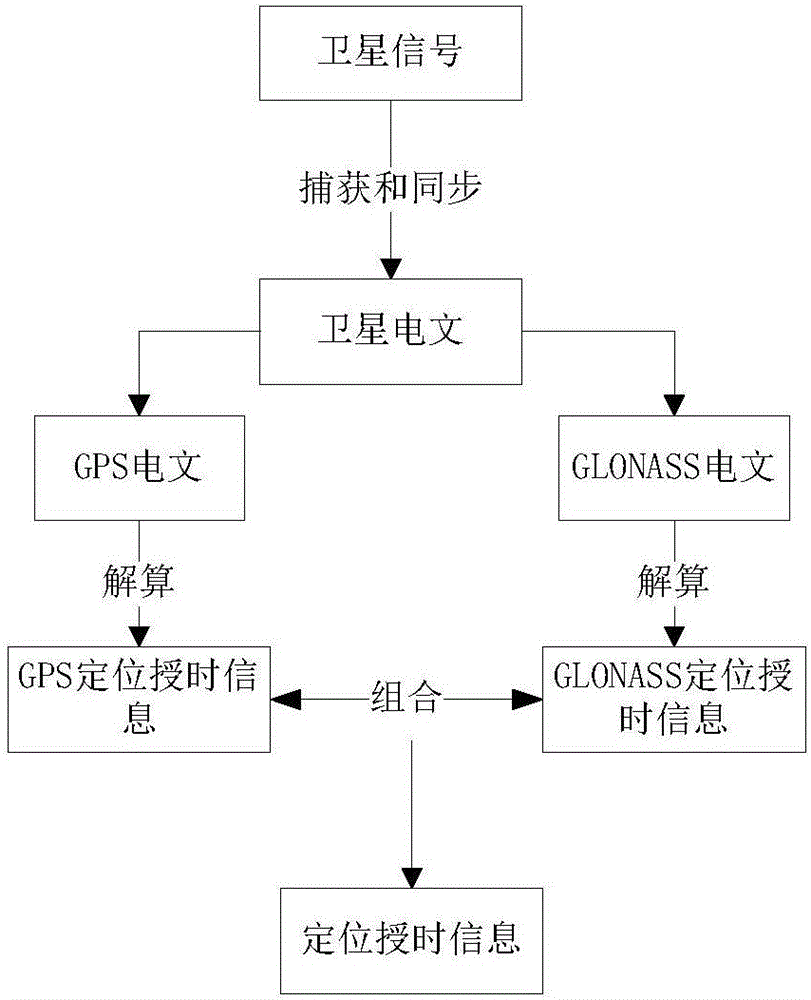
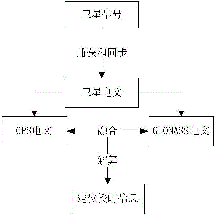
[0017] see Figure 1-3 , the present invention provides a technical solution:

[0018] A method for merging GPS and GLONASS positioning timing, comprising the following steps:

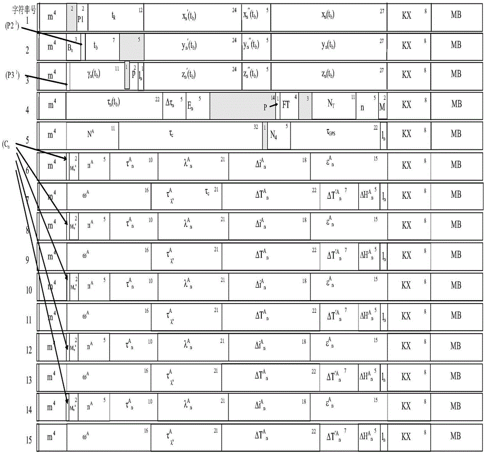
[0019] S1: Determination of the current hour, minute and second: (1) The GPS system publishes the current system time and the 9th to 24th digits of word 8, the 1st to 24th digits of word 9, and the 1st to 24th digits of word 10 The 22 bits contain the satellite clock correction param...


PUM


Abstract

The invention discloses an integrated GPS and GLONAS positioning time service method. The method comprises steps of S1 present hour, minute and second determination; S2, leap second correction; and S3, previous circle overturning. Through the method, after a satellite of two systems is captured, in a resolution process, difference of a GPS and GLONASS system in a navigation message is utilized to realize mutual complementation, depth fusion is carried out, a mode of first resolution and then combination in the prior art is changed, performance of an integrated GPS and GLONAS receiver in the prior art is effectively improved, including reducing the first positioning time, improving time service precision and effectively processing special conditions such as leap second correction and thousand-circle overturning.

Description

technical field [0001] The invention relates to the technical field of positioning and timing services of GPS and GLONASS, in particular to a method for merging GPS and GLONASS positioning and timing services. Background technique [0002] GNSS system (Global Navigation Satellite System), the global y i navigation satellite system. It consists of four navigation systems: GPS (USA), Beidou (China), GLONASS (Russia) and GALILEO (Europe), among which GPS and GLONASS are the most important components. GPS is the abbreviation of the Global Satellite Positioning System proposed by the U.S. military. The system was founded in 1973 and has developed into the most widely used satellite positioning and timing system in the world. It not only plays a huge role in personal navigation and positioning, but also has a lot of room for development in positioning monitoring, emergency assistance, engineering surveying, and facility search. GPS has become the third new growth point of IT ec...

Claims


Application Information

Patent Timeline
Patent Type & Authority Applications(China)
IPC IPC(8): G01S19/33
CPCG01S19/33
Inventor 罗凡程林建国钟少波姚礼银胡贵林李军沈磊
Owner 重庆九洲星熠导航设备有限公司
Why Eureka
Try Eureka