Double-satellite integrated positioning method based on inertial sensor

A combined positioning and double-star technology, which is applied in the field of combined positioning of satellite navigation systems, can solve problems such as navigation blind spots, navigation error divergence, and large geometric factors of positions, and achieve the effects of reducing system material costs, correcting positioning errors, and enhancing applicability

Inactive Publication Date: 2017-04-26
NO 20 RES INST OF CHINA ELECTRONICS TECH GRP
View PDF3 Cites 2 Cited by
  • Summary
  • Abstract
  • Description
  • Claims
  • Application Information

AI Technical Summary

Problems solved by technology

Although the GPS satellite navigation system can provide all-weather, high-precision navigation and timing without being affected by meteorological conditions, it is prone to interference, especially in urban canyons, bridge holes and bushes, where satellites are easily blocked and lost stars, position geometric factor (PDOP) ) is a big phenomenon, when the receiving satellite is less than 4 satellites, for example, only 2 satellites, the GPS navigation system used alone will not be able to locate and there will be a navigation blind spot
When the GPS receiver receives less than 4 satellites, it does not perform navigation and positioning. It is a pity to waste the observation information received by less than 4 satellites.
[0003] At present, MEMS inertial / satellite integrated navigation systems are very common in the case of GPS receiving more than 4 stars. This type of integrated navigation system is directly downgraded to pure inertial navigation when GPS receiving less than 4 stars. Does not utilize measurements from less than 4 satellites already collected by GPS
The navigation error of this method will diverge sharply without the effective correction of GPS, and it is difficult to meet the needs of high-precision and reliable navigation in the case of GPS with few satellites.

Method used


Image

  • Double-satellite integrated positioning method based on inertial sensor
  • Double-satellite integrated positioning method based on inertial sensor
  • Double-satellite integrated positioning method based on inertial sensor

Examples


Embodiment Construction

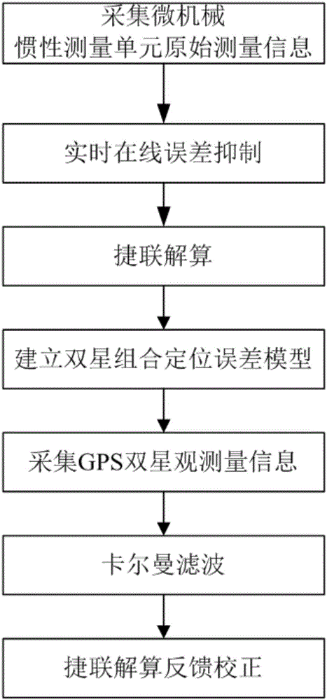
[0015] The present invention comprises the following steps:

[0016] 1) Collect the original measurement information of the micro-mechanical inertial measurement unit in real time;

[0017] Note: The original measurement information includes: X-axis gyro angular rate, Y-axis gyro angular rate, Z-axis gyro angular rate, X-axis accelerometer specific force, Y-axis accelerometer specific force, Z-axis accelerometer specific force.

[0018] 2) performing data real-time online error suppression on the original measurement information of the micromachine;

[0019] Description: The original measurement information of the micro-mechanical inertial measurement unit is sequentially subjected to mean value filtering, median filtering, zero offset elimination and data sliding curve fitting processing, and real-time online suppression of data errors.

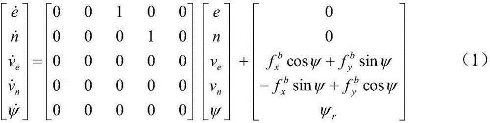
[0020] 3) Strapdown calculation is performed on the micro-mechanical measurement information after the error suppression to realize the mi...


PUM


Abstract

The invention provides a double-satellite integrated positioning method based on an inertial sensor. The double-satellite integrated positioning method based on the inertial sensor has the advantages that the micro-machined inertial sensor and a satellite navigation system are in integrated design, and accordingly the size and the material cost of a satellite integrated navigation system are reduced; in a double-satellite environment, the satellite navigation system is used for obtaining the observed quantity to provide real-time pseudo-range and pseudo-range rate observation information for a Kalman filter, so that positioning error of micro-machined inertial navigation is corrected; the method is simple, feasible, highly practical and capable of improving applicability of the satellite navigation system in a few satellite environment.

Description

technical field [0001] The invention relates to a satellite navigation system combined positioning technology, in particular to a dual-satellite combined positioning method in a satellite / inertial combined navigation system. Background technique [0002] Micro-mechanical inertial sensor navigation system (MEMS_INS) is a low-cost navigation system. Because the drift error of micro-mechanical gyroscopes is much higher than that of laser and fiber optic gyroscopes, it cannot navigate alone for a long time. It is generally used for tens of seconds. the field of short-term autonomous navigation. Although the GPS satellite navigation system can provide all-weather, high-precision navigation and timing without being affected by meteorological conditions, it is prone to interference, especially in urban canyons, bridge holes and bushes, where satellites are easily blocked and lost stars, position geometric factor (PDOP) ) is a big phenomenon, when there are less than 4 satellites, ...

Claims


Application Information

Patent Timeline
Patent Type & Authority Applications(China)
IPC IPC(8): G01C21/16G01S19/47
CPCG01C21/165G01S19/47
Inventor 王小峰寇建辉钟小敏魏敬法王峰波
Owner NO 20 RES INST OF CHINA ELECTRONICS TECH GRP
Why Eureka
Try Eureka