
Three-dimensional geographic information acquisition system

A geographic information and acquisition system technology, applied in geographic information databases, electronic digital data processing, special data processing applications, etc., can solve the problem of not being able to realize the integration of multi-dimensional geographic information collection, the integration of editing and editing, and the inability to meet the needs of geographic information applications. It cannot improve the efficiency and quality of the rapid update of scattered geographic entity change data, and achieve the effects of saving human resources and financial expenditures, improving efficiency and quality, and reducing collection costs

Pending Publication Date: 2017-10-24
北京四维益友信息技术有限公司
View PDF7 Cites 7 Cited by
  • Summary
  • Abstract
  • Description
  • Claims
  • Application Information

AI Technical Summary

Problems solved by technology

However, the existing geographic information collection cannot realize the production mode of multi-dimensional geographic information collection internal and external integration, collection and editing integration, and library integration, and cannot improve the efficiency and quality of the rapid update of scattered geographic entity change data, and cannot meet the requirements of the big data era. Application Requirements for Information

Method used


Image

  • Three-dimensional geographic information acquisition system

Examples


Embodiment Construction

[0015] The specific implementation of the present invention will be described in detail below in conjunction with the accompanying drawings. As a part of this specification, the principles of the present invention will be described through examples. Other aspects, features and advantages of the present invention will become clear through the detailed description. In the referenced drawings, the same reference numerals are used for the same or similar components in different drawings.

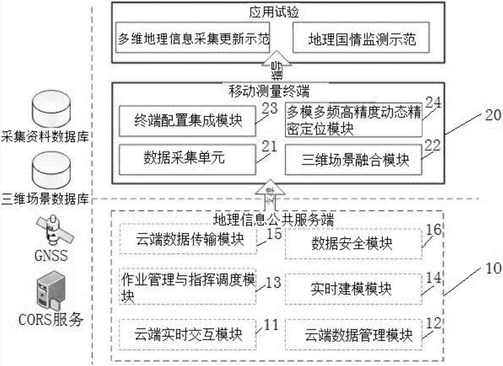
[0016] Such as figure 1 As shown, it is a schematic structural diagram of a three-dimensional geographic information collection system in a preferred embodiment of the present invention. The three-dimensional geographic information collection system of the present invention includes a geographic information public service terminal 10, a mobile measurement terminal 20 connected to the geographic information public service terminal 10 through a network .

[0017] The geographic information public...


PUM


Abstract

The invention discloses a three-dimensional geographic information acquisition system. The system comprises a geographic information public server-side and a mobile measurement terminal; the geographic information public server-side provides the support for a mobile measurement terminal, is responsible for receiving picture and posture information acquired by the terminal to perform the construction and update operation of a three-dimensional model; the mobile measurement terminal is responsible for receiving and displaying the three-dimensional landscape data transmitted by the cloud side, an enhanced realistic display way is used for performing fusion display; and meanwhile, the factor-oriented geographic entity three-dimensional information acquisition work can be performed based on the terminal multisensory. The system realizes the fast, low-cost and efficient update of the disperse geographic entity change, effectively reduces the acquisition cost of the multi-dimension geographic information, can be directly applied to the field classification and quality inspection of the basic surveying, can realize the indoor work and field integrated novel production mode of the multi-dimension geographic information acquisition, the fast update efficiency and quality of the disperse geographic entity change data are promoted, and the application demand on the geographic information by the big data era is satisfied.

Description

technical field [0001] The invention relates to the technical field of information collection, in particular to a three-dimensional geographic information collection system. Background technique [0002] Geographic Information System (Geographic Information System or Geo-Information system, GIS) is sometimes called "geographic information system", which is a specific and very important spatial information system. It is a technical system that collects, stores, manages, calculates, analyzes, displays and describes the relevant geographical distribution data in the entire or part of the earth's surface (including the atmosphere) space with the support of computer hardware and software systems. Location and geographic information are both the core and the foundation of LBS. A simple latitude and longitude coordinate will be recognized and understood by users only after it is placed in specific geographic information and represented as a certain location, sign, or orientation. ...

Claims


Application Information

Patent Timeline
IPC IPC(8): G06F17/30
CPCG06F16/29
Inventor 林善红陈少勤韩刚谢俊峰朱广彬邱儒琼李强洪亮王海涛马晓晶马文强毛征科徐勇任杰余三洋杨光唐应秘龚丽芳吴斌卓徐柳华叶哲璐陈张建祝士杰俞春娜卢智郝天平陈晓茜张露林张丹余晓敏
Owner 北京四维益友信息技术有限公司
Learn More