Variance minimizing method of satellite image local area network based on nonlinear estimation of restriction function

A technology of nonlinear estimation and regional network adjustment, applied in the field of satellite photogrammetry, it can solve the problems of uncontrollable accuracy and loss of function, and achieve the effect of easy design and implementation, and reducing model errors.

Active Publication Date: 2017-11-03
SHANGHAI OCEAN UNIV
View PDF4 Cites 9 Cited by
  • Summary
  • Abstract
  • Description
  • Claims
  • Application Information

AI Technical Summary

Problems solved by technology

This method uses the spectrum correction method to iteratively estimate and solve the correction parameters and ground point coordinates, and sets the number of iterations and the threshold. However, this method cannot control the accuracy, and can only approach the corresponding point, which needs to be matched with the ground point. Whe

Method used


Image

  • Variance minimizing method of satellite image local area network based on nonlinear estimation of restriction function
  • Variance minimizing method of satellite image local area network based on nonlinear estimation of restriction function
  • Variance minimizing method of satellite image local area network based on nonlinear estimation of restriction function

Examples


Embodiment 1

[0074] refer to figure 1 , figure 1 It is a general framework diagram of a satellite image block network adjustment method based on the non-linear estimation of the constraint function of the present invention.

[0075] A kind of satellite image area network adjustment method based on constraint function nonlinear estimation of the present invention comprises the following steps:

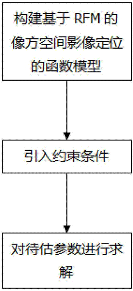
[0076] S01: Construct a function model of image space image positioning based on RFM;

[0077] The Rational Polynomial Coefficient file (Rational Polynomial Coefficient), that is, the RPC file, is provided in the image metadata acquisition, which is used to determine the quantitative relationship between the object space point and the corresponding image point; the image is geometrically corrected and compensated for system errors such as affine transformation, The system error is expressed as the affine transformation of the image point coordinates, and the block adjustment is added to the ration...

Embodiment 2

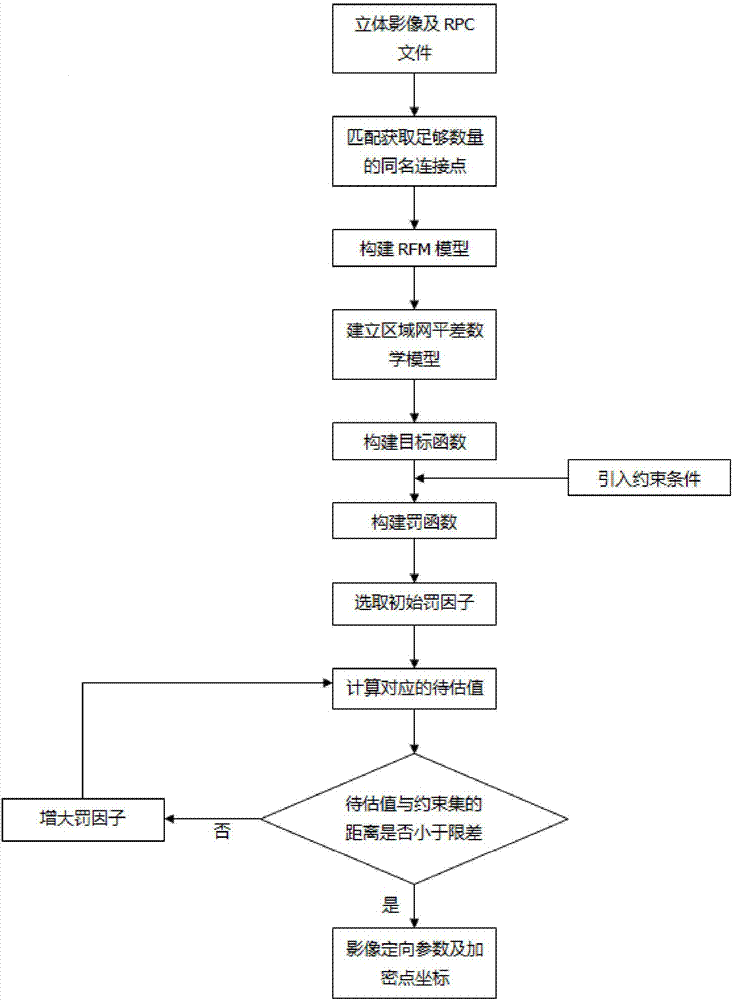
[0101] refer to figure 2 , figure 2 It is a detailed flow chart of a satellite imagery block adjustment method based on the nonlinear estimation of the constraint function. The specific process of the satellite imagery block adjustment method based on the non-linear estimation of the constraint function of the present invention is as follows.

[0102] S01: Construct a function model of image space image positioning based on RFM

[0103] refer to image 3 , image 3 It is a flow chart of the present invention to construct a function model of RFM-based image space image positioning.

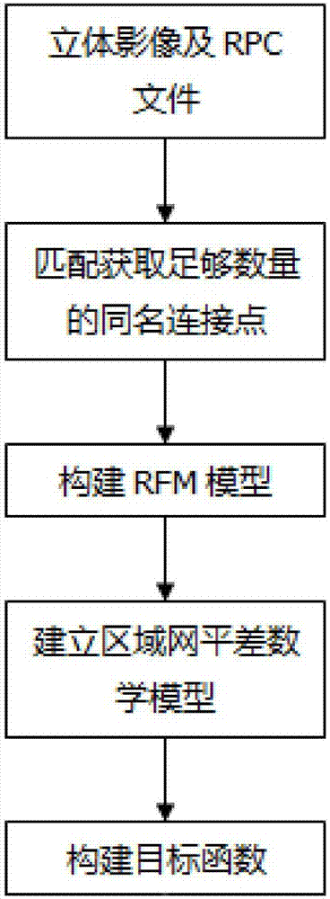
[0104] S011: Acquiring stereo images and RPC files

[0105] Obtain stereo images and RPC files in image metadata.

[0106] S012: Match to obtain a sufficient number of connection points with the same name

[0107] Use the least squares image matching algorithm to match the stereoscopic image sequence, obtain a sufficient number of connection points with the same name, and create a connecti...

Embodiment 3

[0159] The specific implementation of the satellite imagery block adjustment method based on the non-linear estimation of the constraint function of the present invention is as follows.

[0160] S01: Construct a function model of image space image positioning based on RFM

[0161] S011: Acquiring stereo images and RPC files

[0162] Obtain stereo images and RPC files in image metadata.

[0163] S012: Match to obtain a sufficient number of connection points with the same name

[0164] Use the least squares image matching algorithm to match the stereoscopic image sequence, obtain a sufficient number of connection points with the same name, and create a connection point file. The information recorded in the connection point file includes the number of the image where each connection point is located, and the coordinates of the image point.

[0165] S013: Build RFM model

[0166] Using the RPC file, construct the RFM model describing the quantitative relationship between the obje...


PUM


Abstract

The invention relates to a variance minimizing method of a satellite image local area network based on nonlinear estimation of a restriction function. The method comprises the following steps: S01, building a function model of image positioning of an image square space based on RFM (Rational Function Model); S02, introducing a restriction condition; S03, solving parameters to be estimated. The method has the advantages that the restriction condition is introduced on a conventional local area network least variance mathematical model, so that the problem of non-unique solution caused by loss of necessary initial data under a condition of no control points is solved, and meanwhile, unknown parameters are optimally estimated by adopting a restriction function method, an original non-linear form of the functional model is preserved, the non-linearity problem with the restriction condition is converted into the problem of the solution to unconstrained function extreme value, and a model error problem caused by a linear optimal estimation algorithm is avoided, and therefore, high precision of least variance solution of the satellite image local area network under the condition of no control points is ensured.

Description

technical field [0001] The invention relates to the technical field of satellite photogrammetry, in particular to a satellite image block adjustment method based on nonlinear estimation of constraint functions. Background technique [0002] Advances in aerospace technology, computer technology, network technology, and information processing technology have promoted the continuous development of remote sensing and earth observation technology, and high-resolution surveying and mapping satellite systems have continued to emerge. Therefore, high-resolution satellite imagery has become one of the important means of obtaining geospatial information of small and medium scales. The high-precision geometric positioning of images is an important prerequisite for the wide application of high-resolution satellite images and the basis for the production of 4D digital products (DTM, DOM, DLG, DRG) using satellite images. At present, "stereoscopic image--ground control point--aerial tria...

Claims


Application Information

Patent Timeline
IPC IPC(8): G01C11/34G06T7/73G06K9/62
CPCG06T7/74G01C11/34G06T2207/10021G06T2207/10032G06F18/22
Inventor 马振玲邓君坪崔璨璨汪佳丽
Owner SHANGHAI OCEAN UNIV
Why Eureka
Try Eureka