
Fire hazard detection and tracking method of small unmanned helicopter

An unmanned helicopter and fire technology, applied to fire alarms that rely on radiation effects, fire alarms, forest fire alarms, etc., can solve the problem of three-dimensional monitoring that is difficult to achieve accurately in real time and on a large scale, and has not been developed based on low-altitude autonomy Three-dimensional early warning system of mobile network platform, lack of small flying platform and other issues

Active Publication Date: 2017-11-03
SOUTH CHINA UNIV OF TECH
View PDF7 Cites 20 Cited by
  • Summary
  • Abstract
  • Description
  • Claims
  • Application Information

AI Technical Summary

Problems solved by technology

However, due to the constraints of economic and technical conditions, it is still difficult to achieve real-time and large-scale accurate three-dimensional monitoring. The low-cost small unmanned helicopter ultra-low-altitude mobile observation platform is a feasible way to solve this key problem.
[0004] At present, remote sensing technologies such as high-altitude meteorological satellites have been used in the early warning and monitoring of disasters in China. However, due to the lack of relevant small flying platforms, the construction of an accurate and real-time three-dimensional early warning system based on low-altitude autonomous mobile network platforms has not yet been carried out.

Method used


Image

  • Fire hazard detection and tracking method of small unmanned helicopter
  • Fire hazard detection and tracking method of small unmanned helicopter
  • Fire hazard detection and tracking method of small unmanned helicopter

Examples


Embodiment

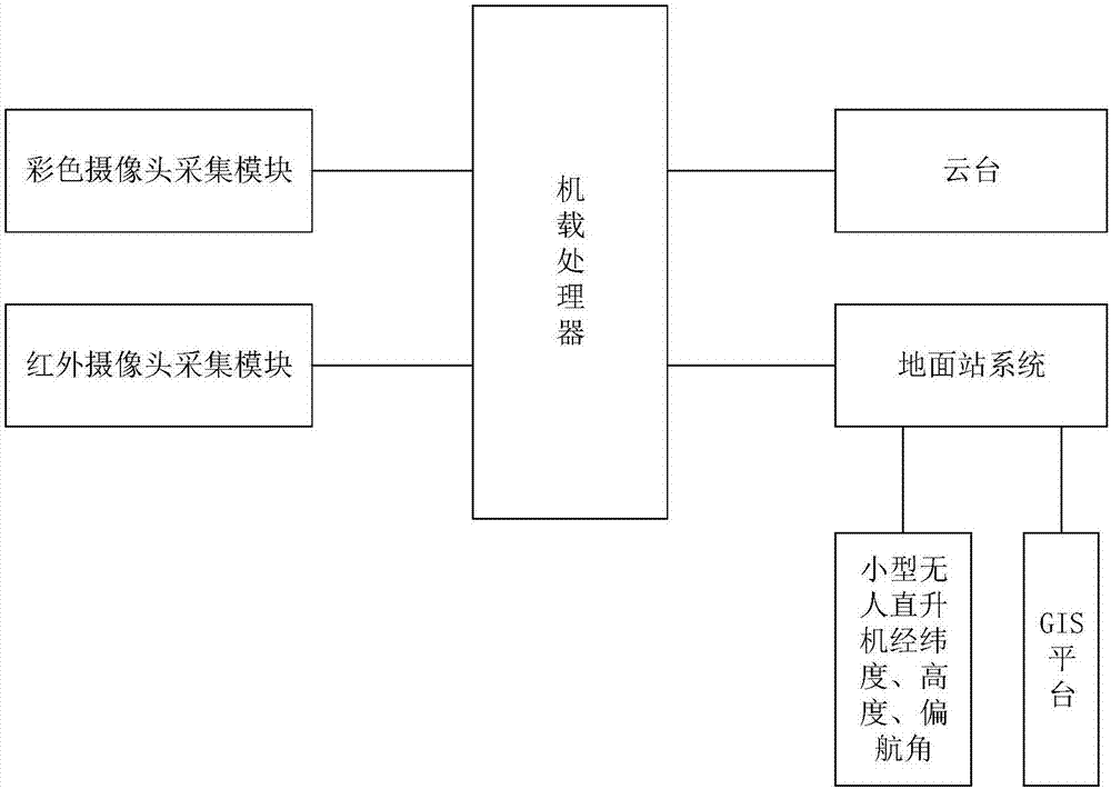
[0056] figure 1 It is a system structure diagram of the fire detection and tracking method of a small unmanned helicopter disclosed by the present invention. The on-board processor is used to process color images and infrared images and extract features, fire judgment and complete the communication between the cloud platform and the ground station system. communication; the infrared camera collection module is used to collect infrared images; the color camera collection module is used to collect color images; ) and sent to the ground station; the ground station system is used to display color images in real time and combine the latitude and longitude, altitude, yaw angle information of the small unmanned helicopter and the inertial measurement unit of the gimbal to obtain the attitude angle (pitch angle and roll angle) of the infrared camera ) to calculate the precise longitude and latitude positioning information of the fire point; the GIS platform is used to mark the precise...


PUM


Abstract

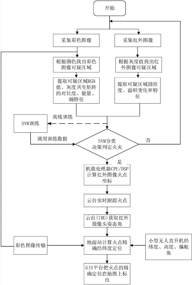
The invention discloses a fire hazard detection and tracking method of a small unmanned helicopter. The method comprises following steps of initializing a system; starting a ground station system and a GIS platform; acquiring color images and infrared images; according to colors, finding out a suspicious image in the color images, and according to the gray scale, finding out a suspicious image in the color images; extracting colors of and gray scale co-occurrence matrix characteristics the suspicious region in the color images; extracting the circularity degree and area change rate characteristics of the suspicious image in the infrared images; judging whether a fire hazard occurs by use of SVM classification decision after an offline training; calculating fire point coordinates in the infrared images and sending the fire point coordinates to a holder through an onboard processor, wherein the holder tracks the fire points in real time; acquiring pose angles of an infrared camera through an inertia measurement unit of the holder; calculating latitude and longitude positioning information of the fire points by combining the latitude and the longitude, the height, the deviation angle information and the pose angle of the small unmanned helicopter through a ground station; and finally, precisely positioning and calibrating the fire points on a map through the GIS platform.

Description

technical field [0001] The invention relates to the technical field of unmanned aerial vehicle fire detection and early warning, in particular to a fire detection and tracking method for a small unmanned helicopter. Background technique [0002] my country is one of the countries most severely affected by natural disasters in the world. There are many types of disasters, wide distribution areas, high frequency of occurrence, and heavy losses. For sudden disasters, especially fires and mountain torrents with limited scope, strong suddenness, great hazards, and difficult to quickly and large-scale ground search and detection, early detection and early warning is a critical means of disaster reduction. At present, the domestic early warning system basically adopts means and methods of fixed-point observation, such as conventional forest fire prevention and lookout posts. However, due to terrain and cost factors, it is difficult for the observation and early warning network to ...

Claims


Application Information

Patent Timeline
IPC IPC(8): G06K9/00G06K9/46G06K9/62G06T7/292G06F17/30G08B17/12G08B17/00
CPCG06F16/29G06T7/292G08B17/005G08B17/125G06T2207/30188G06T2207/30232G06T2207/10016G06T2207/10024G06T2207/10048G06V20/188G06V20/52G06V10/40G06V10/56G06F18/2411G06F18/214G06F18/251
Inventor 裴海龙刘雨曦徐燕翔
Owner SOUTH CHINA UNIV OF TECH
Learn More