Digital mapping method and system based on live-action 3D model

A three-dimensional model and digital mapping technology, which is applied in the field of digital mapping systems based on real-world three-dimensional models, can solve problems such as inability to achieve effective breakthroughs, accuracy bottlenecks, and inability to obtain image data, so as to meet the diverse needs of data results and work. Efficient and realistic effects

Active Publication Date: 2017-11-17
深圳市武测空间信息有限公司
View PDF9 Cites 46 Cited by
  • Summary
  • Abstract
  • Description
  • Claims
  • Application Information

AI Technical Summary

Problems solved by technology

This kind of mapping method only relies on the image data of aerial photography, which is stuck in a bottleneck in accuracy and cannot achieve effective breakthroughs. More importantly, in some places blocked by obstacles, effective image data cannot be obtained and the real scene cannot be fully reflected.

Method used


Image

  • Digital mapping method and system based on live-action 3D model
  • Digital mapping method and system based on live-action 3D model
  • Digital mapping method and system based on live-action 3D model

Examples


Embodiment Construction

[0036] In order to enable those skilled in the art to better understand the technical solution of the present invention, the present invention will be described in detail below in conjunction with the accompanying drawings. The description in this part is only exemplary and explanatory, and should not have any limiting effect on the protection scope of the present invention. .

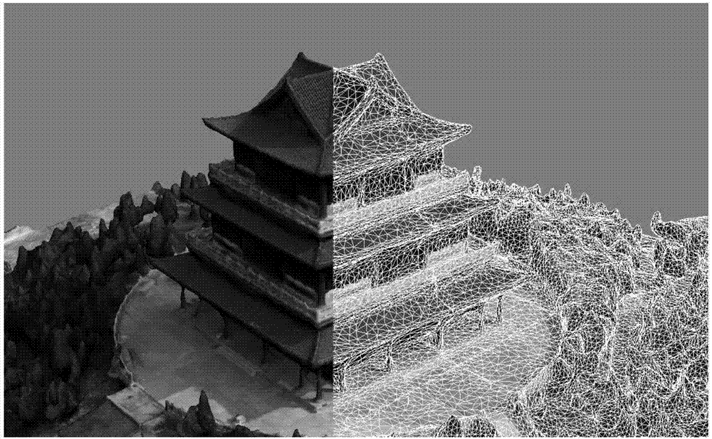
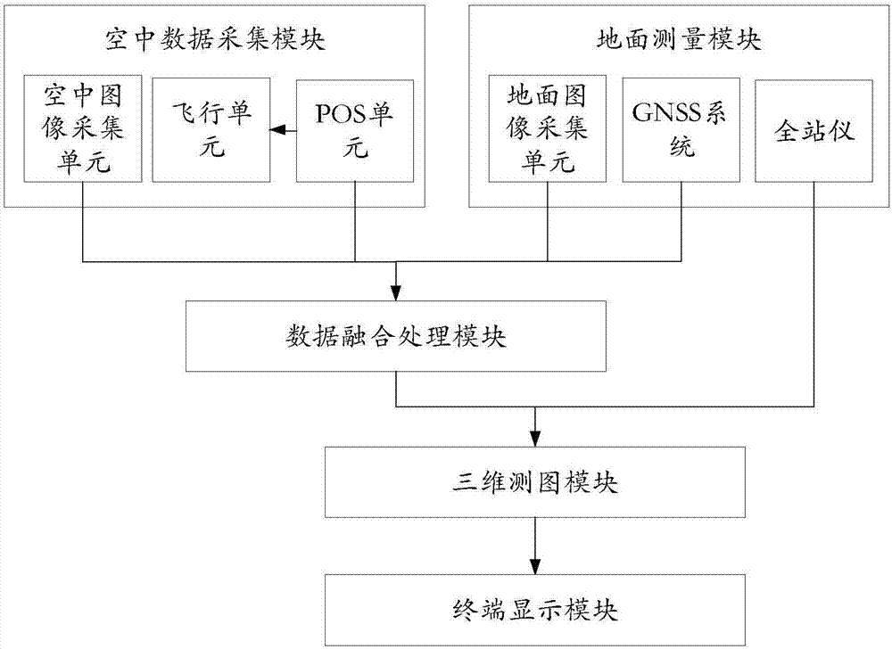
[0037] like image 3 As shown, a digital mapping system based on a real three-dimensional model, including an aerial data acquisition module, a ground measurement module, a data fusion processing module, and a three-dimensional mapping module;

[0038] The aerial data collection module is used to collect aerial image data according to the preset navigation route, and send the collected aerial image data and POS information to the data fusion processing module; the aerial data collection module integrates the POS system and the communication system, and the ground station After the connection is made, ...


PUM


Abstract

The invention relates to the field of photogrammetry and surveying and mapping, particularly to a digital mapping method and system based on a live-action 3D model. Digital mapping is carried out by unmanned aerial vehicle oblique photography 3D modeling and cooperation with a ground survey robot, digital mapping of the data acquisition result is more portable and flexible, at the same time high resolution live-action 3D model data can be acquired, and the sense of reality is strong. A control point coordinate acquired by the ground survey robot can effectively control the overall accuracy of the model, an acquired feature point coordinate can effectively compensate for the defect of low coordinate precision because of the influence of a barrier object on unmanned aerial vehicle aerial photography modeling. The method and system provided by the invention have greatly improved work efficiency, also can acquire vivid 3D topographic and geomorphic data at the same time, and meet the demand for diversified data results.

Description

technical field [0001] The invention relates to the field of photogrammetry and surveying and mapping, in particular to a digital surveying system and method based on a real three-dimensional model. Background technique [0002] With the popularization of the application of oblique photography 3D modeling technology, the application of urban 3D modeling in smart tourism, LBS location service, urban planning, public safety, environmental protection and many other fields is increasing. The modeling results have been able to gradually meet the accuracy requirements of large-scale digital mapping due to the continuous upgrading and improvement of the model's fineness. [0003] The real-scene 3D model mainly obtains images with a certain degree of overlap through aerial photography by drones, and then after inputting the photos, position and attitude information into the oblique photography modeling software, the 3D model can be automatically reconstructed, and the generation is ...

Claims


Application Information

Patent Timeline
Patent Type & Authority Applications(China)
IPC IPC(8): G01C11/00G01B11/24G06T7/50G06T17/05
CPCG01B11/24G01C11/00G06T7/50G06T17/05G06T2207/10028G06T2207/30181
Inventor 张小星郑爽常入鑫王勤勤
Owner 深圳市武测空间信息有限公司
Why Eureka
Try Eureka