
Method for acquiring real-time high-precision displacement of dam through integration of GNSS and ground monitoring network

A monitoring network, high-precision technology, applied in the direction of measuring devices, radio wave measurement systems, satellite radio beacon positioning systems, etc.

Active Publication Date: 2018-03-23
HOHAI UNIV
View PDF15 Cites 6 Cited by
  • Summary
  • Abstract
  • Description
  • Claims
  • Application Information

AI Technical Summary

Problems solved by technology

For the existing dam surface deformation ground monitoring network, the research results of integrating the GNSS-based positioning database with the dam surface deformation ground monitoring network database have not been published yet, and the fused database can combine the data obtained by the two types of monitoring methods. The advantages of information complement each other to achieve the characteristics of dense distribution of data points and high measurement accuracy. Therefore, there is an urgent need for a method to effectively integrate the two monitoring methods with complementary advantages.

Method used


Image

  • Method for acquiring real-time high-precision displacement of dam through integration of GNSS and ground monitoring network
  • Method for acquiring real-time high-precision displacement of dam through integration of GNSS and ground monitoring network
  • Method for acquiring real-time high-precision displacement of dam through integration of GNSS and ground monitoring network

Examples


Embodiment

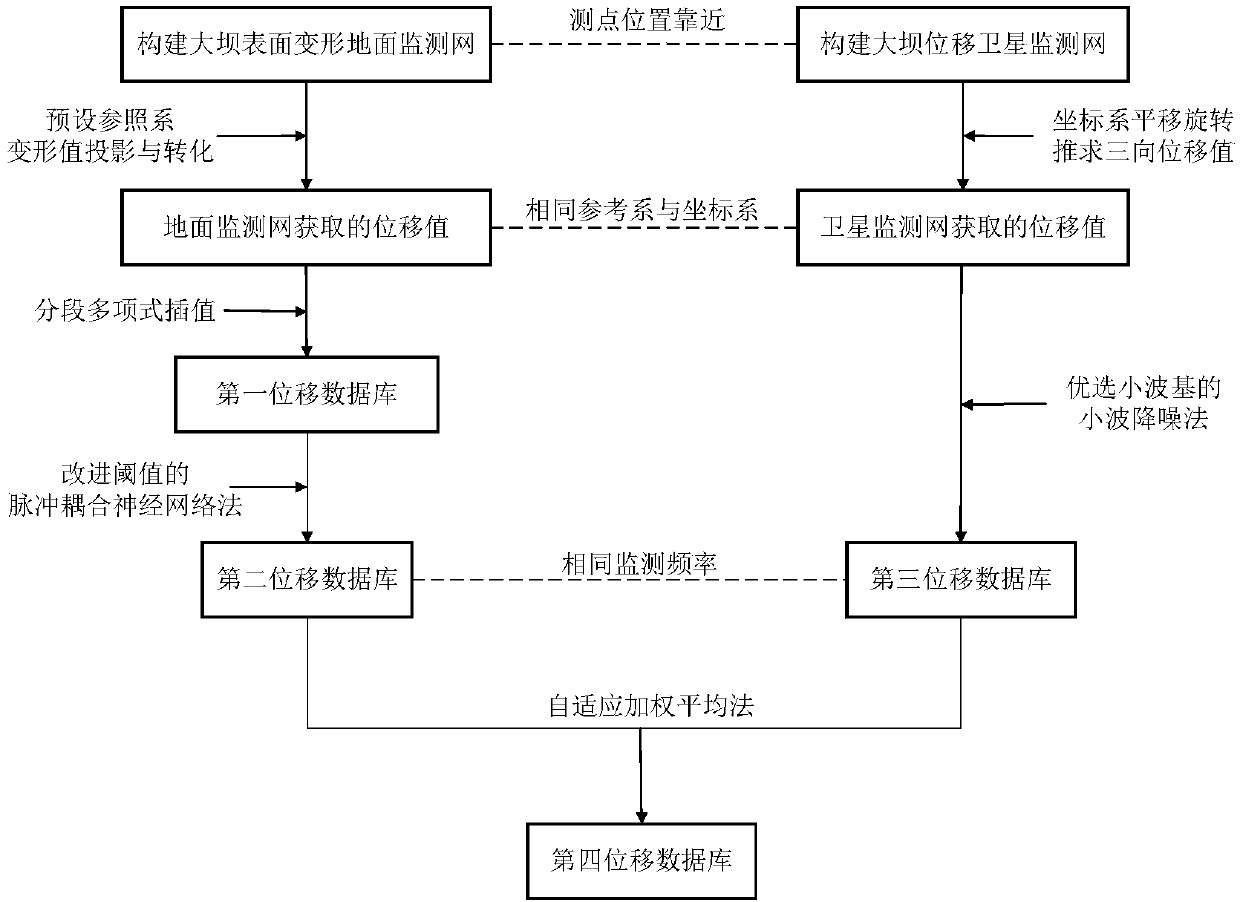
[0033] Embodiment: The method for obtaining the real-time high-precision displacement of the dam by integrating GNSS and the ground monitoring network disclosed in the present invention is aimed at different accuracy levels, different monitoring frequencies, and different failure rates of the dam in the horizontal, downstream, and vertical directions The two sets of monitoring data, namely the dam surface deformation database and the dam displacement satellite database, realize the data fusion of the two monitoring methods on the three-dimensional real-time displacement of the dam. Such as figure 1 As shown, the process is embodied as follows:

[0034]S1: Establish a ground monitoring network for the deformation of the dam surface, specifically using methods such as tension line method, vertical line method, laser alignment method, or precision leveling method, and establish a satellite monitoring network for dam displacement based on GNSS; GNSS monitoring points It should be...


PUM


Abstract

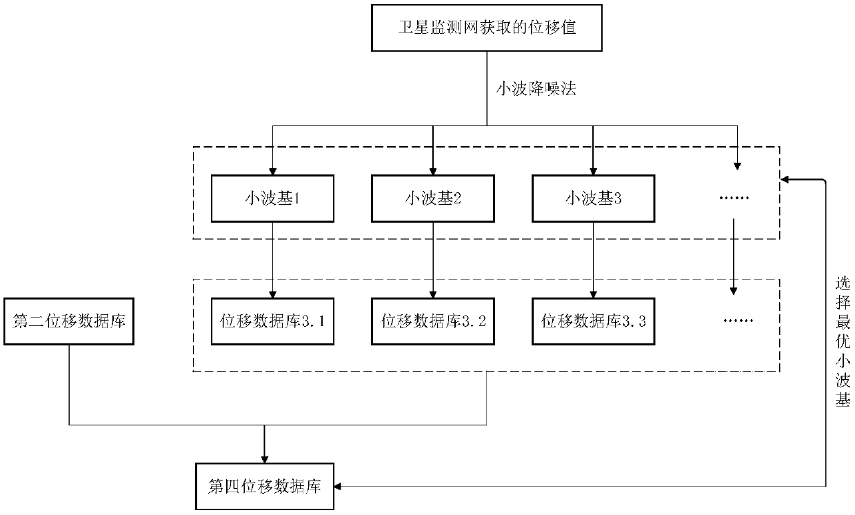
The invention discloses a method for acquiring real-time high-precision displacement of a dam through integration of a GNSS and a ground monitoring network. The method comprises the following steps that S1: the ground monitoring network and a satellite monitoring network are established; S2: a deformation database and a displacement satellite database are converted into the displacement of the same initial state relative to the same reference system; S3: interpolation is performed on the deformation database of the dam surface of long data acquisition interval time so that a displacement database synchronized with the dam displacement satellite database is obtained; S4: noise reduction is performed on the displacement database after interpolation expansion and then data fusion is performedthrough combination of the adaptive weighted mean method and the satellite database processed by wavelet noise reduction; and S5, the data accuracy is calculated, compared and recorded and the wavelet basis is preferably selected according to the data accuracy so that the corresponding fusion displacement sequence in the S4 is obtained. Fusion calculation is performed on the two sets of databasesafter noise reduction through combination of the adaptive weighted mean method, and the obtained database sequences after fusion have the characteristics of being real-time, smooth, continuous, high-precision and reliable.

Description

technical field [0001] The invention relates to a method for obtaining real-time high-precision displacement of a dam by integrating GNSS and a ground monitoring network, and belongs to the field of dam safety monitoring. Background technique [0002] The existing ground monitoring network for surface deformation of dams is usually observed by methods such as line-of-sight method, tension line method, laser collimation method, and vertical line method. It has the characteristics of high measurement accuracy, and the accuracy in the horizontal and vertical directions is at least 0.1mm. However, on the one hand, the failure rate of this type of monitoring instrument is high, on the other hand, the monitoring frequency is low, and the frequency of manual measurement is about once a month. The measurement interval should not be too short, so the existing ground monitoring network does not have the characteristics of reliable and real-time monitoring of the displacement of the d...

Claims


Application Information

Patent Timeline
Patent Type & Authority Applications(China)
IPC IPC(8): G01S19/42
CPCG01S19/42
Inventor 苏怀智杨立夫杨孟韩彰李星方正
Owner HOHAI UNIV
Learn More