
A port detection method based on plsa and bow in high-resolution remote sensing images

A technology of remote sensing images and detection methods, applied in character and pattern recognition, instruments, calculations, etc., can solve the problems of difficulty in high-precision identification of ports, increase in high-precision identification, changes in port detection thresholds, etc., to save information acquisition time and save human effect

Active Publication Date: 2020-03-10
WUHAN UNIV
View PDF4 Cites 0 Cited by
  • Summary
  • Abstract
  • Description
  • Claims
  • Application Information

AI Technical Summary

Problems solved by technology

Specifically, there are many difficulties in the identification of various targets such as ships, buildings, goods, and vehicles contained in the port; the same satellite data will cause huge changes in the detection threshold of the port due to reasons such as time, weather, and photographic attitude.
In addition, the same spectral characteristic curve of remote sensing images may correspond to different ground objects, and the same ground object may have different spectral characteristic curves due to reasons such as illumination and time. These problems increase the difficulty of setting the threshold for port detection.
[0007] (2) There are large differences between different ports, and there are many types of internal targets, which increases the pressure on high-precision recognition
The large differences in size and morphological characteristics have brought great difficulties to the high-precision identification of ports
In addition, as mentioned above, a port can include only a small number of buildings and one or two ships, or it can include many buildings, warehouses, goods, large ships, and vehicles. The variety of objects brings many challenges to the description of the feature layer and the semantic layer. difficulty
[0009] (3) It is difficult to transfer the research method of port recognition in medium and low-resolution images to high-resolution images
[0011] (4) The current high-resolution image port recognition method has not yet solved some key technical problems
However, many key issues, such as how to solve the problems caused by the visual words "polysemous" and "synonymous" in the BOW model in port recognition, and how to construct a feature transformation model that remains unchanged at multiple scales, are still unresolved. wait until effective solution

Method used


Image

  • A port detection method based on plsa and bow in high-resolution remote sensing images
  • A port detection method based on plsa and bow in high-resolution remote sensing images
  • A port detection method based on plsa and bow in high-resolution remote sensing images

Examples


Embodiment Construction

[0055] The technical solutions of the present invention will be further described below in conjunction with the accompanying drawings and embodiments.

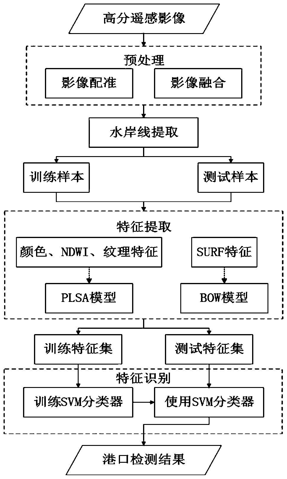
[0056] figure 1 It is a specific flowchart of a high-resolution remote sensing image port detection method based on the probabilistic latent semantic analysis model (PLSA) and the bag-of-words model (BOW) according to the embodiment of the present invention, including image preprocessing, shoreline extraction, and port target features. The steps of extraction, feature model extraction, and classification model extraction are specifically implemented as follows:

[0057] Step 1, image preprocessing

[0058] Two types of preprocessing work, image registration and image fusion, are performed on the high-resolution remote sensing images used to collect and establish the sample library and the high-resolution remote sensing images to be implemented for port inspection.

[0059] Image registration and fusion for panchromatic image...


PUM


Abstract

The present invention relates to a high-resolution remote sensing image port detection method based on PLSA and BOW. First, the image is preprocessed; the NDWI and fractal dimension features of the image are extracted, and the coastline is obtained based on the Grabcut image segmentation method to narrow the search range; Gray histogram statistics, NDWI features, fractal dimension texture features, etc., are introduced into the PLSA model to generate a feature model; at the same time, SURF features are introduced into the BOW model to generate a visual dictionary; then according to the feature model generated by PLSA and the visual dictionary generated by BOW, use SVM The classifier obtains the detection results, and can complete high-precision port detection of high-resolution images in a relatively short period of time. The present invention effectively combines the PLSA model and the BOW model, gives full play to the advantages of the two models, and solves the problems caused by the BOW model "polysemous words" and "synonymous words" in port identification; The line search step can effectively improve the detection accuracy and reduce the detection time.

Description

technical field [0001] The invention belongs to the field of photogrammetry and remote sensing, in particular to a port detection method based on PLSA and BOW in high-resolution remote sensing images. Background technique [0002] Remote sensing is one of the important means of earth observation. With the launch of high-resolution remote sensing satellites such as IKONOS, Quick Bird, WorldView, GeoEye, and Gaofen-2, the spatial resolution and temporal resolution of remote sensing images have been significantly improved. The data sources of high-resolution remote sensing images are getting wider and wider, and the updates are getting faster and faster. Many applications such as object detection, urban planning and land management based on remote sensing technology are of great significance. [0003] Among the many applications above, the supervision of major transportation places such as ports is very important. The port provides great convenience for ships to berth, passen...

Claims


Application Information

Patent Timeline
IPC IPC(8): G06K9/00G06K9/46G06K9/62
CPCG06V20/176G06V10/464G06F18/2193
Inventor 秦昆毕奇童心许凯
Owner WUHAN UNIV
Learn More