Global map data storage and organization method and calling method

A technology for storing organizational and graph data, applied in special data processing applications, electronic digital data processing, structured data retrieval, etc., can solve problems such as low file access efficiency and low system performance

Active Publication Date: 2018-05-15
北京星球时空科技有限公司
View PDF6 Cites 8 Cited by
  • Summary
  • Abstract
  • Description
  • Claims
  • Application Information

AI Technical Summary

Problems solved by technology

[0005] In view of this, the purpose of the embodiment of the present invention is to provide a global one-map data storage organization method and calling method to

Method used


Image

  • Global map data storage and organization method and calling method
  • Global map data storage and organization method and calling method
  • Global map data storage and organization method and calling method

Examples


Embodiment 1

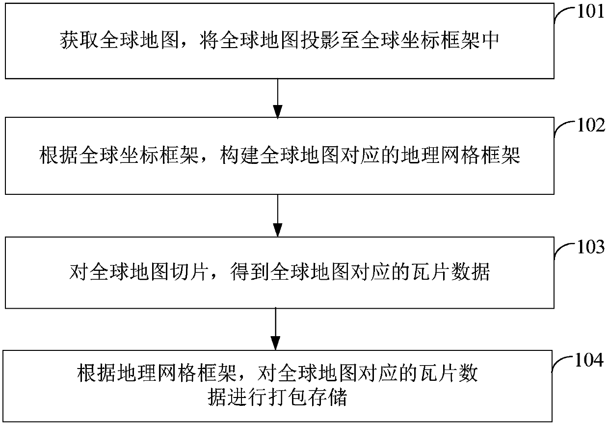
[0061] see figure 1 , the embodiment of the present invention provides a global map data storage organization method, the method specifically includes the following steps:

[0062] Step 101: Obtain a global map, and project the global map into a global coordinate frame.

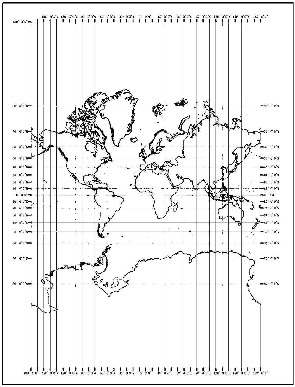
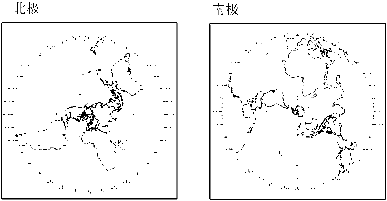
[0063] After obtaining the global map, use the Mercator (Web Mercator) projection method to project the global map, and cut out the first latitude map of the first preset latitude range from the Mercator projected global map; use the positive axis isometric The azimuth projection projects the global map, and cuts out the second latitude map of the second preset latitude range from the global map after the orthographic isometric projection.

[0064] The above-mentioned first preset latitude range is the middle and low latitude range, and the second preset latitude range is the high latitude range of the north and south regions. In the embodiment of the present invention, the first preset latitude range is (-...

Embodiment 2

[0101] see Figure 9 , the embodiment of the present invention provides a global map data call method, the method is used to call the tile data packaged and stored in the above-mentioned embodiment 1, specifically including the following steps:

[0102] Step 201: Receive a map display request from a user, and the map display request carries latitude and longitude coordinates to be displayed and a display level.

[0103] When the user browses the global map through an application related to the electronic map, the user drags the global map to make the terminal display the region he wants to view, and zooms in or out to view specific features in the region. The user submits a browsing request to the terminal through operations such as dragging, zooming in, or zooming out. When the terminal receives the browsing request, the terminal obtains the latitude and longitude coordinates of the location clicked by the user when the operation of dragging, zooming in, or zooming out is com...

Embodiment 3

[0132] see Figure 10 , an embodiment of the present invention provides a global one-map data storage organization device, the device is used to implement the global one-map data storage organization method described in Embodiment 1 above, the device includes:

[0133] The projection module 30 is used to obtain the global map, and project the global map into the global coordinate frame;

[0134] The construction module 31 is used to construct a geographic grid frame corresponding to the global map according to the global coordinate frame;

[0135] The slicing module 32 is used for slicing the global map to obtain tile data corresponding to the global map;

[0136] The package storage module 33 is configured to package and store the tile data corresponding to the global map according to the geographic grid framework.

[0137] The above-mentioned projection module 30 is used to project the global map using the Mercator projection method, and cut out the first latitude map of t...


PUM

PropertyMeasurementUnit
Radiusaaaaaaaaaa

Abstract

The invention provides a global map data storage and organization method and a calling method. The global map data storage and organization method includes the steps of projecting a global map to a global coordinate frame, establishing a global geographic grid frame according to the global coordinate frame, slicing the global map to obtain tile data corresponding to the global map, and packaging and storing the tile data according to the geographic grid frame. The calling method includes the steps of receiving a map displaying request carrying longitude and latitude coordinates and displayinggrades, determining tile packets corresponding to the longitude and latitude coordinates according to the longitude and latitude coordinates and the displaying grades, and obtaining the tile data corresponding to the longitude and latitude coordinates from the tile packets. The complete global map is established by means of the Mercator projection in low-latitude areas and the ortho-axis azimuth projection in high-longitude areas; when the packaged and stored tiles are called, the target tile packets are retrieved from a relatively small number of tile packets, then the target tile data is retrieved from the target tile packets, the time consumed for retrieval is short, and the calling speed and efficiency of mass tiles are improved.

Description

technical field [0001] The present invention relates to the technical field of surveying and mapping and image processing, in particular, to a method for storing and organizing global one-map data and a calling method. Background technique [0002] In current electronic map applications, global maps often use Web Mercator projection, and are constructed with 20 different scales and resolutions. The global map is divided into massive tile data by adopting a four-quadrant recursive "pyramid" subdivision method. Due to the huge amount of tile data, how to efficiently store and call the tile data corresponding to the global map has become an urgent problem to be solved. [0003] A tile file is a typical data of a geographic information system. It is characterized by a small size of a single file, but a huge number of files. Taking a 19-story pyramid as an example, the number of files exceeds tens of billions. Therefore, GIS needs to support the efficient storage and retrieval o...

Claims


Application Information

Patent Timeline
IPC IPC(8): G06F17/30
CPCG06F16/29
Inventor 罗斌李洪省吴雪青韩嘉福
Owner 北京星球时空科技有限公司
Why Eureka
Try Eureka