Terrain multi-scale TIN (Triangulated Irregular Network) online visualization method oriented to virtual earth

A multi-scale and terrain technology, applied in 3D image processing, instrumentation, calculation, etc., can solve problems such as large distortion, irregular vector data of Grid terrain, seamless integration of geological spatial data, easy loss of important geomorphic feature information, etc.

Inactive Publication Date: 2018-10-30
WUHAN UNIV
View PDF5 Cites 10 Cited by
  • Summary
  • Abstract
  • Description
  • Claims
  • Application Information

AI Technical Summary

Problems solved by technology

At present, in terms of terrain processing, most traditional virtual earth systems use the interpolation method to generate the pyramid terrain of the regular grid model. The simplified terrain of this method has low accuracy and large distortion, and it is easy to lose important geomorphic feature information. There are many inaccuracies. deterministic problem and thus cannot be used directly for geographic analysis
In terms of terrain visualization, most systems use terrain rendering based on a regular grid (Grid) model. Although the structure is simple and easy to implement, its rendering accuracy is low, it cannot express micro-topography, and it is prone to a large number of redundant patches.
Furthermore, Grid terrain cannot be seamlessly integrated with irregular vector data and geological spatial data
Compared with the Grid model, the structure of the Triangulated Irregular Network (TIN) model is flexible and easy to expand, and can overcome the defects of Grid terrain rendering. However, the global multi-resolution terrain visualization based on the TIN model is difficult to realize in the virtual earth, and the current research is still immature.

Method used


Image

  • Terrain multi-scale TIN (Triangulated Irregular Network) online visualization method oriented to virtual earth
  • Terrain multi-scale TIN (Triangulated Irregular Network) online visualization method oriented to virtual earth
  • Terrain multi-scale TIN (Triangulated Irregular Network) online visualization method oriented to virtual earth

Examples


Embodiment Construction

[0029] In order to facilitate those of ordinary skill in the art to understand and implement the present invention, the present invention will be described in further detail below in conjunction with the accompanying drawings and embodiments. It should be understood that the implementation examples described here are only used to illustrate and explain the present invention, and are not intended to limit this invention.

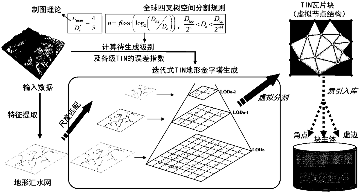
[0030] The technical solution adopted in the present invention is a virtual earth-oriented terrain multi-scale TIN automatic construction and online visualization method. Firstly, a robust space-adaptive terrain feature extraction algorithm is used to extract high-quality terrain from various input terrain data. , and then construct a strict global terrain multi-scale TIN scale parameter model, and constrain high-quality terrain features, through a greedy plug-in TIN construction algorithm to generate high-precision TIN terrain pyramids that take features into...


PUM


Abstract

The invention provides a terrain multi-scale TIN (Triangulated Irregular Network) online visualization method oriented to the virtual earth. The method comprises the following steps of global multi-scale TIN scale parameter mathematical model construction, terrain multi-scale TIN automatic construction and virtual segmentation under characteristic constraints, the online visualization of a multi-scale TIN topography spherical surface and real-time crack elimination, wherein the step of the terrain multi-scale TIN automatic construction and virtual segmentation under characteristic constraintsis realized as follows; the step of the online visualization of the multi-scale TIN topography spherical surface comprises the step of carrying out calculation to obtain visual terrain blocks of different levels according to point-of-sight information; and the step of the real-time crack elimination comprises the following step of carrying out quick decoding during real-time visualization to finish the edge connection of the adjacent boundary of terrain blocks of different levels. By use of the method, while the structural flexibility of the TIN is kept, the multi-scale irregular modeling andthe quadtree segmentation of a large-scale terrain are realized, meanwhile, the seamless real-time rendering of a mixed scale TIN terrain is supported, the terrain data processing and expression accuracy of the virtual earth can be greatly improved, a seamless fusion ability for irregular GF spatial data is also greatly improved, so that the high-fidelity expression requirement of a geographical environment can be met, and each category of reliable geographical analysis application can be supported.

Description

technical field [0001] The invention belongs to the field of computer applications, and mainly relates to a virtual earth-oriented terrain multi-scale TIN automatic construction and online visualization method. Background technique [0002] With the development of earth observation technology, the storage, expression and analysis of global massive geographic environment data have become the focus and difficulty of geographic information science. The virtual earth system has increasingly demonstrated its incomparable advantages over the traditional geographic information system (GIS) in terms of integrated integration and expression of multi-source heterogeneous information such as air, sky, ground, and urban three-dimensional geographic space indoors and outdoors, ground and ground. The powerful information integration ability and the display ability of the global virtual geographic environment make the virtual earth system also have great potential in geographical analysis ...

Claims


Application Information

Patent Timeline
Patent Type & Authority Applications(China)
IPC IPC(8): G06T17/05G06T15/04G06T15/00G06F17/30
CPCG06T15/005G06T15/04G06T17/05
Inventor 郑先伟岳林蔚熊汉江龚健雅周妍
Owner WUHAN UNIV
Why Eureka
Try Eureka