A method for urban municipal census based on UAV low-altitude aerial photography system

A UAV and low-altitude technology, applied in the field of aerial remote sensing image interpretation and processing, can solve problems such as failure to meet accuracy requirements, blurred image texture, affecting work progress and cost, etc., to ensure work quality, improve work efficiency, and improve The effect of accuracy

Active Publication Date: 2021-06-22
QINGDAO JIELIDA GEOGRAPHIC INFORMATION GRP CO LTD
View PDF1 Cites 1 Cited by
  • Summary
  • Abstract
  • Description
  • Claims
  • Application Information

AI Technical Summary

Problems solved by technology

However, the resolution of satellite images currently provided is mainly between 0.3m and 5m, and the image texture is blurred, which cannot accurately and completely interpret the target objects and cannot meet the accuracy requirements of large-scale urban infrastructure censuses, and a large number of The data needs to be verified and re-tested in the field, which affects the work progress and cost

Method used


Image

  • A method for urban municipal census based on UAV low-altitude aerial photography system
  • A method for urban municipal census based on UAV low-altitude aerial photography system
  • A method for urban municipal census based on UAV low-altitude aerial photography system

Examples


Embodiment Construction
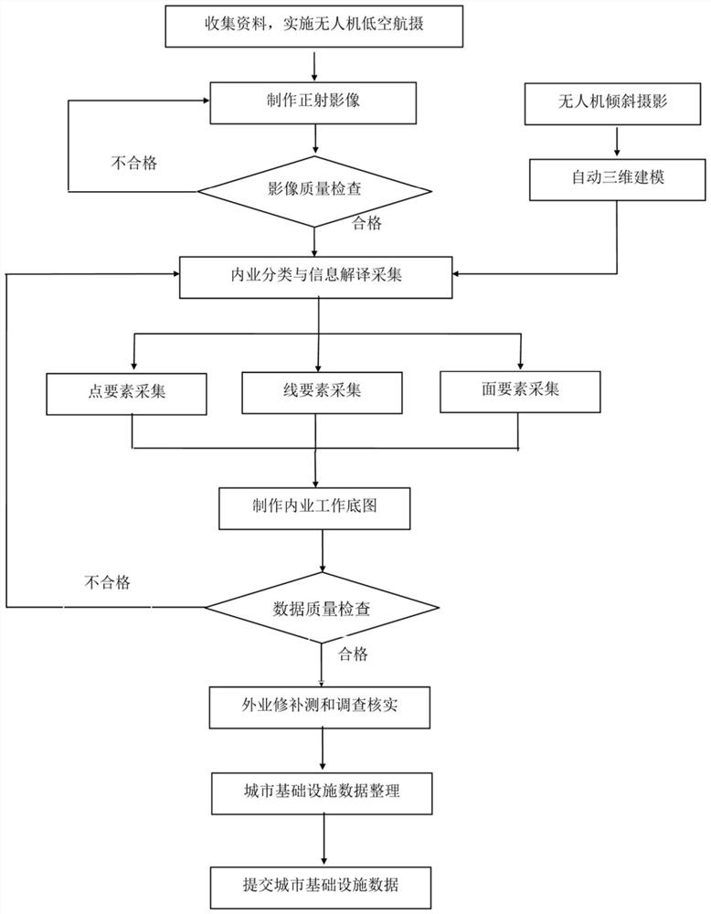
[0055] The basic idea of ​​the present invention is: using unmanned aerial vehicle technology, sensor technology, difference technology, aerial photography to generate high-resolution image technology, remote sensing interpretation application technology, GPS technology, etc. As a supplementary scientific operation method, conduct a high-precision, high-efficiency, and low-cost census of the target urban infrastructure to form a city infrastructure census result with strong current situation, high precision, and comprehensive data content.

[0056] Utilize above-mentioned thought to solve the census problem of urban infrastructure among the present invention Theoretical basis is:

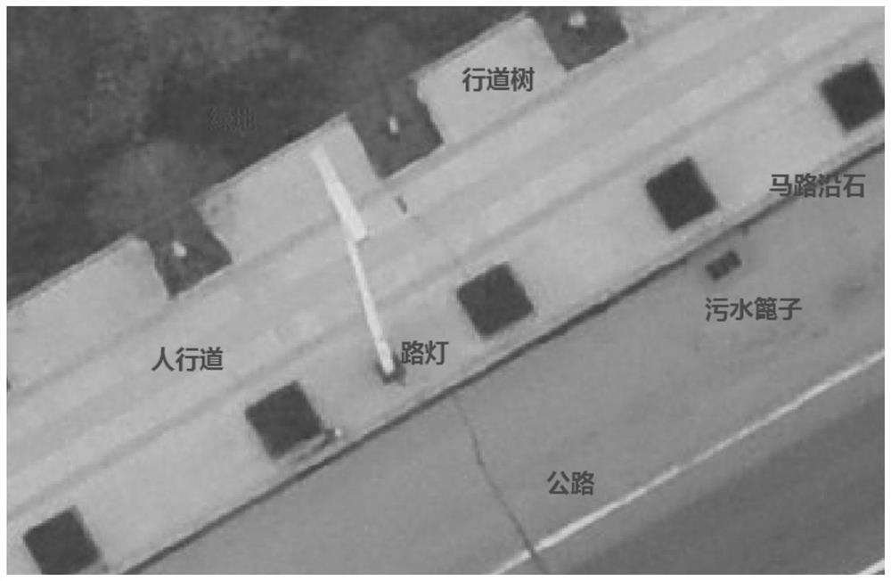
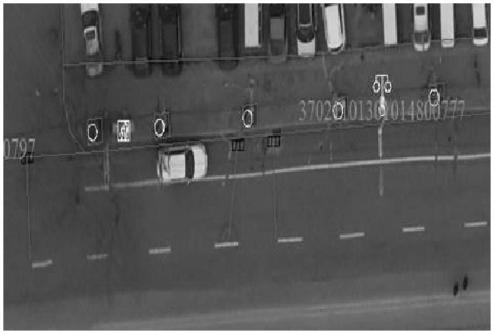
[0057]UAV aerial photography system is a low-altitude aerial photography and mapping system. UAV flight technology can be used to fly at a height of 200-300 meters. The resolution is higher, and images with a resolution better than 0.05 meters can be shot. Advanced image processing software can prod...


PUM


Abstract

The invention discloses a method for urban municipal census based on a low-altitude aerial photographing system of an unmanned aerial vehicle, comprising the following steps: obtaining an image with a resolution better than 0.05 meters by aerial photography of an unmanned aerial vehicle, making a large-scale orthophoto image, and performing remote sensing in the office. The image is interpreted and processed for various types of infrastructure, the working base map is produced in the office, the supplementary measurement and investigation of infrastructure attributes are assisted in the field, and the urban infrastructure data is sorted out in the office to form the image data and vectors required for the general survey of the target urban infrastructure. data. The innovation point of the present invention lies in the operation method that mainly focuses on internal image interpretation and collection, supplemented by field verification. This method changes the data collection method in the prior art of urban infrastructure census and non-field surveying and mapping, saving a lot of time. Field manpower, material resources and time have doubled the efficiency of the urban infrastructure census, reduced the cost of the census, and made the census method more scientific and reasonable.

Description

technical field [0001] The invention belongs to the technical field of aerial remote sensing image interpretation and processing, and in particular relates to a method for urban municipal census based on an unmanned aerial vehicle low-altitude aerial photographing system, which can be applied to urban infrastructure census. Background technique [0002] Urban infrastructure census, mainly through a comprehensive census of urban roads, bridges, street lighting, rivers, waters, sewage treatment, sanitation facilities, garbage disposal stations, green spaces, street trees, parks and other ancillary facilities , comprehensively grasp the basic situation of urban municipal utilities, landscaping, and environmental sanitation industry infrastructure, provide a basis for urban maintenance budgets, and provide basic data support for urban construction management decisions. [0003] The existing census method is mainly based on the outside industry, using dynamic GPS and other survey...

Claims


Application Information

Patent Timeline
Patent Type & Authority Patents(China)
IPC IPC(8): G06K9/00G06Q50/26G01C11/04
CPCG06Q50/26G01C11/04G06V20/13
Inventor 曲维荣李克森徐明张兰于法波张涛王子晗
Owner QINGDAO JIELIDA GEOGRAPHIC INFORMATION GRP CO LTD
Why Eureka
Try Eureka