
Deep accurate mining ground and underground personnel positioning and navigation system combined with Internet of Things

A personnel positioning and navigation system technology, applied in the field of personnel positioning and navigation systems, can solve the problems of not taking into account the underground environment, not having navigation functions, not having communication alarms, etc.

Active Publication Date: 2018-11-06
CHINA UNIV OF MINING & TECH
View PDF5 Cites 7 Cited by
  • Summary
  • Abstract
  • Description
  • Claims
  • Application Information

AI Technical Summary

Problems solved by technology

Usually, these technologies use WiFi, RFID, Bluetooth and other methods for positioning, but most of them are aimed at common environments such as shopping malls and hospitals. There are few positioning systems for deep underground mines, and basically do not have navigation functions. Simple positioning does not take into account the complexity of the downhole environment, it is impossible to monitor the downhole environment, and it does not have the ability to communicate and alarm
At present, there is no mature product on the market that has the functions of underground positioning and navigation, positioning, monitoring, early warning, and communication.

Method used


Image

  • Deep accurate mining ground and underground personnel positioning and navigation system combined with Internet of Things
  • Deep accurate mining ground and underground personnel positioning and navigation system combined with Internet of Things

Examples


Embodiment Construction

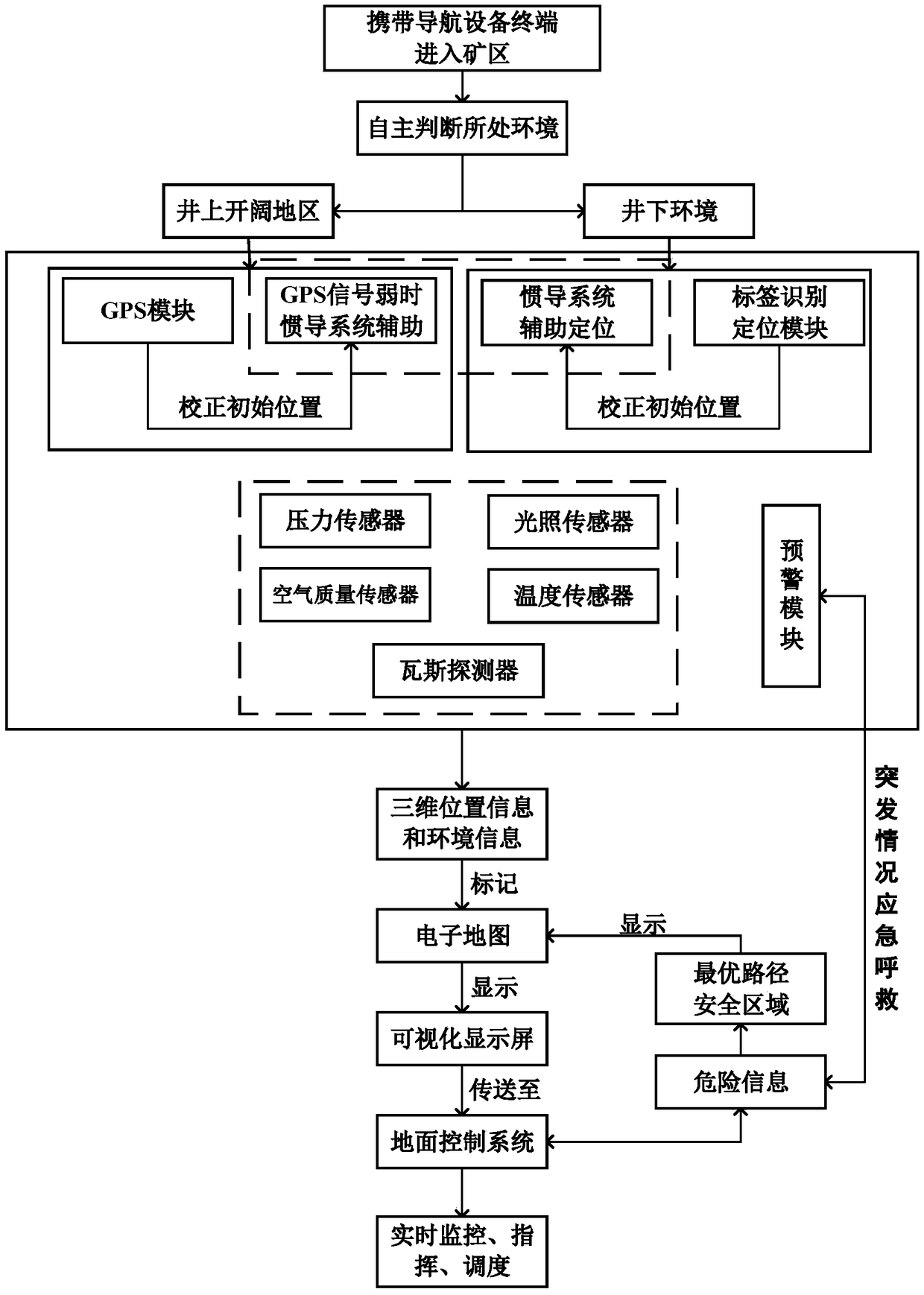
[0029] Attached below Figure 1~2The present invention will be described in further detail with specific embodiments.

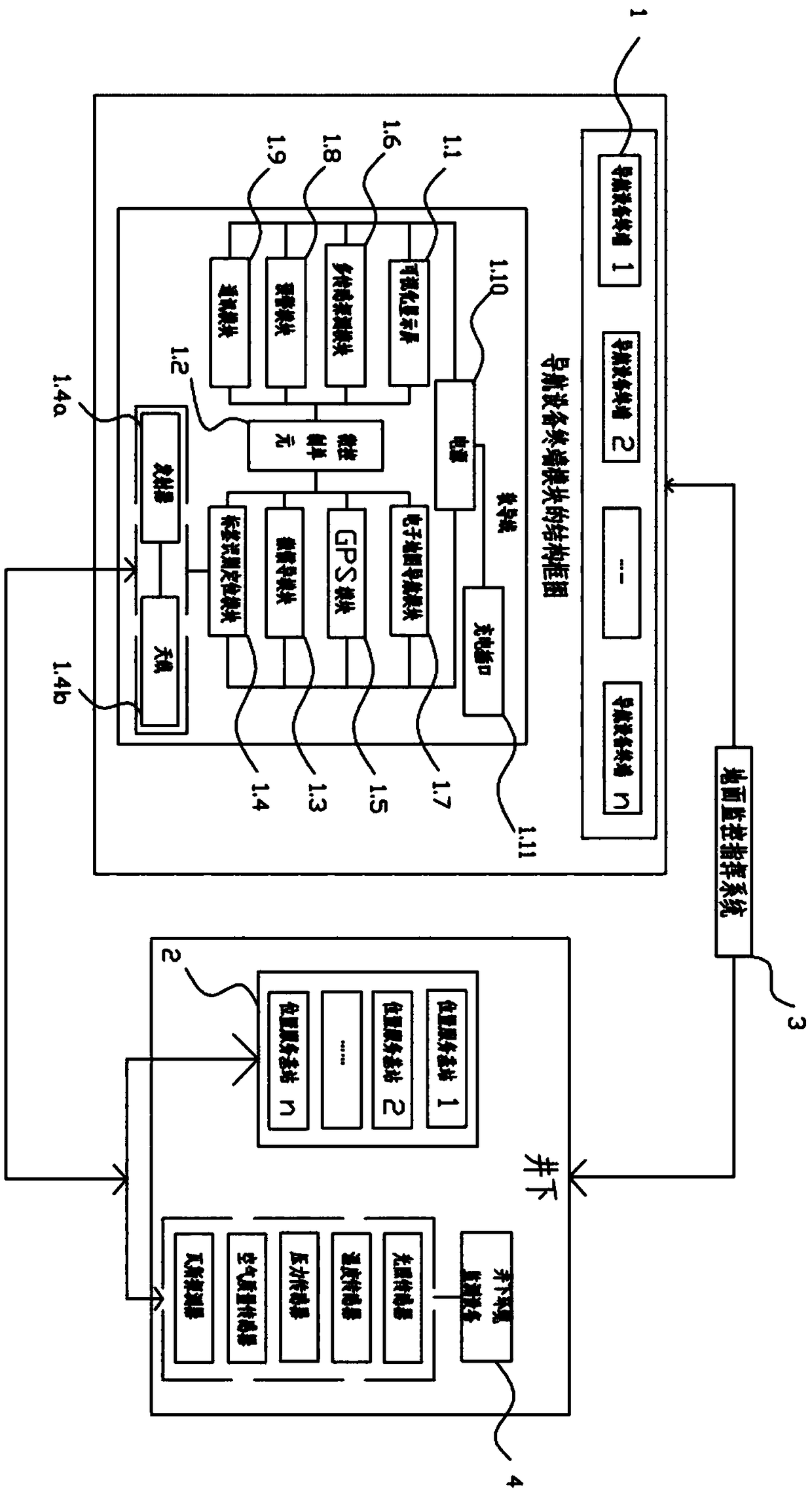
[0030] A positioning and navigation system for personnel in deep and precise mining wells combined with the Internet of Things. The system is composed of a navigation equipment terminal 1, a location service base station 2, a ground monitoring command system 3, and an underground environment monitoring equipment 4; wherein the navigation equipment terminal 1 is equipped with a visual Display screen 1.1, micro-control unit 1.2, micro-inertial navigation module 1.3, label identification and positioning module 1.4, GPS module 1.5, multi-sensor detection module 1.6, electronic map navigation module 1.7, early warning module 1.8, communication module 1.9 and power supply 1.10; visualization Display screen 1.1, micro-inertial navigation module 1.3, label identification and positioning module 1.4, GPS module 1.5, multi-sensor detection module 1.6, electronic map nav...


PUM


Abstract

The invention provides a deep accurate mining ground and underground personnel positioning and navigation system combined with the Internet of Things. The system is composed of a navigation equipmentterminal, a location service base station, a ground monitoring command system, and underground environment monitoring equipment; and the navigation equipment terminal is provided with a visual displayscreen, a micro-control unit, a micro inertial navigation module, a tag identification and positioning module, a GPS module, a multi-sensor detection module, an electronic map navigation module, an early warning module, a communication module and a power supply. According to the deep accurate mining ground and underground personnel positioning and navigation system combined with the Internet of Things provided by the invention, the positioning and navigation of personnel and vehicles in the deep well where a GPS signal is difficult to reach is realized, the location distribution of the underground personnel and vehicles is grasped through a ground monitoring system, so that monitoring and command of the personnel and vehicles are realized; the underground environment is sensed through thecommunication module and the multi-sensor environment monitoring module, so that the occurrence of dangers is prevented; when the dangers occur, people can timely escape and rescue through a communication and positioning and navigation module, thus the life and property safety of the underground personnel and mining area personnel can be guaranteed to the maximum degree.

Description

technical field [0001] The invention relates to a personnel positioning and navigation system and method, in particular to a personnel positioning and navigation system and method for deep precise mining wells combined with the Internet of Things. Background technique [0002] With the large-scale mining of coal in recent years, shallow coal resources have gradually decreased or even begun to dry up, and more and more mines have begun to increase mining depth, changing from shallow mining to deep mining. Generally speaking, the deep part generally refers to the range of 700-1000m. Although increasing mining depth can ensure coal production, it will also bring safety risks. On the one hand, as the mining depth increases, the downhole pressure increases, which makes it more difficult to predict and prevent various disasters. The increase in depth will also increase the ground temperature and deteriorate the operating environment in the well, seriously affecting normal produc...

Claims


Application Information

Patent Timeline
IPC IPC(8): H04W4/021H04W4/024H04W4/30H04W4/38H04L29/08G01S19/49G01D21/02G01C21/16G01C21/00
CPCG01C21/005G01C21/165G01D21/02G01S19/49H04L67/12H04W4/021H04W4/024H04W4/30H04W4/38
Inventor 李增科王一帆赵龙
Owner CHINA UNIV OF MINING & TECH
Learn More