Remote engineering and geological disaster safety monitoring system based on unmanned aerial vehicle and method thereof

A technology for geological disasters and remote engineering, applied in control/adjustment systems, measuring devices, instruments, etc., to facilitate the follow-up operation and maintenance of the project, expand the scope of engineering applications, and facilitate on-site construction

Inactive Publication Date: 2019-03-15
NARI TECH CO LTD +1
View PDF15 Cites 3 Cited by
  • Summary
  • Abstract
  • Description
  • Claims
  • Application Information

AI Technical Summary

Problems solved by technology

However, few of the aforementioned technical solutions involve how to use the fusion and collaborative networking of UAVs and ground sensing acquisition devices to realize remote engineering and geological disaster safety in specific environments (no mains power, no mobile communication network, etc.) Network Design of Monitoring System

Method used


Image

  • Remote engineering and geological disaster safety monitoring system based on unmanned aerial vehicle and method thereof
  • Remote engineering and geological disaster safety monitoring system based on unmanned aerial vehicle and method thereof

Examples


Embodiment 1

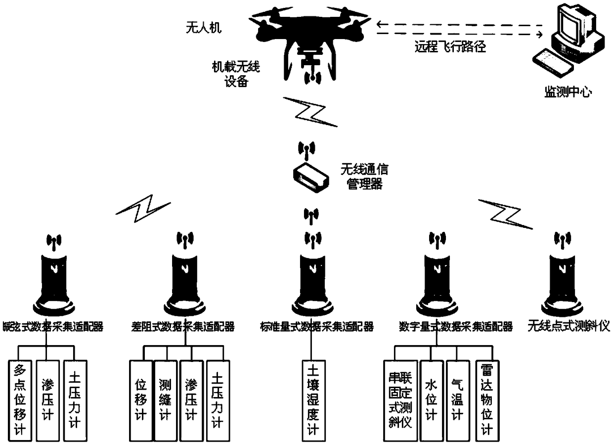
[0039] The embodiment of the present invention provides a remote engineering and geological disaster safety monitoring system based on a drone, including: a data acquisition unit, a wireless communication management unit, a drone, a wireless data acquisition unit provided on the drone, and Monitoring center

[0040] The data collection unit is deployed on the ground to collect monitoring data; in a preferred implementation of this embodiment, the data collection unit includes various sensors, wireless point inclinometers, and one or more low-power Consumption of wireless data acquisition adapter, used to automatically monitor important physical parameters and related environmental parameters of rock and soil in dangerous areas of engineering and geological disasters, such as engineering structure or rock and soil displacement, tilt, seepage pressure, and earth pressure , Temperature, flow, etc. In the actual application process, the wireless data acquisition adapter can be a vib...

Embodiment 2

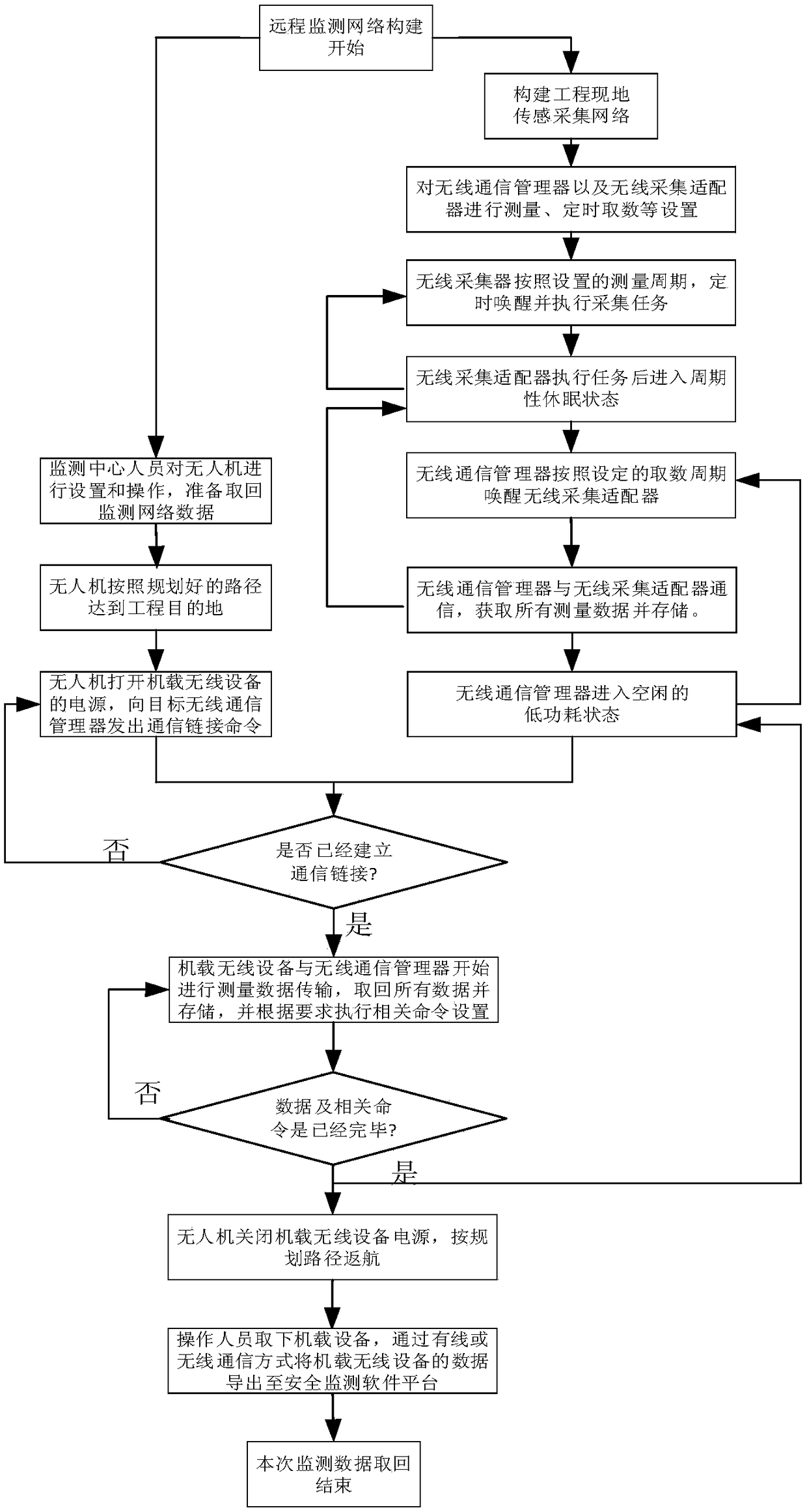
[0054] Based on the same inventive concept as the embodiment 1, the embodiment of the present invention provides a monitoring method for a remote engineering and geological disaster safety monitoring system based on a drone, including:

[0055] (1) Complete the construction of an on-site ground monitoring network at the location of the project. The ground monitoring network includes a wirelessly connected data collection unit and a wireless communication management unit; specifically:

[0056] The installation and implementation of various sensors and wireless data acquisition adapters, namely the completion of the installation and implementation of the data acquisition unit;

[0057] Deploy the wireless communication manager to complete the deployment of the wireless communication management unit;

[0058] Wherein, the wireless data acquisition adapter adopts a built-in lithium ion battery; the wireless communication manager adopts solar power supply, and includes a solar panel, a cha...


PUM


Abstract

The invention discloses a remote engineering and geological disaster safety monitoring system based on an unmanned aerial vehicle and a method thereof. The system comprises data acquisition units, a wireless communication management unit, an unmanned aerial vehicle and a wireless data acquisition unit, wherein the data acquisition unit acquires monitoring data; the wireless communication management unit reads monitoring data from each data acquisition unit and stores the monitoring data; when the unmanned aerial vehicle flies to an engineering destination with the wireless data acquisition unit, the power supply of the wireless data acquisition unit is turned on, and a communication link command is sent to the wireless communication management unit; after the communication link is established, the wireless data acquisition unit receives monitoring data sent by the wireless communication management unit, and when the monitoring data are received, the communication link is disconnected,and the wireless data acquisition unit power supply is disconnected by the unmanned aerial vehicle. Based on the unmanned aerial vehicle, the wireless data acquisition unit, a low-power consumption data acquisition unit, the wireless communication manager and the like, the automatic safety monitoring system with low equipment cost and low operation and maintenance cost is constructed, and the automatic safety monitoring system has the advantages of strong feasibility and good application prospect.

Description

Technical field [0001] The invention belongs to the field of engineering and geological disaster safety monitoring automation technology, and specifically relates to a remote engineering and geological disaster safety monitoring system and method based on drones. Background technique [0002] The engineering and geological disaster safety monitoring automation system can perform real-time monitoring of building structures or landslides and slopes, and predict and warn possible unsafe factors. It is of great significance to ensure the safety of the structure itself and the safety of personnel. The data transmission method of the traditional remote security monitoring system is mainly wireless communication technology. Generally, GRPS data transmission equipment is used where there is GPRS signal coverage; where there is no GPRS signal coverage, high-power digital transmission radio or satellite communication is generally used. The former has higher power consumption and higher req...

Claims


Application Information

Patent Timeline
Patent Type & Authority Applications(China)
IPC IPC(8): G05D1/10G01D21/02
CPCG01D21/02G05D1/101
Inventor 华涛马文锋余有胜罗孝兵崔岗李桂平邹君凌骐芮钧马军建胡少英
Owner NARI TECH CO LTD
Why Eureka
Try Eureka