Alignment method of INS/GNSS/polarization/geomagnetic integrated navigation system based on least squares

An integrated navigation system and least squares technology, which is applied to navigation, navigation, surveying and navigation through speed/acceleration measurement, can solve the problems of poor signal synchronization, dependence, and low precision of inertial navigation systems

Active Publication Date: 2019-04-02
NORTH CHINA UNIVERSITY OF TECHNOLOGY
View PDF9 Cites 15 Cited by
  • Summary
  • Abstract
  • Description
  • Claims
  • Application Information

AI Technical Summary

Problems solved by technology

In the transfer alignment method, the initial alignment accuracy and time cannot be guaranteed due to factors such as structural flexible deformation of the missile carrier and data transmission delay between the main inertial navigation system and the sub-inertial navigation system.
The initial alignment method of the inertial navigation system combined with navigation equipment such as satellites, magnetic compass and star sensors also has problems: among them, the satellite has a large error when the carrier is maneuvering, and the signal synchronization with the inertial navigation system is not good; The magnetic compass depends on the accuracy of the geomagnetic field model, especially when the geomagnetic field is abnormal, there will be a large error, so the initial alignment effect of the moving base is not ideal; the star sensor can estimate the attitude error of the carrier with high precision, but not for initial alignment of the kinematic base during the daytime period in the Earth's atmosphere
Therefore, only the combination of the polarized light sensor and the inertial navigation system for the initial alignment of the mobile base will result in low accuracy, and even the filtering results may diverge
[0005] In summary, the currently commonly used methods for initial alignment of moving bases have disadvantages such as low alignment accuracy and long alignment time, while polarized light sensors and magnetic sensors are extremely insensitive to position errors, and only combined with inertial navigation systems for moving bases. The initial alignment is also not good

Method used


Image

  • Alignment method of INS/GNSS/polarization/geomagnetic integrated navigation system based on least squares
  • Alignment method of INS/GNSS/polarization/geomagnetic integrated navigation system based on least squares
  • Alignment method of INS/GNSS/polarization/geomagnetic integrated navigation system based on least squares

Examples


Embodiment Construction

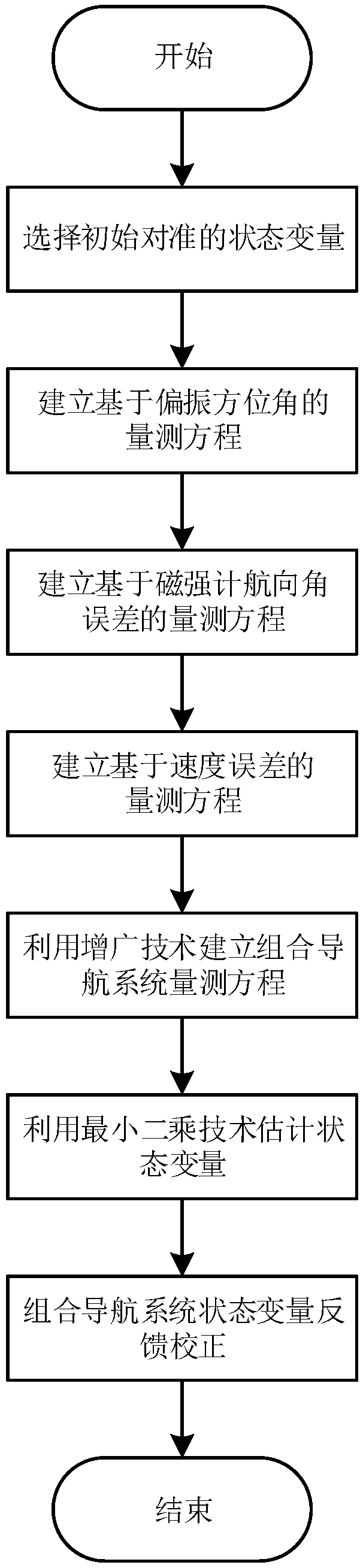
[0082] The present invention will be described in detail below in conjunction with the accompanying drawings and embodiments.

[0083] like figure 1 Shown, the specific implementation steps of the present invention are as follows:

[0084] The first step is to select the state vector of the INS / GNSS / polarization / geomagnetic integrated navigation system:

[0085]

[0086] Among them, φ E , φ N , φ U are the eastward, northward and skyward misalignment angles respectively; δV E , δV N , δV U are eastward, northward and skywise speed errors; δλ, δL, δh are longitude, latitude and height errors respectively; ε x , ε y , ε z It is the carrier coordinate system, that is, the gyro constant value drift under the b system, the origin O of the carrier coordinate system coincides with the center of mass of the carrier, the positive direction of the x-axis is in the same direction as the positive direction of the carrier, the y-axis points to the left along the longitudinal ax...


PUM


Abstract

The invention relates to an alignment method of an INS / GNSS / polarization / geomagnetic integrated navigation system based on the least squares. The method comprises the following steps: selecting an initial aligned state variable; establishing a polarization measurement equation according to the match and fusion of a polarization azimuth angle which is output by a polarization sensor and an azimuthangle which is output by the INS; establishing a geomagnetic measurement equation according to heading angles which are respectively output by a magnetometer and the INS; establishing an error measurement equation according to the match and fusion of the velocity and position information which are output by the GNSS and the velocity and position information which are output by the INS; using the augmentation technology to establish a unified measurement equation of the INS / GNSS / polarization / geomagnetic integrated navigation system; using the least squares technique to estimate the physical quantities such as a misalignment angle, a velocity error, a position error and the like of the INS / GNSS / polarization / geomagnetic integrated navigation system; and performing feedback correction on the attitude, the velocity, and the position of INS / GNSS / polarization / geomagnetic integrated navigation system to improve the initial alignment estimation accuracy.

Description

technical field [0001] The invention relates to an alignment method of an INS / GNSS / polarization / geomagnetism integrated navigation system based on least squares, which can be used to improve the initial alignment accuracy of a moving base of a carrier (vehicle, ship, and aircraft) in the earth's atmosphere, shorten Initial alignment time. Background technique [0002] Before entering the navigation state, the navigation system needs to perform initial alignment, and the initial navigation parameters, including attitude and speed, can be obtained through the initial alignment. Under the condition of moving base, there are various forms of interference such as shaking and vibration during the movement of the carrier. These interference factors will reduce the initial alignment accuracy of the navigation system and prolong the alignment time. Therefore, the initial alignment method of the moving base has always been a difficult and hot issue in the field of integrated navigat...

Claims


Application Information

Patent Timeline
Patent Type & Authority Applications(China)
IPC IPC(8): G01C25/00G01C21/18G01C21/16
CPCG01C21/165G01C21/18G01C25/005
Inventor 杜涛田常正星艳曾云豪
Owner NORTH CHINA UNIVERSITY OF TECHNOLOGY
Why Eureka
Try Eureka