INS/GNSS/polarization/geomagnetism combined navigation alignment method based on Kalman filtering

A technology of Kalman filtering and integrated navigation, which is used in navigation, navigation, mapping and navigation through velocity/acceleration measurement, which can solve the problems of poor system signal synchronization, large error, and long alignment time.

Active Publication Date: 2019-04-02
NORTH CHINA UNIVERSITY OF TECHNOLOGY
View PDF7 Cites 30 Cited by
  • Summary
  • Abstract
  • Description
  • Claims
  • Application Information

AI Technical Summary

Problems solved by technology

In the transfer alignment method, the initial alignment accuracy and time cannot be guaranteed due to factors such as structural flexible deformation of the missile carrier and data transmission delay between the main inertial navigation system and the sub-inertial navigation system.
The initial alignment method of the inertial navigation system and navigation equipment such as satellites, magnetic compass and star sensors also has problems: among them, the error of the satellite is relatively large when the carrier is maneuvering, and the signal synchronization with the inertial navigation system is not good. Good; the magnetic compass depends on the accuracy of the geomagnetic field model, especially when the geomagnetic field is abnormal, there will be a large error, so the initial alignment effect of the moving base is not ideal; the star sensor can estimate the attitude of the carrier with high precision error, but does not apply to the initial alignment of the kinematic base during daylight hours in the Earth's atmosphere
Therefore, only the combination of the polarized light sensor and the inertial navigation system for the initial alignment of the mobile base will result in low accuracy, and even the filtering results may diverge
[0005] In summary, the currently commonly used methods for initial alignment of moving bases have disadvantages such as low alignment accuracy and long alignment time, while polarized light sensors and magnetic sensors are extremely insensitive to position errors, and only combined with inertial navigation systems for moving bases. The initial alignment is also not good

Method used


Image

  • INS/GNSS/polarization/geomagnetism combined navigation alignment method based on Kalman filtering
  • INS/GNSS/polarization/geomagnetism combined navigation alignment method based on Kalman filtering
  • INS/GNSS/polarization/geomagnetism combined navigation alignment method based on Kalman filtering

Examples


Embodiment Construction

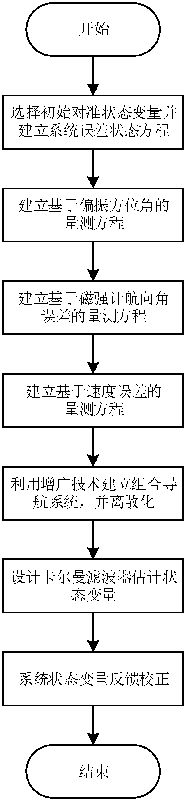
[0095] The present invention will be described in detail below in conjunction with the accompanying drawings and embodiments.

[0096] Such as figure 1 Shown, the specific implementation steps of the present invention are as follows:

[0097] The first step is to select the misalignment angle, velocity error, position error, gyroscope zero bias, accelerometer zero bias and magnetic heading angle error as the state variables of the INS / GNSS / polarization / geomagnetic integrated navigation system, and establish the initial alignment state equation.

[0098] The established equation of state for the initial alignment is:

[0099]

[0100] Among them, F is the system state transition matrix, specifically expressed as:

[0101]

[0102] Among them, A is the state transition matrix of the initial alignment of the standard 15-dimensional strapdown inertial navigation system, and β is the anti-correlation time coefficient.

[0103] X is the state variable of the INS / GNSS / polar...


PUM


Abstract

The invention relates to an INS (Inertial Navigation System)/GNSS (Global Navigation Satellite System)/polarization/geomagnetism combined navigation alignment method based on Kalman filtering. The method comprises the following steps: selecting an initial aligned state variable, and establishing an error equation of a combined navigation system; performing matching and fusing to establish a polarization measuring equation according to a polarization azimuth angle output by a polarization sensor and an azimuth angle output by the INS; establishing a geomagnetism measuring equation according toa heading angle output by a magnetometer and the heading angle output by the INS; performing matching and fusing to establish an error measuring equation according to a speed and position informationoutput by the GNSS, the speed and the position information output by the INS; establishing a unified measuring equation for the combined navigation system by utilizing an augmented reality technology;designing a Kalman filter to estimate physical quantities such as a misalignment angle, a speed error, a position error, etc., of the combined navigation system; and performing feedback correction onan attitude, the speed and the position of the combined navigation system to improve the initial alignment estimation precision. The method has the advantages of being high in precision, small in calculation amount and high in compatibility, and the initial alignment time is reduced.

Description

technical field [0001] The invention relates to a Kalman filter-based INS / GNSS / polarization / geomagnetism integrated navigation alignment method, which can be used to improve the initial alignment accuracy of the moving base of the carrier (vehicle, ship, and aircraft) in the earth's atmosphere, and shorten the initial alignment. Align the time. The invention relates to an initial alignment method in the fields of aviation, spaceflight, navigation, ground transportation, deep-sea diving and the like. Background technique [0002] Before entering the navigation state, the navigation system needs to perform initial alignment, and the initial navigation parameters, including attitude and speed, can be obtained through the initial alignment. Under the condition of moving base, there are various forms of interference such as shaking and vibration during the movement of the carrier. These interference factors will reduce the initial alignment accuracy of the navigation system and...

Claims


Application Information

Patent Timeline
Patent Type & Authority Applications(China)
IPC IPC(8): G01C25/00G01C21/18G01C21/16
CPCG01C21/165G01C21/18G01C25/005
Inventor 杜涛田常正曾云豪星艳
Owner NORTH CHINA UNIVERSITY OF TECHNOLOGY
Why Eureka
Try Eureka