UAV based method for measuring particle size and distribution of river bed surface boulders

A boulder and particle size technology, which is applied in the field of unmanned aerial vehicle measurement in the field, can solve the problems of inability to randomly select points, incomplete data, and difficult to reach, etc., and achieves a scientific and reasonable point selection method, simple numbering method, and simple acquisition. Effect

Inactive Publication Date: 2019-04-16
CHANGSHA UNIVERSITY OF SCIENCE AND TECHNOLOGY
View PDF2 Cites 1 Cited by
  • Summary
  • Abstract
  • Description
  • Claims
  • Application Information

AI Technical Summary

Problems solved by technology

If human beings are used to measure on foot, it will not only take a long time but also fail to take random points (the randomness of sampling is very important), and at the same time there will be some places that are not accessible by roads or difficult to reach, resulting in incomplete or unreliable data

Method used


Image

  • UAV based method for measuring particle size and distribution of river bed surface boulders
  • UAV based method for measuring particle size and distribution of river bed surface boulders
  • UAV based method for measuring particle size and distribution of river bed surface boulders

Examples


Embodiment Construction

[0021] The present invention will be described in further detail below in conjunction with accompanying drawing and example.

[0022] The present invention is mainly aimed at the measurement of particle size distribution of boulders in mountainous rivers, and the tools used in the field include vernier calipers, lime powder, unmanned aerial vehicle and RTK. The operation steps are as follows:

[0023] 1. For the first screening of the target area through remote sensing images, it is usually necessary to determine a certain length of the research river, and each section of the river has corresponding traffic conditions to ensure that it can be reached during field observation.

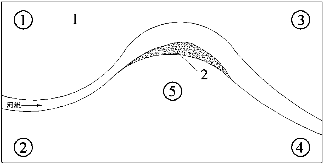
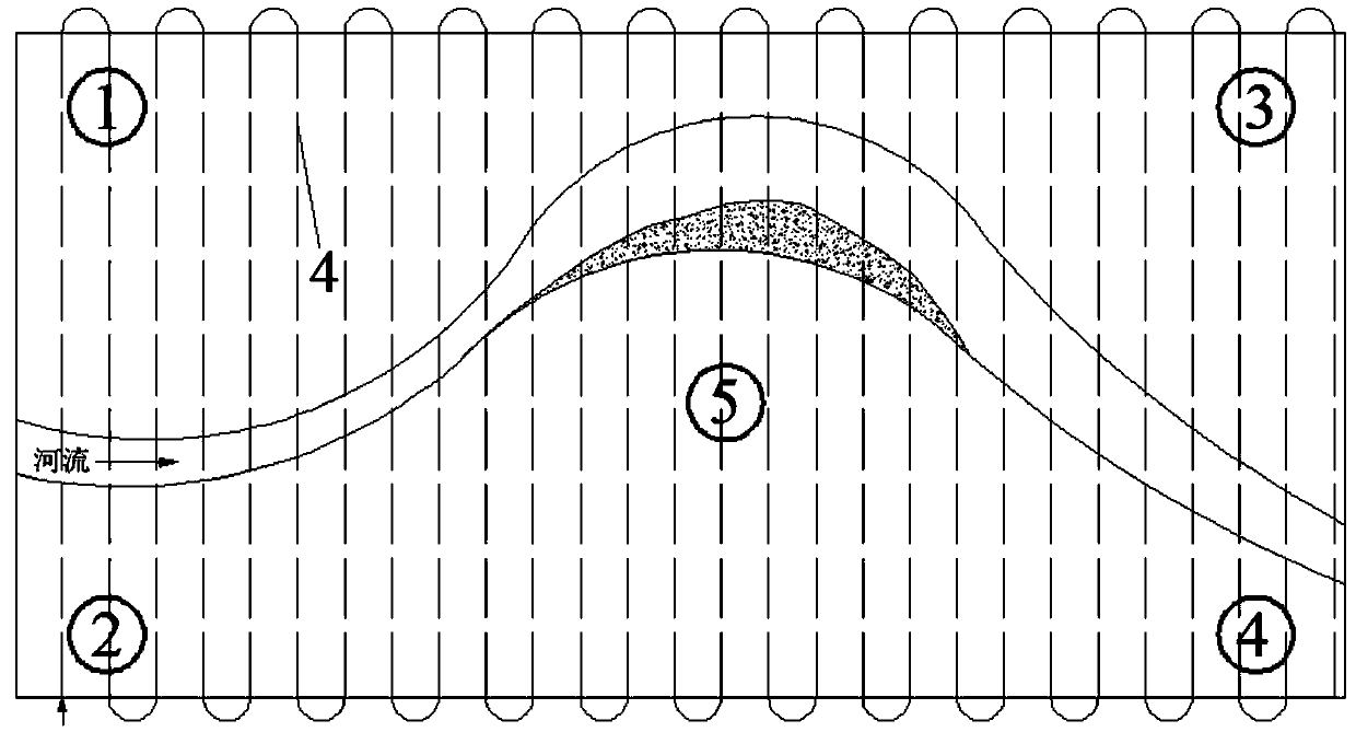
[0024] 2. Conduct on-the-spot investigations on each section of the river, determine the most representative river (hereinafter referred to as the A river), confirm the boundary of the A river, and sprinkle lime powder on the boundary to fix the point 1. When the boundary 4 points are determined, In th...


PUM


Abstract

The invention discloses an unmanned aerial vehicle (UAV) based method for measuring particle size and distribution of river bed surface boulders. The main technical scheme is characterized in that thecenter axis particle size Z values (3) of the boulders are measured on site; the flight height of the UAV and the overlap degree are determined through requirement on the space resolution of the Z values; and finally, orthographic projection of the UAV is corrected and calculated by using relevant software so as to obtain the three-dimensional digital elevation data of a river bed surface, and plane particle size distribution of the boulders, the particle size grading curve and the surface roughness height are obtained in the end. According to the Z values of the boulders, an RTK (Real-time kinematic, real-time dynamic) carrier phase difference technology is needed to be adopted and in-situ accurate positioning is carried out to obtain certain characteristic elevation points, and the characteristic elevation points are used for correcting particle size distribution of the boulders. RTK positioning points are marked through drawing circles on a river bed by lime powder to ensure that images provided by the UAV are easy to identify. The particle size of the boulders aerially measured by the UAV is verified by selecting samples of the center axis particle sizes of the boulders in a small-range field, so that the particle size and distribution of the boulders in a research area can be measured.

Description

technical field [0001] The invention relates to the field unmanned aerial vehicle measurement technology field of mountain river evolution, alluvial hydraulics, debris flow and sedimentology. Background technique [0002] Sediment in natural rivers can be divided into boulders, pebbles, gravel, sand, silt, and clay, among which the median particle size of boulders is greater than 64mm. For natural river channels, the change of sediment particle size can reflect the relative roughness of the surface of the river bed. The larger the particle size of the sediment in the channel and the river bank, the greater the dynamic bed resistance of the river. If it is necessary to carry out scientific research on river fluid bed resistance, shape change, and sediment transport rate, the river bed sediment particle size and relative roughness height are indispensable and important basic data. [0003] The current technical means and measurement methods are mainly based on carrying sieves...

Claims


Application Information

Patent Timeline
Patent Type & Authority Applications(China)
IPC IPC(8): G01N15/02
CPCG01N15/0227
Inventor 李志威李想胡旭跃
Owner CHANGSHA UNIVERSITY OF SCIENCE AND TECHNOLOGY
Why Eureka
Try Eureka