A gis fault precise location method and location system based on vibration signal
A vibration signal, precise positioning technology, applied in the fault location, instrument, testing dielectric strength and other directions, can solve the problems of lack of precise positioning, inability to determine specific parts, and single application scope of monitoring methods.
- Summary
- Abstract
- Description
- Claims
- Application Information
AI Technical Summary
Problems solved by technology
Method used
Image
Examples
Embodiment Construction
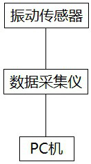
[0031] A GIS fault precise location method based on vibration signals, adopting a GIS fault precise location system; the GIS fault precise location system includes successively connected vibration sensors, data acquisition instruments and PCs, and the vibration sensors are fixedly installed on the GIS equipment shell surface;
[0032] Wherein, the vibration sensor is used to collect the vibration signal of the GIS equipment in real time, and transmits the vibration signal to the data acquisition instrument; the data acquisition instrument is used to receive the vibration signal, and successively undergoes noise reduction, filtering and A / D After the transformation process, the vibration signal is transmitted to the PC; the PC is used to receive the vibration signal output by the data acquisition instrument, and perform GIS fault location analysis to give the location result; the vibration sensor is a ferromagnetic sensor, which is absorbed by the Fixed installation is carried ...
PUM
 Abstract
Description
Claims
Application Information
 - R&D
- Intellectual Property
- Life Sciences
- Materials
- Tech Scout
- Unparalleled Data Quality
- Higher Quality Content
- 60% Fewer Hallucinations
Browse by: Latest US Patents, China's latest patents, Technical Efficacy Thesaurus, Application Domain, Technology Topic, Popular Technical Reports.
© 2025 PatSnap. All rights reserved.Legal|Privacy policy|Modern Slavery Act Transparency Statement|Sitemap|About US| Contact US: help@patsnap.com


