Spatial Information Change Detection and Classification Method Based on Spatial Information and Statistical Learning

A spatial information and change detection technology, applied in the field of spatial information change detection and classification based on spatial information and statistical learning, can solve the problems of low overall efficiency, time-consuming, low precision, etc., and achieve improved detection accuracy, simple method, The effect of filling data gaps

Active Publication Date: 2021-09-21
重庆财经学院
View PDF6 Cites 0 Cited by
  • Summary
  • Abstract
  • Description
  • Claims
  • Application Information

AI Technical Summary

Problems solved by technology

[0005] Based on the lack of underground spatial information in the existing spatial information, the detection and classification of spatial information changes in the detection of vector data have problems such as low accuracy, long time consumption, and low overall efficiency. The learned spatial information change detection and classification method, through comprehensive collection of spatial information, analysis and determination of the change characteristics and classification rules of various spatial elements in the vector layer, combined with statistical learning theory, using the support vector machine model for sample training, so as to achieve Rapid detection and classification of spatial information changes, and improve detection accuracy

Method used


Image

  • Spatial Information Change Detection and Classification Method Based on Spatial Information and Statistical Learning
  • Spatial Information Change Detection and Classification Method Based on Spatial Information and Statistical Learning
  • Spatial Information Change Detection and Classification Method Based on Spatial Information and Statistical Learning

Examples


Embodiment 1

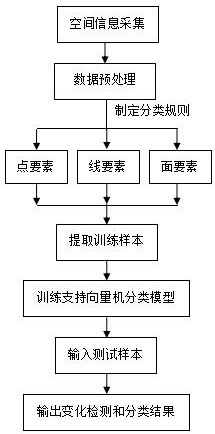
[0038] This embodiment takes road information as an example, and provides a spatial information change detection and classification method based on spatial information and statistical learning, including the following steps:

[0039] (1) Spatial information collection: collect new and old road information in the same research area;

[0040] (2) Data preprocessing: unify the obtained new and old road information data;

[0041] Wherein, the unified processing refers to unifying the data format, attribute format and coordinate system of the road information data before and after the change, so as to perform matching and comparison.

[0042] (3) Formulate spatial information change detection and classification rules: match the spatial elements before and after the change, and formulate corresponding change detection and classification rules according to the characteristics of the spatial elements;

[0043] Wherein, the matching of the spatial elements includes attribute matching an...

Embodiment 2

[0051] This embodiment takes groundwater distribution information as an example, and provides a spatial information change detection and classification method based on spatial information and statistical learning, including the following steps:

[0052] (1) Spatial information collection: collect new and old groundwater information in the same research area;

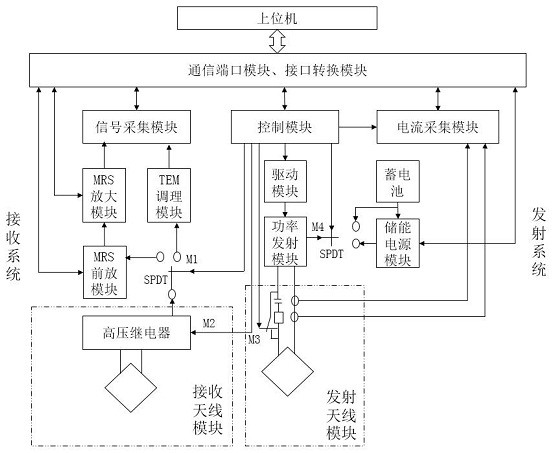
[0053] Using detection devices to collect groundwater information in the study area, the specific steps are as follows:

[0054] a. Select the detection area and arrange the transmitting coil in the form of a square loop;

[0055] b. Select the data collection point and lay the square receiving coil;

[0056] c. Start the detection device to detect the distribution of groundwater through the emission and reception of electromagnetic signals;

[0057] d. Use the inversion software in the host computer to invert and interpret the received information to obtain the water content at different depths of the collection point...


PUM


Abstract

The invention discloses a spatial information change detection and classification method based on spatial information and statistical learning. By comprehensively collecting spatial information, analyzing and determining the changing characteristics and classification rules of various spatial elements in a vector layer, combined with statistical learning theory, Use the support vector machine model for sample training, and then detect and classify spatial information changes; through the above method, the present invention can realize comprehensive and rapid detection and classification of spatial information changes, improve detection accuracy, and the method is simple and applicable to When the number of samples is small, the scope of application is wider.

Description

technical field [0001] The invention relates to the field of spatial information change detection, in particular to a spatial information change detection and classification method based on spatial information and statistical learning. Background technique [0002] Spatial information, as information that reflects the spatial distribution characteristics of geographic entities, is an important infrastructure resource. The timely and accurate update of its data is related to the sustainable development of geographic information systems. The current update methods of spatial information can be divided into batch update and incremental There are two types of updates: Batch update refers to deleting all old data within the research scope and replacing them with new data. This update method requires the production of all data, which not only requires a large workload and takes a long time, but also repeatedly stores unchanged data. A large amount of redundant data is generated, w...

Claims


Application Information

Patent Timeline
Patent Type & Authority Patents(China)
IPC IPC(8): G06K9/62G01V3/12
CPCG01V3/12G06F18/2411
Inventor 熊萍黄丹周猛
Owner 重庆财经学院
Why Eureka
Try Eureka